Month number three at Boulder Beach on Lake Mead…
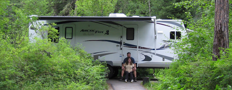
Our last six weeks at Lake Mead RV Village at Boulder Beach continued to be very comfortable. After spending a month in an upper site, we spent the last two weeks in a spacious lake view site. The campground got steadily busier as snowbirds started migrating north. The weather has also been nearly perfect making it easy for Vegas folks to escape to “the lake” for a pleasant weekend. We stayed very busy and time has flown!

An upper site; long narrow gravel pull-through sites; 6 month limit

A lake view site; huge cement pads with hook-ups on both sides; 2 week limit
Adventures…


Tony took us to Keyhole Canyon. The short, but impressive slot canyon is about 10 miles south of Boulder City. It’s known for it’s large number of ancient Indian petroglyphs. We checked them out and then wandered up another nearby wash to find a geocache.
It was warm and we were hungry so we decided to detour to Dairy Queen for a refreshing cold treat. Marge met us there! We enjoyed our snack and had a wonderful conversation.


Arleen and Tony entering Keyhole Canyon / Arleen and Tony with a geocache


Tony wanted to show us more petroglyphs, so he guided us to Boy Scout Canyon. We parked near the top of the slot canyon, which narrows and descends rapidly to meet the Colorado River about five miles downstream of Hoover Dam. We only went a mile and a half down…it gets much tougher beyond. We had a lot of fun playing on the “elephant rock”, then we rounded the next bend and saw some desert bighorn sheep. As we slowly approached the sheep, more appeared, and then even more…there were at least 30! The first group was ewes with their kids and the second group were all rams, some of them pretty impressive. It was amazing to think that those rams will not be friends during the fall mating season! After the sheep disappeared over a ridge, we looked around and spotted petroglyphs everywhere! We really enjoyed this hike and made tentative plans to return to explore it more.


Petroglyphs everywhere!


Riding the elephant / A big desert ram


Tony took us on a bicycling adventure through the Wetlands Park. Carlos, from the Nellis Air Force Base Outdoor Adventure program, also joined us. We parked at Lake Las Vegas and headed off in a clockwise direction. Much of the route south of Vegas Wash is unfinished packed dirt and gravel, more conducive to mountain bikes, but doable with tough road bikes. The Wetlands Park visitor center is impressive and a busy hub for folks touring the popular park. Cyclists are limited to a few trails and have to be careful of tons of walkers. Most walkers don’t go past the bridge, so we sped things up on the smooth, paved trail. The rollercoaster-like route is all kinds of fun, but a couple of the short steep hills got the best of us. We really enjoyed this loop!


Carlos and Tony climbing a steep hill / Carlos, Me, Arleen, and Tony


We spent a morning geocaching with Stef and Brinley near their home. We found four caches and got some good exercise. Portions of the route were tough in steep terrain with loose rock. The last cache had a great view of Lake Mead. Brinley cracked us up when she climbed in Stef’s lap for a break!


A geocache was hidden in the front bumper / Arleen with a geocache…our campground is in the background


Tony planned a tough day for us: climb Frenchman’s Peak and then explore Gypsum Cave.
We expected the winds to increase through the day so we headed to Frenchman’s Peak first. On the way up we detoured to look for a geocache. It was supposed to be in an abandoned VW Bug, but we didn’t find the cache. We continued up the steep route and rested at the saddle between North and South Frenchman Peak. We noticed small plumes of dust being kicked up on the farther, higher south peak. Hopefully we would be ahead of the winds, but we were getting concerned. We headed up the final steep, rocky ascent of the north peak and immediately started getting pushed around by gusty winds. As we popped over the peak’s shoulder, just a few hundred feet from the top, we were blasted by 40-60mph winds. We quickly huddled to discuss our options and headed right back down…the summit would have to wait for another day. The wind was in our faces the entire way back. We proceeded slowly, keeping our heads down, and getting pelted by dust and sand…it was miserable! We were very glad to dive into the truck!


Almost to the shoulder / Just a few hundred feet from the top…winds were too strong…we turned around


40-60mph winds and a bunch of dust…yuck!
We arrived near Gypsum Cave and thankfully, the winds weren’t as bad. The cave was pretty cool, but it was disheartening to see so much graffiti and broken glass. We found two nearby geocaches and declared it a successful day.


Tony and Arleen in Sloth Cave


Tony, Stef, and Brinley joined us on a loop route through two slot canyons that lead to Lake Mead. We went up one of the canyons to the River Mountains Loop Trail, and then dropped into the impressive White Owl Canyon. The crazily eroded walls raise straight up, nearly a hundred feet and are less than 15 feet apart in places. We also walked through a couple of drainage culverts…they are always a little eerie. The 3.3 mile route was a pleasant length and very enjoyable.


Playing around in White Owl Canyon with Stef, Brinley, and Tony


A beautiful hike near Lake Mead


Red Rock Canyon is a gem of a park on the southwest side of Las Vegas. It has many miles of hiking trails, a very scenic one way 13 mile loop drive, and claims to be “one of the top five climbing destinations in the U.S.”. The sandstone cliffs and amazing geology are incredible. Cyclists flock there to tackle the loop. It’s tough with over a thousand feet of climbing and the scenery makes it hard to concentrate. Thankfully, vehicles aren’t much of a concern because everyone is going the same way. Of course with all that “up”, there is a “down”…it was SO much FUN! If you’re into cycling and visit Las Vegas, make sure to put this on your “must do” list.


Stef, Tony, Carlos, Arleen, and me at Red Rock Canyon


We had plans to meet friends, Lisa and Marv, who live on the northwest side of Las Vegas. It gave us an opportunity to spend a few hours hiking Red Rock Canyon before we headed to their house for dinner.
First we started at the White Rock trailhead and hiked up towards the Keystone Thrust. The thrust is part of the geologic mystery of the “Great Unconformity” (insert link). We saw a flock of 15 desert sheep rams…very cool! Sadly, we missed the Keystone Thrust. We expected a sign and never saw one. We saw a few apparent “thrusts” but were unsure which one it was. Oh well, we continued and the trail got more and more faint. We headed down a pretty wash and were happy to scramble around the slickrock. After a couple of minor challenges, we popped out on the loop road and walked it back to our truck. It was a nice loop!
There are a few impressive canyons along the west edge of the park and they all look like fun. We chose Ice Box Canyon and it was challenging! There were trails everywhere, consisting of nothing but fist-sized rocks. We had just gotten to the edge of the canyon when, because of time, we had to turn around. We enjoyed what we saw, but were glad to be back on firm, level ground.
Marv was our First Sergeant in Germany. He is now retired, but his wife, Lisa, is still active duty and has orders to return them to Germany. They hosted us to delicious Bar-B-Q dinner at their house where we reminisced about our travels and their plans in Europe.


Arleen near the Keystone Thrust / Me in Ice Box Canyon

Lisa and Marv treated us to an outstanding dinner at their house


This was another Tony adventure to see petroglyphs! Sloan Canyon is just south of Henderson and features “300 rock art panels with nearly 1,700 hundred designs, made by native cultures from the Archaic Period (8,000 – 1,000 B.C.) to the historic period”. Tony pointed out one spot where the natives waited on overhanging rocks 50 feet above the narrow wash to ambush desert sheep drinking below. We had a lot fun pretending to be both the sheep and natives and imagining the real thing. We climbed out of Sloan Canyon and looped back on a different trail that had great views of Las Vegas. We even found a geocache on the way.


This is where Natives would wait to ambush desert sheep


Tony pointing out an unusual petroglyph / Tony and Stef with Las Vegas in the background

Arleen standing near a geocache with the Vegas skyline in the background

Tony and Marge took us to the Indian Springs Military Appreciation Day. Indian Springs is the small town near Creech Air Force Base. Occasionally the base has an unpublicized open house to show its appreciation for the community. There were a couple of interesting displays that included the Predator and Reaper aircraft, a few weapons, some tactical vehicles, and the star of the show…the U.S. Air Force Thunderbirds! It was fun watching Tony and Marge handle the weapons! We really appreciated the incredible Thunderbirds. We had seen them many times, but only while working on the flight line. It made us proud to think that we were once part of that awesome Air Force team!
On the way back, we had an excellent Greek lunch and followed that up with Italian Ice and Custard. It was a great day!


Marge and Tony having fun at the Indian Springs Appreciation Day


A great show by the U.S. Air Force Thunderbirds!

Paying respect at the Veteran’s Memorial Cemetery
We just wanted a little exercise so we wandered around Boulder City’s Veteran’s Memorial Park. “The park is comprised of 25 acres of land and includes 4 lighted multi-use ballfields, two beach volleyball courts, restrooms, a 3 acre fishing pond, a model boat pond, soccer fields, skateboard and bike park, splash park, gazebos, horseshoe pits and acres of open green space.” We were surprised at all the birds and little turtles that hung around the ponds. We circled the impressive park, found a geocache, and walked across the street to the Southern Nevada Veteran’s Memorial Cemetery. We solemnly walked through the peaceful grounds and paid our respect.


Birds and turtles in the Boulder City Veteran's Memorial Park ponds

Go Lobos!
Since I graduated high school in Albuquerque, New Mexico, I am a University of New Mexico (UNM) basketball fan. UNM is in the Mountain West Conference and this year the conference tournament was held at the University of Nevada Las Vegas (UNLV). We got second round tickets to see UNM play Fresno State. Stef came with us to help cheer for UNM. The UNM crowd outnumbered Fresno fans about 10-1…we were LOUD! New Mexico kept a 10-15 point lead much of the game, but Fresno State made it interesting a few brief times…final score: UNM 93 Fresno 77


Two different views of the Mount Wilson route
Mount Wilson is prominent on the Lake Mead skyline. It’s the highest visible peak near the lake at 5,445 feet high. That may not sound like much, but the lake sits at 1,100 feet. We did a little research and noticed there was a rarely visited geocache at the top. We casually mentioned Mount Wilson to Tony and he made it a priority! He had never been up there, but knew somebody that had. The next thing we knew, we had plans to hike up with Val, Mike, Nga, Frank, and Tony. Except for Tony, they had all climbed it 5-20 years ago. We had concerns about strong winds, but decided to give it a shot.
A high clearance, 4-wheel drive vehicle is necessary on the four mile route to Horse Thief Canyon where we started our hike. Right off the bat, we had to bypass a 50 foot high dry fall, but the wash was a pleasant stroll after that. Surprisingly, there was some water seeping out of a spring nourishing healthy vegetation and even some big cottonwood trees. Val pointed out a tree that was rumored to have been used to hang a horse thief. Around the bend from the hanging tree, the trail got tricky as we climbed out of the wash. There were numerous faint trails that were difficult to follow and the going was slow. A couple of times, we headed off in different directions, but had no problems meeting farther up the mountain. About half way up, Frank cried “uncle” and decided to stay put. That was wise as the route got even steeper and rockier. Some sections were a bit risky, but we made it to the top. We all signed the geocache log and posed for a few pictures. The surrounding view was incredible. We could see Arizona, California, Nevada, and Utah! A good chunk of huge Lake Mead was shimmering far below…it was amazing! The route down was just as dangerous but we did it in half the time. I left some blood on the mountain when I slipped and gashed my hand open. Arleen did a great first aide job! (Initially, I thought I might need a few stitches, but we were able to keep the wound closed and it healed nicely in a few days.) We got back to the truck a little dehydrated and very worn out. We were sore for a couple of days. Every time we look up at Mount Wilson we say, “We climbed that!”. One time was enough…it won’t happen again!


Arleen, me, and Mike about half way up Mount Wilson


Mike, Val, Nga, Tony, Me, Arleen, and Frank / Frank’s waiting spot near the saddle


On top of Mount Wilson…Nga, Mike, me, Arleen, Val, Tony / Tony taking a break / Outstanding view!

5,445 foot high Mount Wilson at sunset


The hike to Liberty Bell Arch and the Black Canyon Overlook was one of our favorites. We saved it to do as a farewell hike with Tony and Stef. As he has done all winter long, Tony showed us things we would not have discovered on our own. First, we hiked out to the overlook and enjoyed the view while we had our lunch and hydrated. The temperature was near 85F and we were getting cooked in the desert sun. Tony led us to a mine shaft where mining artifacts still lay around. It was nice to take a break in the cool underground tunnel. We will miss Tony and Stef and look forward to when they join us out on the road with Marge and Glenn!


Liberty Bell Arch


Old mining equipment / The Colorado River Overlook

“5-5-25”
We concocted the “5-5-25” challenge to give us a tough physical goal. We planned to kayak 5 miles, hike 5 miles, and bike 25 miles in a day. That’s roughly 2 hours of each activity to sufficiently kick our butts!
On 20 March we woke up to thin high clouds, slightly cool temperatures, and nearly calm winds… It was perfect so we went for it. We begin by paddling on Lake Mead’s smooth surface. It was very enjoyable, but the 5 miles seemed much farther than it was! After a quick lunch, we headed out on our 5 mile walk. This was the easiest part of the challenge, but we were fading towards the end. After nearly four hours of exercise, neither of us looked forward to the bike ride…the hardest part of the challenge. After a short walk with Praia, we jumped on our bikes. The route has a bunch of ups and downs totaling 1,400 feet of climbing. We rode steadily and were surprised to do it in just over 2 hours…thankfully, it wasn’t as tough as we expected. We conquered the “5-5-25” challenge! Next time we might make it “6-6-26”!


About to kayak 5 miles on Lake Mead
VISIT WITH BRANDON, NATHALIE, AND ABIGAIL…
Brandon and I were stationed together in Germany nearly 10 years ago. He and his lovely bride, Nathalie, welcomed their precious daughter, Abigail, into the world just 11 weeks ago! They spent an entire afternoon hanging out with us at the lake…it was wonderful!


Nathalie, Brandon, me, and Arleen on 30 Nov 2013 / Brandon, Nathalie, and Abigail on 23 Mar 2014
Next…
We will spend 10 days in Cedar City, Utah. Hopefully we’ll get hammered by a late winter storm or two because we want to play in the snow at Brian Head Ski Resort and Cedar Breaks National Monument!
Parting shots…


Hanging out with my friend / Bath time!


Pretty colors in the desert

That’s me kayaking Lake Mead…Fortification Hill on the left & Mount Wilson on the right…we conquered both!
(47,840)