
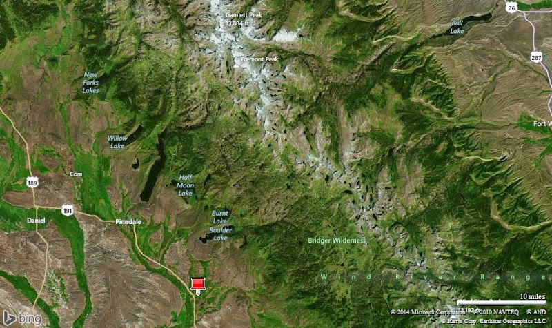
Gannett Peak, elevation 13,804 feet, is the highest point in Wyoming. The Wind River Range has 19 out of 20 of the highest peaks in Wyoming
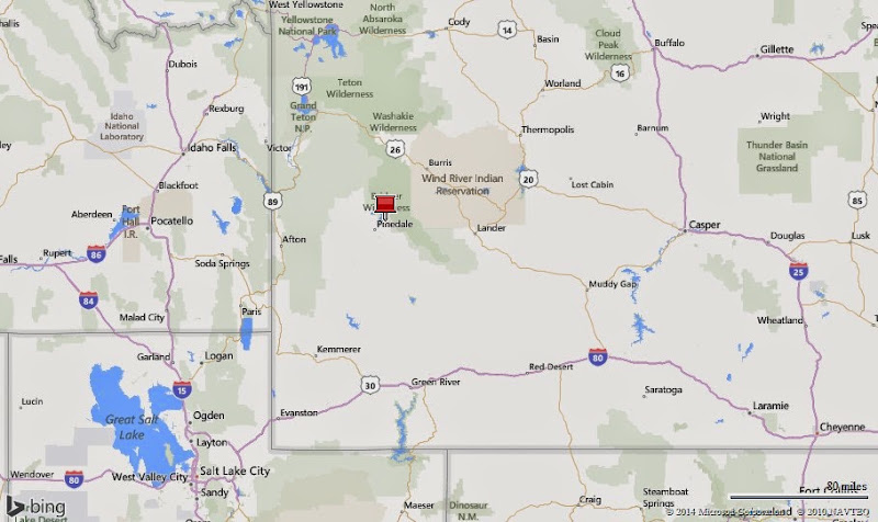
One month in Boulder and Pinedale, Wyoming…

First stay in Wyoming…Arleen adding the sticker
Why we came…
We came to explore the spectacular Wind River Mountain Range. With hundreds of miles of trails and hundreds of high alpine trout lakes, it’s a our kind of paradise! Unfortunately, due to a harsh winter, we were at least two weeks too early. Deep snow and high runoff significantly impacted our plans, but we still did a lot.
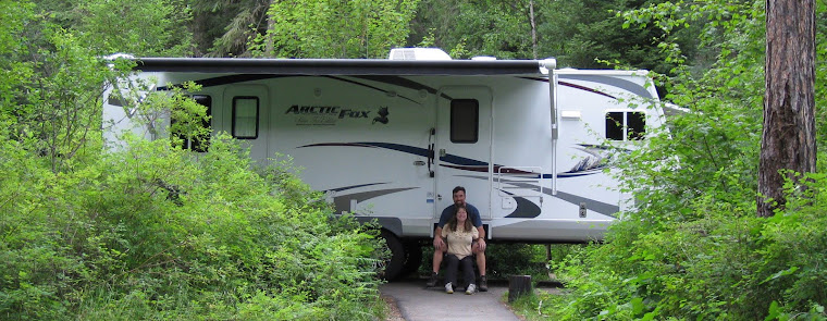
The campground…
Highline Trail RV Park is in Boulder, Wyoming, a tiny community of about 75 people located 15 miles southeast of Pinedale (the largest town in Sublette County with about 2,000 people). Highline is a rare private park with huge campsites…we had plenty of space! Sites were long, wide, level gravel with just a few sparse medium sized trees. Satellite reception should be good in all sites. The cell phone signal varied considerably from occasional weak 4G to just about nothing. The wi-fi also varied considerably with usage…at times it slowed to a crawl. Everything was very well maintained, and though the two washers and two dryers were a bit old, they worked fine and cost just $1 each…a bargain compared to most campgrounds! Roughly a third of the sites were occupied by long term residents, mostly gas and oil field workers. Most of the long termers keep tidy sites. The workers all had big diesel trucks that roared to life most mornings around 5:30 or 6:00. Thankfully that’s about the time we woke up so it didn’t bother us too much. Otherwise, our site was a ways off the main road and peaceful. Debbie, the manager, did a great job of keeping things clean and everyone happy. John, the owner, worked his butt off to keep everything functional and looking nice. John was a wealth of information and a lot of fun to talk to. By the time we left, he was a friend. We liked Pinedale; we liked the campground; and we loved the Wind River Mountains…we would gladly come back!

Our home with a small portion of the Wind River Range in the background

Afternoon thunderstorms…cool!
Adventures…


Tried to hike from Half Moon Lake to Fayette Lake / The osprey has a lake trout in its talons
On 27 May we planned a 10 mile hike route to check out Half Moon Lake, Fayette Lake, and Little Half Moon Lake. Pole Creek, flowing into Half Moon Lake, was a raging torrent. We stood on a 30 foot high cliff looking straight down at a huge eddy circulating 2 or 3 whole trees around and around…it was impressive. Each drainage was frothing whitewater and overflowing the banks and kept forcing us to the west of our planned route. It was tough off-trail hiking through glacially gouged terrain. We gave up after spending too much time and energy and never made it to the lake. We saw tons of moose poop but no moose. I fished the lake’s inlet for a half hour and got skunked.


Pole Creek was a raging torrent…the trail was supposed to cross it…NO WAY!

Fishing Half Moon Lake where Pole Creek enters…got skunked

Arleen fishing Soda Lake
On 28 May we checked out Soda Lake. We wanted to get the kayaks on the water, but the winds were too strong. Soda Lake has a yo-yo history of having good fish for a couple of years and then crashing for a couple of years. The lake has a ton of scuds so there is plenty of food for the trout. However, it has no inlet or outlet so it can get too alkaline. Rumor has it that Soda Lake “is coming back”. I caught one fat brook trout and broke off another nice fish. It was tough to fish from the bank because it’s shallow. We really liked the view of the Wind River Mountains, especially impressive Fremont Peak.


Fighting a fish at Soda Lake / A fat brookie…My first Wyoming trout!

Arleen fishing Meadow Lake with an ominous cumulonimbus mammatus cloud nearby
On 29 May we checked out Meadow Lake. It has a reputation of being the best arctic grayling lake in Wyoming!
Like many of the lower lakes near Pinedale, the route is on a long dusty dirt road. The last five miles has some short, but really rough sections best suited for a high-clearance four-wheel drive vehicle. The sky was ominous, but we launched our kayaks and paddled towards the lake inlet. I hooked a couple of pretty grayling right off the bat! They were 10-15 inches long and I admired their psychedelic colors. The winds were picking up so we paddled to the opposite side and fished the lake’s outlet. I caught at least 10 more before the wind got to be too much. There was a whole family of ospreys fishing too. We saw at least five spectacular dives. After one successful plunge, the osprey flew low and slow over us dangling a grayling in its talons as if to say “nan-nie nan-nie boo boo”! It was so cool.


Arctic grayling…one of the prettiest fish / An osprey with a grayling snack


At the entrance to Green River Lakes / A nice rainbow trout
On 30 May we went to Green River Lakes. We got a report that the road was in decent shape and the ice had just melted. It was a 60 mile drive from our base camp in Boulder. The last 20 miles is wash-boarded dirt road and follows the Green River to its namesake lake. The closer you get to the lake, the more spectacular the scenery gets. As we crested the final little hill near the small boat ramp, we were blown away by one of the most beautiful scenes in America!
We hurried to launch the kayaks in nearly perfect conditions. As we paddled towards the lake’s inlet, just 30 minutes after we launched, 20-25mph head winds kicked up 1-2 foot waves…YUCK! We had to turn around. We stowed the kayaks and walked to the lake’s outlet. Like all of the other creeks and rivers in the area, a whole bunch of water was rushing out of the lake. Thankfully, there is a nice bridge for hikers and horses. It was also a decent place to fish and I caught a 16 inch lake trout and two nice rainbows in spite of the 30mph winds.
Green River Lakes is one of the most beautiful places in America. If ever in the Pinedale area, make sure to dedicate a day to see it!

Spectacular Green River Lakes and Square Top Mountain

Fishing the lake’s outlet


New Fork Lakes kayak route / Flowers blooming near New Fork Lake
On 31 May we fished and hiked near New Fork Lakes. Like Green River Lakes, the ice had recently melted off of New Fork Lakes making it the supposed prime time to catch trout. We launched the kayaks and enjoyed the three mile paddle to the lake’s inlet in perfect conditions. We fished the inlet hard for more than an hour and got no hits…it was disappointing. The paddle back got much tougher as a 20mph head wind kicked up. We floated right below an eagle that was perched near the top of a tree. New Fork Lakes is beautiful…too bad we didn’t catch any fish!
We sat in the truck, waited for a thunderstorm to pass, and then did a short hike. The trail skirted the west bank and was pleasant to walk. Instead of dropping to the lake’s outlet, we chose to stay on the ridge and climbed to a great view. The bright yellow flowers of the arrowleaf balsamroot were spread all over the hillside…it was stunning.

Arleen on serene New Fork Lakes


A bald eagle looking for a snack

Perched above New Fork Lake


Beautiful view of Freemont Peak from Soda Lake / A bald eagle
On 2 June we headed back to Soda Lake and didn’t catch any fish but enjoyed watching the birds.


Fayette Lake round two / Little Half Moon Lake, where we started
On 3 June we made our second attempt to make it to Fayette Lake and failed. We launched the kayaks on Little Half Moon Lake, fished for an hour, and then tried to find the trail on the other side of the lake. As we climbed, the trail got more faint and rugged. Our progress was slow and we gave up when the route ahead was too dangerous. The terrain around Fayette Lake got the best of us again! On the way back, I fished Little Half Moon Lake for another hour and caught a nice 18 inch brown trout that we ate for dinner. It was the first trout we killed this year and it was YUMMY!


Hike route around Elkhart Park / Too much snow on 5 June!
On 5 June we tried to hike from Elkhart Park at 9,200 feet down to Long Lake at 7,900 feet but there was too much snow. We also checked out some of the Pole Creek trail but had the same problem.


Blueberry Lake hike route / See the two marmots?
On 6 June we hiked to Blueberry Lake and caught three HUGE brook trout! The views of Boulder Lake were excellent and we saw some marmots. It was great to successfully hike to a lake!

Posing above Boulder Lake


Trophy brook trout about 20 inches long and 4-5 pounds! We released them…they should still be there!


Arleen with a pretty grayling / Talon marks likely from an osprey
On 7 June we went back to Meadow Lake and caught 30-40, 10-16 inch arctic grayling. The hits were so steady that we joked if we went more than 3 or 4 minutes without a bite! We really enjoyed watching the ospreys and eagles go after the fish and each other. I was more excited about getting the osprey and eagle pictures below than I was about catching the grayling!


The osprey, with talons out, tried to scare off the bald eagle


Avalanche debris at Middle Piney Lake / Fishing Middle Piney Lake…got skunked
On 9 June we explored Middle Piney Reservoir in the Wyoming Range west of Marbleton, Wyoming, about 45 miles from our base camp. Reports were spotty about the lake, but it has a good reputation for large lake trout and rainbow trout. We had heard that there was ice on the lake and that an avalanche prevented vehicles from driving up but we wanted to see for ourselves.
There were still a few patches of snow in the road, but the road wasn’t bad until we were stopped by an old rock slide less than a half mile from the lake. We backed up, parked nearby, grabbed our stuff and made the short hike to the lake. Sure enough, as we approached the lake, we saw tons of avalanche debris! Snow and ice were 10-20 feet deep and mixed with a whole bunch of timber. Some of the trees were thick, but broken like toothpicks…it was impressive. The debris field was a few hundred yards wide and ran into the lake. Nobody will be driving to Middle Piney Lake for awhile!
The good news was that the lake was about 60% ice free…a perfect time to catch trout! Walking the south bank was out of the question due to snow, but most of the north bank looked clear. Unfortunately, we were stopped by a steep snow field, but fished open water nearby. Floating timber and ice made it difficult to fish, but we gave it a valiant effort and got skunked. We were in the right place at the right time, but it didn’t pay off. Oh well, the weather was great, the lake was beautiful, and we even found a nearby geocache. Before we drove home, we stopped for a couple of hours to hunt for morel mushrooms in a burn area. Like the trout, the morels eluded us too. That’s alright…it was a great day!
If I lived in this area or were staying longer, I would keep a close eye on Middle Piney Lake. Due to limited access, fishing pressure will be minimal. Also, with the tons of timber the avalanche forced into the lake, there is more cover, nutrients, and food. All the little insects and critters that lived in those trees should now be trout food…grow trout, grow!

Panoramic shot of Middle Piney Lake…note the avalanche debris in the lake


Little Divide Lake hiking route / Arleen on the Scab Creek Trail
On 10 June we tried to hike to Little Divide Lake. The Scab Creek trail starts at 7,800 feet and our goal was 6 miles up the trail at 9,600 feet. Most of the climbing occurs the first two miles and then the route undulates up and down across the plateau. The first part of the trail was in good shape, but the snow covered more ground and got deeper as we proceeded. A tall lanky guy in his 60s caught us on the way up. He has been camping in that area since the late 90s. He shared a few stories and some good information…he was fun to talk to. His report for the trail ahead wasn’t encouraging, but he wanted to see if he could make it further than he did just a few days prior. He took off ahead of us at a brisk pace so we were able to follow his tracks. As we progressed, the trail roller-coastered up and down and the snow got worse. Initially, we easily followed the trail while punching through increasing knee deep mounds of snow. Just a quarter mile from our goal in a heavily wooded drainage, the trail disappeared completely under waist deep snow. It took us five hours to get that far… much longer than we had planned. We were soaked from the knees down and worn out. We stopped less than a quarter mile from the lake, refueled our tired bodies, and chose to head back… defeated again! We cursed the snow the entire way back, but made it safely. It was a tough day. We climbed about 2,500 feet and hiked roughly 12 miles, much of it in mud and knee deep snow.

Too much snow on 10 June!


Diamond Lake route on the Big Sandy Trail / See the elk?
On 13 June we hiked up the Big Sandy Trail to Diamond Lake. The Big Sandy trailhead starts at 9,100 feet and climbs slowly for six miles to Big Sandy Lake at 9,700 feet. The trail parallels the Big Sandy River maintaining mostly a south aspect which helps melt snow. Much of the trail was muddy, but we encountered very little snow…yay! Just two miles or so from the trailhead, the route wanders through a glorious open meadow along the river with a great view of impressive peaks. There were more meadows with tempting stretches of stream, but we pushed to Diamond Lake. The small nine acre lake, at 9,500 feet, is reputed to have cutthroat trout. It was a beautiful lake, half lined by an open meadow and half with pine forest. I thoroughly fished the lake for an hour and a half with both flies and lures, but saw no signs of fish…skunked again! That’s alright…we enjoyed the hike and the scenery and it was the first time we made it to one of the higher lakes. It was a success!

Fishing Diamond Lake in the Wind River Mountains…got skunked


Hiking up the Big Sandy trail with a 40 pound backpack / Camped at Big Sandy Lake
We spent 19-21 June tent camping at beautiful Big Sandy Lake.
The last few days of our one month stay in Pinedale we were FINALLY able to backpack to a high alpine lake! The report from the local outdoors shop was that the trail was in decent shape to Big Sandy Lake in spite of 6-10 inches of recent snow. We decided to load up our backpacks and spend two or three nights camped by the lake.
There was still a couple of inches of the recent snow along much of the route and it was a muddy mess the entire way. We maneuvered across most of the swollen creeks without getting too wet but two of them soaked us up to our knees…it was soooo cold! It took us about two and a half hours to hike the six mile route that only had about 800 feet of total elevation gain. That’s not bad considering the sloppy trail and our 40 pound packs!
We found a sweet camp spot overlooking the lake and set up the tent. Then we explored and found six more good campsites and a good-sized bear proof steel box… a nice surprise! Instead of hanging our “smelly stuff” in trees, we could store it safely in the container. This area is quite popular in the summer, but we had it to ourselves! Arleen prepared a backpacking meal with hot tea and we relished the special experience. After about 8pm the winds calmed and the rise rings of feeding trout started to appear on the lake. I caught six or seven little (4-7 inches long) but colorful brook trout and missed a bunch more. We watched the sun’s evening glow crawl to the top of the surrounding peaks and the sky turn purple and pink in a beautiful alpenglow. The memorable scene will be etched in our memories forever!
It was cold that first night, definitely below freezing, but we stayed fairly comfortable. We dreaded each time we had to crawl out of our warm sleeping bags to relieve our bladders! In the morning we let the sun warm things up a bit before we started our day.
Our plan was to hike up to Clear Lake, scamper over a small hill, and drop down to Black Joe Lake. Black Joe Lake is known to have nice cutthroat trout, but at 10,200 feet and in a narrow east to west canyon, snow was expected to be a problem. First, we had to make it to Clear Lake at 10,000 feet.
Much of the trail was on a southwest facing slope and timbered. There was quite a bit of snow and the trail was difficult to follow but we made it to Clear Lake. We hoped to catch a few small brookies, but failed after a short 30 minute effort. Our goal was Black Joe Lake. The cross country half mile route would be tough, so we were anxious to get moving.
We climbed the south facing hill with little problem, but as expected the snow was DEEP on the north side. It was 4-6 feet deep and there was a cliff between us and our goal. I walked up the spine of the hill to see if it looked any better…nope! Then I walked down the spine a bit and spotted fish in the creek just 150 feet below us! The cutthroat trout likely hadn’t been harassed by fishermen since last October. The further I walked down, the better the route to the creek looked. We tried to stay on top of the deep snow, but broke through up to our waists a couple of times. We made it safely down to a small section of the creek and spotted a couple of trout. Arleen made the first cast and immediately hooked a pretty 12-14 inch cutthroat trout! I put on a grasshopper fly and watched another pretty cutthroat hammer it. We hooked a few more and had a lot of fun. Because snow and high water restricted us to a small section of the stream and the route back was going to be tough, we only fished for an hour. Though it was brief, it was a special experience!
We scampered back up the steep hill and again stayed mostly on top of the deep snow. Once we crested the hill and headed down the south side back to Clear Lake, it was easy going. Now familiar with the route, the hike back to our camp site was much easier. Though we didn’t make it to Black Joe Lake, we made it to the creek and caught some pretty cutthroat trout. We considered our day a success!
As we were getting ready for bed that night, five young hikers set up camp about a hundred yards from us. After being alone the first night, we were a little disappointed to have company. It was cold again that night, but thankfully stayed above freezing.
Our goal the next day was Jackass Pass, elevation 10,800 feet. We wanted to see the incredible “Cirque of Towers” (another good link). We knew other hikers had recently made it so we were hopeful we could too. As expected the higher we got, the more snow we traversed. Unfortunately, we also had to navigate glacial boulders, too. About half way up the pass, just above North Lake, we cried “Uncle”! Cumulous clouds were brewing against a bright blue sky making the amazing scene even more incredible. We didn’t make it to our goal but we had another unforgettable day!
We decided to pack up camp and head home. As we gathered our gear, the sky got dark, and it rained lightly. Just as we stepped on the trail, we heard a crack of thunder! We made it back to our home around 7pm. We were worn out, hungry, and a bit grungy! We pampered ourselves a bit and eagerly tumbled into our comfortable bed…it was soooo nice!

A spectacular sunset our first night…and we were all alone


Hike route to Clear Lake and Black Joe Lake / A beautiful cutthroat trout

Fishing Clear Lake, elevation 10,000 feet

Incredible scene at Clear Lake…note the amount of snow on the opposite bank


At the top of the hill between Clear Lake and Black Joe Lake / The western end of Black Joe Lake


Black Joe Creek from the hill…can you spot at least 10 trout? / A nice cutthroat that hit a grasshopper fly

Fishing Big Sandy Lake


Jackass Pass hiking route / A marmot…our favorite alpine critter!

INCREDIBLE!


Too much snow on 21 June! / Posing near North Lake about a mile & a half from the pass

North Lake, elevation 10,100 feet, and War Bonnet Peak, elevation 12,191 feet

A spectacular view above Big Sandy Lake!
Misc…
On Memorial Day we drove to Lander, Wyoming to meet Arleen’s sister’s family. We met Mary, Kendel, Heather, and Stephen at Gannett Grill and had a great lunch. The visit was way too short because they had to hit the road for a lengthy drive back to Colorado. It was a fairly spontaneous meeting and a real treat! We also walked around Lander and found a few geocaches. On the way back to Boulder, we detoured through the historic mining town of South Pass City and we stopped at historic markers and learned about the Oregon Trail.


Memorial Day in Lander, Wyoming / Kendel, Mary, Arleen, Heather, and Stephen


Remnants of South Pass City / Population was 3,000 people in 1869 making it Wyoming’s 2nd largest town


A marker on the Oregon Trail / Up to 300 wagons traveled this route daily prior to 1869


Learning knots / Working on casts / Putting it all together
Arleen took a ladies-only fly-fishing class. 17 women attended the four hour course. It included lunch, and fishing on a private pond for just $25. She learned a few knots, got casting hints, and gleaned other good info. There was an accuracy and distance casting competition…She placed fourth and won a nice “Trout Unlimited” hat! That’s my girl!
Next…
We will spend two weeks exploring Grand Teton National Park…we are very excited!
Parting shots…


Freemont Lake…Wyoming’s 2nd largest natural lake / Arleen flying in the wind above Freemont Lake


Momma pronghorn with two youngsters / Pronghorns back-dropped by the Wind River Mountains

View from my chair…Fremont Peak, elevation 13,743 feet, 3rd highest in Wyoming

Evening reflection on Big Sandy Lake
(54,200)