
Four days in Crystal Beach, three days at Goose Island State Park, and five days in San Antonio
Crystal Beach TX …Why we came…
To experience the Texas coast.

Now we have camped in Texas!

The campground…
Crystal Isle RV Park was decent. The sites in the back half of the park were privately owned and the ones towards the front half were for transients like us. The sites were pretty close together, but we were fortunate not to have neighbors. We had full hook-ups, a strong cell phone signal, and ok wi-fi. The sites were fairly long, fairly level, and a mix of grass and gravel. Half of the transient sites back up to a small canal and the other sites back up to a busy shipping channel. Though the sites on the shipping canal had front row seats to huge ships cruising by just a hundred feet away, those ships are noisy so we were thankful to be backed up to the small canal. Speaking of noisy, grackles, a bird with a loud and annoying shrill siren-like call, were very active all around us, especially around sunrise. We wouldn’t have been able to sleep in if we wanted to! Additionally, a large group camped on the other side of the canal had a noisy dog, played fairly loud music, and were a bit rambunctious. Though the RV park wasn’t too peaceful, we were pretty comfortable.
There are a number of RV parks along the Bolivar Peninsula. They are all pretty similar, but most of them are right along busy route 87. We chose Crystal Isle because it was a half mile off the main road and because it had a boat launch. Our initial plans were to kayak and experience the rumored good fishing, but we kept the kayaks out of the water and didn’t buy a Texas fishing license.
The access street to the RV park went through a varied and rough area. Along the half mile road were some nice vacation homes, a couple of dilapidated RVs and mobile homes, a couple of nice RVs and mobile homes, and a few very rough houses surrounded by decades of junk and old cars. This was normal across much of the Bolivar Peninsula. However, the ocean side of route 87 was nicer with more vacation homes.
It’s unlikely that we would go back to the Bolivar Peninsula, but if we did, we’d probably stay at Crystal Isles again for the boat ramp. We’d like to experience the fishing, otherwise the area doesn’t offer us much.


A private canal is behind us that leads to a major shipping channel
The Bolivar Peninsula, has five small towns totaling a population of 2,417. During our stay, it was quiet during the week and a zoo on the weekend. Folks from Houston inundate the area and the long wide beach becomes a big party…not our thing.
Hurricane Ike, a strong category two storm with sustained winds around 110mph, made landfall on September 13, 2008. A 21 foot high storm surge with powerful gale driven waves roaring on top, destroyed nearly all buildings and significantly reshaped the narrow peninsula. There are some older buildings on the bay side of the peninsula that still sit idle with hurricane damage, but otherwise, visitors today would never know it happened.

“The Big Store” is the main place to shop for supplies and food on the Bolivar Peninsula
Galveston, population 47,743, is 17 miles to the southwest and easily accessible by a free ferry. Though the Bolivar Peninsula has places to get supplies (mainly “The Big Store”), Galveston likely has items that aren’t available nearby. The Galveston/Port Bolivar Ferry runs 24 hours a day. Up to five ferries run simultaneously during busy periods. The ferry was convenient, easy, and free…a great combo!
Hurricane Ike spared Galveston a direct hit, but the “Great Galveston Hurricane of 1900” didn’t. The category four hurricane made landfall on September 8 with sustained winds of 145mph. An estimated 8,000 people were killed and most structures were destroyed ranking it near the top of the worst natural disasters to hit the U.S. Today, Galveston is a vibrant city with few lingering reminders of multiple hurricane strikes.
Adventures…
On 24 March we walked a portion of the beach…
It was uncomfortably breezy and a bit chilly, but the sun shown brightly so we set off for a long walk on the beach. We knew the parking near the beach required a parking pass so we parked at the library and walked the half mile to the beach. As we got closer to the beach, it looked like the NBC peacock had been hired to paint the beach houses. They all looked fairly new, vibrant, and were elevated on stilts. They contrasted sharply with the homes along the canal that were older, weathered, and dreary.
As we started to walk along the beach, we were surprised to see vehicles cruising the beach! Speed limit signs of 15mph were posted but most folks went double that. We had to keep a wary eye open unless we walked in the softer sand near the waves.
Due to days of a strong southerly wind fetch, there were good waves breaking on shore. As we always do, we took time to appreciate the pelicans playing with the waves. In addition, we could see numerous freighters and oil tankers back-dropped by the city of Galveston. We also noted a few spring breakers who, despite the chilly temperatures and winds, were determined to get their tan time in, shielding themselves with their vehicles. We saw a few fishermen but did not see anyone catching anything.


Hike route along Crystal Beach / Arleen on this home’s swing. Nearly all houses are built on 20 foot high stilts for hurricane protection

The beach is wide and miles long. It’s open to vehicles and has a party atmosphere on crowded weekends.


We like watching birds along the beach

Surf’s up! Galveston is in the distance.
On 25 March we walked around Fort Travis and then hopped the ferry to Galveston…
Old Fort Travis is on the western end of Bolivar Peninsula, a strategic entry point to the Port of Galveston. For this reason it was constructed for protection of the Port in 1899. It was decommissioned in 1949 and then later purchased by the Galveston County Beach and Parks Department in 1976. It is a very scenic county park with a few camping spots and several picnic areas in addition to some of the remaining fortifications.
On our first walk lap, we studied the interpretive signs and learned about the history of the Fort as well information on local flora and fauna. We noted that on our second lap, a number of families had parked near our truck and were joining us in exploring the interesting park. On our third lap, we met a large group of birders that return and reunite there every year. We so enjoyed strolling around the park, we returned the next day and did four laps.
There was no fresh fish at “The Big Store” in Crystal Beach. When I asked, someone recommended Katies’s Seafood Market in Galveston. It was only a short, free, ferry ride away. Since we had toyed with the idea of taking the trailer on the ferry on move day to avoid Houston traffic, this provided us a perfect reci mission opportunity! We pulled up and were immediately loaded on the ferry! It went very smoothly.
After getting off the ferry, it was only a five minute drive to Katie’s. They had fresh Red Snapper, our favorite Gulf fish. The gentleman, who assisted me, let me pick my fish and then skinned and filleted them for me. Perfect!


Walk route around Fort Travis / Feeding egrets are common around marshes

Part of the old fort and the Bolivar Peninsula lighthouse

Just a couple of the large ships anchored in the Galveston channel

Three of the Galveston ferries


On the ferry to Galveston / Fresh fish for us!
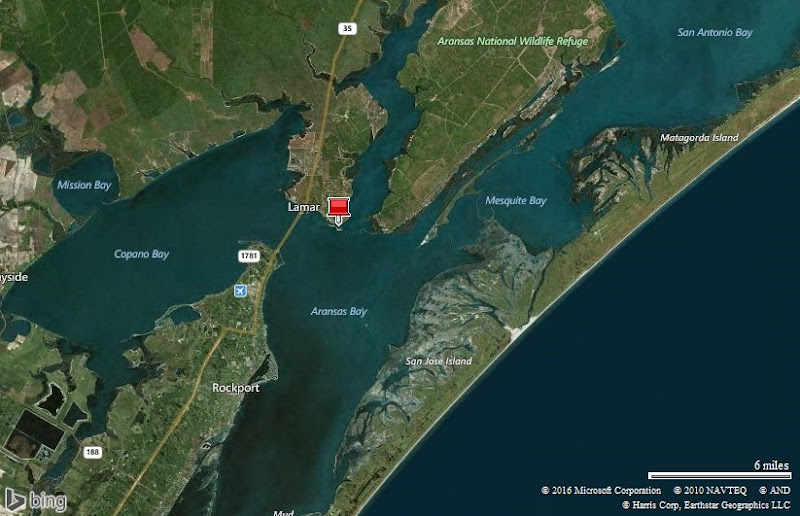
Goose Island State Park …Why we came…
To see more of the Texas coast.
Ferry ride…
We awoke to a very foggy morning and wondered how it would affect our ferry ride. We hitched up and knew the answer as we pulled up to the ferry at 9:00am and three lanes of vehicles were waiting. We estimated the visibility to be about a quarter of the mile and theorized that they limited the number of ferries running based on visibility. During the hour and a half we sat there, we only saw one ferry operating.
We could hear fog horns moan softly in the milky soup, but couldn’t see anything. Finally, the visibility markedly improved to at least a mile. Sure enough, two different ferries started to load up. We drove the truck and trailer onto the ferry with assistance from a ship hand. It was a snug fit and a little nerve wracking, but not bad.
As we moved out into the gloom, we would get glimpses of tankers moving just a few hundred yards off our port. It was a little unnerving. We took turns getting a view from the upper deck and from the top of our trailer. It was all good practice for the big ferry ride we will take to Alaska in a few years.


Our home is on the Galveston ferry!
The campground…
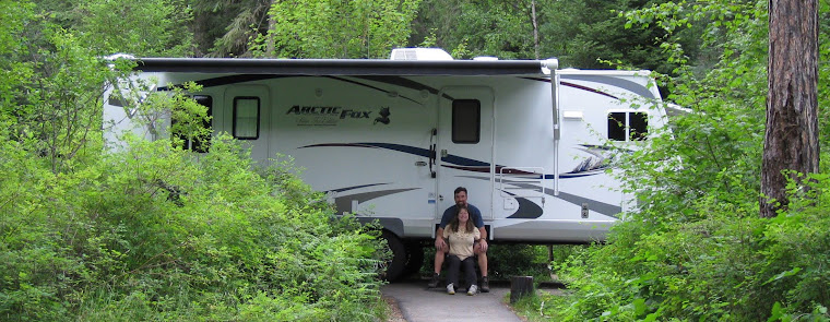
We liked Goose Island State Park! The are two camp areas: one on the beach and the other in the woods. There are pluses and minuses to both, but we chose a wooded site because they were bigger, had privacy, and were peaceful. Most of the sites had water and electric. There were two dump stations located conveniently on the way out of each camp section. Our site was long, gravel, fairly level, and hemmed in by trees. We did not have a cell phone signal or wi-fi. However, the beach campsites had a good cell phone signal. A big negative for the wooded sites were the numerous mosquitoes. The state park also had a long fishing pier and a boat ramp that would provide us with miles of interesting kayaking and fishing. We’d gladly return, but would stay on the beach for the great views, good cell phone signal, and most importantly, lack of mosquitoes!


Camped in the woods. Privacy, large sites, no view, no cell phone, lots of mosquitoes

The campsites on the beach. Close sites, no privacy, no mosquitoes, good cell signal, great views

Rockport, population 8,766, is 11 miles to the south of the state park. We only went into Rockport once for a quick grocery run. It seemed like a decent town with plenty of options for supplies, restaurants, and services.
Adventures…
Walks around the state park…
After we had set up, we went for an evening walk. The skeeters made sure we kept a good pace until we got out of the woods. We paused at the recreation hall to review the native plants display. We added the vibrant Coral Bean to our list of favorites. We were pleasantly surprised to see good clarity of the ocean water despite recent storms. It was the clearest water we had seen since Pensacola. However, they had an area that was called “Stinky Beach” named because of the odor of decomposing ocean vegetation.
Next, we checked out the Bayfront camp sites. They had smaller spaces with covered patios and great views. However, they would be open to strong winds. We enjoyed watching a variety of bird life though we did not see one Goose…Not sure how the park got its name. The sun set with a colorful display as we walked back to our home in the woods.
The next day we returned and went out on the long pier and explored the bird viewing area. We watched several kayakers out in St Charles Bay for a while. Many of them had found shoals to step out on and had leashed their kayaks to wade-fish the oyster bars. We smiled knowingly. The fishing looked very promising! We could return here someday.


A great blue heron and a great egret

Copano Bay Bridge at sunset


Hike route around Goose Island State Park / Stinky Beach got its name from the odor of decomposing vegetation

The fishing pier

You can access these shoals from the pier and wade fish the flats


A great egret looking for lunch in the marsh / An osprey hunting for a meal


American White Pelicans
The “Big Tree”…
It was another very windy and damp day so we visited Goose Island’s ancient tree. We both love old trees. Texas boasts that “The Big Tree” is one of the largest of its kind. In fact, it honored the tree with the title, “Texas State Champion Live Oak”. The tree is estimated to be 1,000 years old, measures eleven feet across the trunk, thirty-five feet around, forty-four feet tall, and eighty-nine feet across the crown. A number of volunteers take extra care of it, shoring up its long branches and make sure it gets plenty of water. We relaxed on a bench for a while and pondered what the old tree has experienced on the tip of Lamar Peninsula.


The Big Tree: 1,000 year old coastal live oak is 35 feet around.
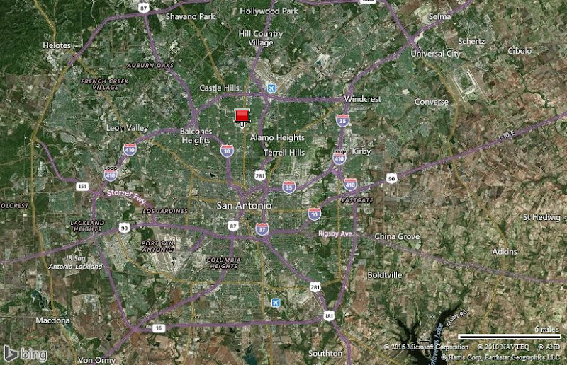
San Antonio … Why we came…
To visit friends, tour a few sites, and get work done on our trailer.
The campground…
We would not stay in a campground this time. Our trailer was having some maintenance issues and San Antonio was a perfect place to take it in for some service. Instead, we stayed at the luxurious Jim & Janet-Anne Gastehaus! While stationed in Germany, we were in the Mannheim ski club with Jim and Janet-Anne and traveled throughout Europe with them.
They had been very excited about our visit and extended an invitation for us to stay at their home. We were very comfortable in their upstairs suite. We took advantage of their laundry services and I was able to cook in a full size kitchen. We took lengthy hot showers and enjoyed fast reliable wi-fi. We took turns riding Jim’s “trike” and also soaked in their hot tub. Oh, we had it good! In addition, we were able to get some puppy love time with their poodles, Sugar and Spice. Most importantly, it was so good to catch up and visit with Jim and Janet-Anne. They were such gracious hosts. We really appreciate their hospitality and friendship.


Our wonderful friends and hosts: Janet-Anne and Jim
San Antonio, elevation 650 feet and population 1,409,019 with 2.3 million in the metro area (holy crap!!), is a busy metropolis area with plenty of things to see and do. We usually avoid big cities like the plague, but San Antonio was ok.
Adventures…
On 31 March we were treated to a surprise tour…
Janet-Anne had been teasing us about a surprise for a few weeks. We were eagerly curious to find out what it was.
We pulled into the San Antonio KSAT station parking lot, and were offered a small clue. We went in and met Adam Caskey, the local meteorologist, and the surprise became apparent.
Shawn had done the Armed Forces Network TV weather while in the Azores, so he was accustomed to a production studio, though not one of this size. For me, this was all new. Adam gave us a tour while the three of us shared stories of changes in the meteorology field, memorable storms, and the challenge of pleasing the public.
Next, he took us into the sound stage where the news was in progress. After it wrapped up, we met news anchors, Leslie Mouton and Mark Austin. They were very gracious and let Jim snap pictures of us with them. Finally, Adam presented us with one of his hand made thermometers. He has a shop in his garage where he blows the glass, calibrates the thermometer, cuts wooden Texas forms, and paints them. Janet-Anne and Jim pulled off a great surprise for us and we enjoyed the unique opportunity!


TV meteorologist Adam Caskey explains how he does his job / The channel 12 news crew
On 1 April Kelly took us to the Quadrangle and the Botanical Gardens…
Kelly and I were best friends through four long winters at Eielson AFB near Fairbanks, Alaska back in the ‘90s. As often happens, we have seen very little of each other over the years.
It was a joyous reunion at her house. I was happy to see her daughter, Sierra, and to meet her granddaughter, Finnley. Finnley had a great time showing me her room and introducing me to her toys.
Kelly, a San Antonio native, took us to a few of her favorite sites. First, we visited Fort Sam Huston’s Quadrangle. It was built in 1876, serving as a supply depot. It is still utilized by Army North to this day. Kelly told us a fabled story of Geronimo’s brief stay at the fort.
“The nomadic Geronimo refused to eat any of the food the soldiers prepared so they brought animals to the court yard for him to hunt. The ploy was successful and Geronimo and his band were happy. The deer and the birds remain as inhabitants of the Quadrangle to this day.”
Kelly brought a bag of greens, apples, and carrots. The two of us had a great time feeding the peacocks that followed us everywhere as we tried to feed the deer, ducks, and geese.
Next, we drove to the San Antonio Botanical Garden. We were all hungry and knew that the historical Carriage House served a highly rated lunch. Getting seated outside in the garden enhanced the delicious experience! Afterwards, we wound in and around the immaculate garden.
We learned a lot at the “Water Saver Demonstration Area” on “responsible landscaping with plants suited to our climate”. When we have a house again someday, we agree that we want to go with a low maintenance plant landscape rather than a lawn.
Our favorite area was the Texas Native Trail which imitated a “walk across Texas”. It displayed extensive flora collections representing the three distinct regions of the state. Here, I saw another addition to my favorite flower list; the Texas Pink Primrose. There were really nice displays of the Texas state flower, Bluebonnet. This member of the lupine family has been on my favorites list for years.
It was a perfect day with Kelly and we look forward to seeing her again someday.


Feeding the birds at the Quadrangle. The tower was built in 1877 to house a water tank. Geronimo and his band stayed here briefly in 1886. Stories of Geronimo jumping from the tower and deer being brought to feed the Indians are interesting, but likely false.


Feeding a peacock and a deer / Colorful koi

Arleen and Kelly back-dropped by Texas Blue Bonnets at the Botanical Gardens

Turtles at the Botanical Garden
On 2 April Al and Pon took us to the Riverwalk, the Alamo, a couple of Missions, and Lackland AFB…
We worked with Al in Germany 10 years ago. We met Al and his wife Pon at their home. A San Antonio native, Al was the perfect guide to take us to San Antonio’s most famous sites: the Alamo, the missions, and the Riverwalk.
He knew just where to park downtown and we set off on the Riverwalk. It is lovely! It is landscaped with brick and stone walls, vegetation, and waterfalls. As the trails wind around, it also takes you through shopping areas and places to eat. The trails have been expanded by many miles and would be perfect for a bike ride.
We turned a corner and saw the area’s first mission, Mission San Antonio de Valero commonly called the Alamo. It was founded in 1718, and just received the honor of being designated a Unesco Historical Site. We were shocked to see a line that reminded us of Disney. It snaked around and it took us about 30 minutes to work our way through it. We were then able to view the historic displays in the chapel. We also saw a collection of artifacts belonging to many of the Americans that fought and lost their lives daring the 1836 battle such as a musket belonging to Davey Crocket.
Next, we visited Mission Concepcion. We were really able to immerse ourselves in history here since the church is still in use today. Also, the grounds and other buildings have been well preserved. You can even see remnants of the original colorful frescos. “By combining the teachings of Catholic Spain with native cultures, mission life gave rise to the unique culture of modern-day South Texas.” Here we could see the connection from 1731 to present day.
We made a surprise visit to see Al’s Dad, who lives in the area. It was an honor to meet him and learn of Al’s younger years.
Finally, we did a drive through Lackland Air Force Base, where our military careers began. When we saw the overhangs of the barracks where we scurried to formation multiple times a day, it sent chills up our spines. It happened again when we saw troops marching in formation. Though we trained at Lackland over 25 years ago, it seemed like it was just yesterday!
We had a great day with Al and Pon. Pon is eager to travel to the Rockies and we hope she and Al will join us down the road some day for an adventure.


Dancing on the Arneson River Theatre stage / Our good friend, Al / Pon, Al, and Arleen at the Alamo


Scenes around the Alamo, built in 1744


Mission Concepcion, completed in 1731 / Arleen saying a prayer


Lackland Air Force Base is where we went to Basic Training / These buildings and those overhangs brought back a flood of memories

Brand new Airmen in Basic Training

Al Jr and Sr, 54 years of Air Force service
Next…
We spent five days exploring Big Bend National Park and are now camped at Brantley Lake State Park just north of Carlsbad NM. Our next stops are Bottomless Lakes State Park near Roswell NM, and then Albuquerque NM.
Parting shots…


Flooding on I-10 at the Louisiana/Texas boarder / A green anole at Goose Island State Park


Taking a spin on Jim’s trike in San Antonio

The sun sets through the oak trees at Goose Island State Park
(100,350)