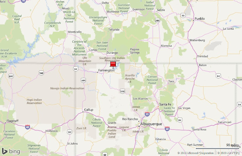


10 days at El Vado Lake State Park…

That’s me fishing El Vado Lake during a spectacular sunset. Life is great!
Why we came…
To fly-fish the Rio Chama below El Vado Dam and to explore scenic Chama NM.
The campground…
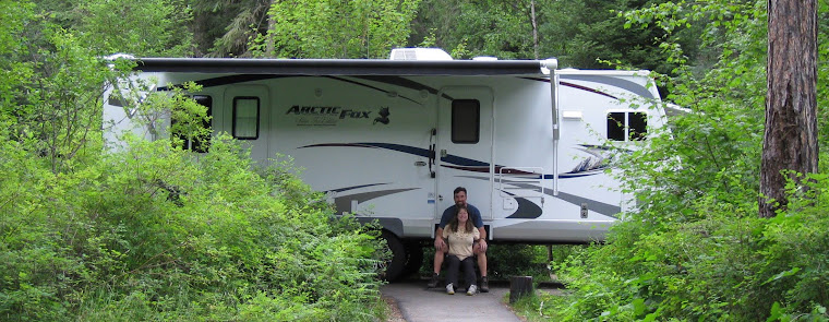
El Vado Lake State Park was nice. Our camp site was a back-in about 40 feet long and 25 feet wide. It was unlevel and composed of gravel and patchy grass. It would be sloppy after heavy rains. Our site was paired with another as were most of the 17 water and electric sites. Even with a neighbor, there is still plenty of room, but it would be annoying if your neighbor was inconsiderate. There was a covered picnic table and fire ring in each site.
We stayed prior to the official start of the summer season listed as 15 May so most of the facilities were closed. We enjoyed walking through closed campground loops and on maintained walking trails. We consistently saw wildlife: deer, geese, osprey, ducks, turkeys, and rabbits. In fact, 5-15 deer showed up each evening to graze in our back yard! There was no wi-fi and we barely had a cell phone signal. We flushed our tanks midway through or stay and again on the way out. The campground was nearly empty the whole time. It was one of the most peaceful places we have stayed! We had an outstanding view right from our a little home.
El Vado Lake levels vary considerably. We watched the lake rise about 10 feet during our 10 day stay…that’s a lot of additional surface acres in a short period! At one point there was 3,000cfs (cubic feet per second) of water flowing into the lake and 300cfs flowing out. We really enjoyed our stay and would eagerly return!

Looking northeast from the dam.

Looking northwest from the dam.

We had a great spot with an excellent view
Nearby towns…
There are multiple tiny towns like Brazos, Los Ojos, and Tierra Amarilla, within 20 miles of the lake. They offer very few supplies, groceries, and services.
Chama NM, elevation 7,850 feet and population 1,199, is 30 miles to the north and is the largest town within 50 miles. It has one decent grocery store, a quaint laundromat, a couple of gas stations, a few restaurants, and multiple RV parks. During the summer, tourists visit to ride the historic Cumbres and Toltec Scenic Railroad.
The area is an uncrowded outdoors paradise. There are multiple streams and lakes with good fishing and the hunting is rumored to be good. Snow sports would be fantastic during winter. Chama is the kind of place where “everybody knows your name” and locals take time to chitchat wherever they meet. We really liked it!
Adventures…
Fishing the Rio Chama…
The Chama River below El Vado Lake and Abiquiu Lake in northern New Mexico has steadily gained a reputation for quality trout fishing. After reading a few magazine articles, and surfing the web, we put the Chama River on our list of places to check out.
The river is small to medium by western standards and flows through some rugged country. In fact, 31 miles of river has been designated “Wild and Scenic” and flows, mostly inaccessible, through a canyon with cliff walls up to 1,500 feet high. The best way to explore the Rio Chama is a float trip. However this is limited:
“To protect the river environment from overuse, and to maintain an opportunity for a high quality experience, boating is limited to a set number of boaters per day. There is a lottery system to assign launch dates.”
Thankfully, the river is accessible just below the El Vado Lake Dam. Most of the property is private, but Cooper’s El Vado Ranch allows parking and access for $5. I started at Cooper’s each time and hiked two or three miles downstream to fish.
Initially the flow was just 75cfs (cubic feet per second), which is very low. I easily crossed the river multiple times as I worked my way down the scenic canyon. There were a couple of sections of trail that climbed above the river and along narrow cliff ledges. The elevated view of the river was great and I really enjoyed watching hundreds of cliff swallows leave their gourd-shaped nests and circle above the river to eat insects. I also enjoyed seeing geese, ducks, ospreys, ravens, and vultures.
And the fishing? It was fun! The low water forced most of the trout into the obvious runs and pools and made them more accessible to us fisherpeople. In spite of sparse mayflies, caddis flies, and grasshoppers, the trout fed entirely below the surface on nymphs. Size 16 bead head hares ears and pheasant tails dead drifted below a small strike indicator with no weight consistently got bit.
I caught 10-20 trout each day. Most were brown trout 12-14 inches long that put up great fights. I also caught a few “stocker rainbows” and one nice, brightly colored 17 inch long rainbow trout. The best trout I hooked were five browns that were 16-20 inches long. They were beautiful fish!
I saw no more than two other fishermen each day and had much of the pretty river to myself. It was a very enjoyable and peaceful place to fish…until the water flow nearly tripled…

Hike route along the Rio Chama below El Vado Lake

Rio Chama about three miles downstream of the El Vado Lake Dam


The cliff swallow nests are works of art / There was a white cross above this great fishing spot about three miles downstream


Trout food! / This 17 inch long rainbow trout hit a size 16 hares ear nymph, a rough imitation of the real thing

An average 14 inch long brown trout that put up a great fight

A beautifully colored 17 inch long brown trout. I hooked five browns that were 16-20 inches long.

Canada geese take flight with quite the ruckus


Once these little guys hit the current, they floated by very fast!
A tough hike out…
It’s important to keep an eye on water flow, especially during spring, and especially below dams where river flow is manually manipulated. I check the flow daily online and ask locals who often have inside information. Recent Intel indicated that the river should flow steady for at least a week and then get bumped up a bit.
On May 6th, I parked at Cooper’s mid-morning, and headed downstream on a beautiful day and eager to fish. The river was low (about 75cfs), and like my previous excursions, I walked back and forth across the slick-rocked stream with no problem and no concerns. I walked steadily for about 75 minutes, and stopped roughly three and a half miles downstream.
The river took a hard left and a good-sized island split the flow in half. There was a white cross perched on a rocky point about a hundred feet above the river. Below the cross was a very fishy looking run. I made myself comfortable on the island, drank some water, had a snack, and prepped my fishing gear. Other than various birds, I was completely alone and relished the peaceful scene.
The fishing was great! I caught at least 10 trout from that fishy run, mostly browns with a couple of rainbows mixed in. They hit consistently, fought great, and were all colored and patterned differently. I admired each one as I held them gently in the water and watched them swim off on their own. After an hour of good fishing, I took another break on the island and decided to fish my way back upstream.
I stopped at the next run and hooked two more, but the action had slowed so I pushed on. The steep rocky river banks forced me to climb a bit above the river and into the trees. I couldn’t see the river, but it sounded louder…hmmmm. Was it my imagination?
I worked my way to a rocky point about thirty feet above the water and was surprised at the view. The river flowed bank to bank, and looked like chocolate milk… Oh crap!
I stopped for a break and considered my predicament. While I snacked, a bunch of small debris rode the faster current down the river. I was a bit shocked when a mostly intact elk carcass floated by… Not good!
I was still about three miles from the truck, but thankfully, I was on the proper side of the river. The route back wouldn’t be easy. There were multiple obstacles along the way. I’d prefer to retrace my route, but that meant at least two river crossings.
My first option was to test the flow. I picked up a sturdy stick to use as a wading staff and carefully entered the water in a spot that I knew to be shallow. The current was strong and the chocolate milk colored water made the slick rocks invisible to me.
I proceeded very slowly, probing with the stick before every step. About half way across, the thigh deep water was flowing too fast for me to continue. Plus, it occurred to me that with one slip I’d end up somewhere downstream and it would take awhile for somebody to help me!
Crossing the river was no longer an option. Now I really knew that I was in for a tough hike back!
I walked along the river bank as much as possible, but was soon forced to navigate around a rocky cliff. Once I headed up, I decided to scramble a couple of hundred feet to the top to get my bearings. I had a great view of the river far below and the route ahead. Oh boy…the route ahead was quite challenging!
I half slid down a deer trail and followed it right back up to the next bench. Then the deer trail abruptly “T’d” at the edge of an impressive side canyon. I walked out to the point and looked for safe routes down, but they all sucked. I retraced my steps and walked along the top of the steep side canyon and spotted a couple of possible routes. After dropping into the canyon a couple of times and getting stopped by dangerous ledges, I finally found a half way safe route into the canyon.
The side canyon was pretty. An overhanging rock wall ringed most of the canyon, the kind you expect to find ancient cliff dwellings under. Below the cliff wall was a bunch of vegetation like scrub oak, pinion, juniper, ponderosa pines, cactus, and various types of flowers. I enjoyed walking down the dry creek bed, but my mission was to get out of there.
As I walked, I scanned the opposite canyon wall for an escape. My first attempt failed when it got too dangerous near the top. Then I spotted another deer trail. It was pretty steep with loose rock, but it worked! I got to the top, walked around the point, and saw the truck. It was just a fairly easy half mile away. Thank goodness, because I was out of water and thirsty.
Within 15 minutes, I was back at the truck. It took me about three hours to go three miles. I was in fishing waders and drenched in sweat from the waist down and quite dehydrated. I guzzled a liter of Gatorade and a liter of water that are kept in the truck for emergencies. I was back and all was well.
I never felt like I was in danger, and I felt strong until I got dehydrated at the end. I was also able to stay in contact with Arleen. I sent her a text message with my location roughly every thirty minutes.
Until the river flow increased, I was having a great day. Oh well. I got some good exercise and had a hell of an adventure!


Rio Chama flow above El Vado Lake / Rio Chama flow below El Vado Lake. Note the flow on 6 May.
Exploring Chama and Cumbres Pass…
It was a funky weather day so we headed into town to do laundry, get mail, buy supplies, and explore a bit. We picked up our mail and appreciated how friendly everyone was. Then we walked down to the train station and learned a bit about the railroad. The very small town center was pleasant and had a few tourist shops and a couple of restaurants. The laundromat was even quaint! After washing our dirty clothes, we headed back to the center of town and filled our bellies with some good Mexican food. It was barely one o’clock so we decided to drive north into the mountains.
We both remember Trujillo Meadows fondly from four years ago. The lake sits at ten thousand feet near Cumbres Pass and we had a successful time fishing for rainbow and brown trout. That had been in the fall season and we wondered if spring fishing would be even better!
As we drove north on Highway 17, the road immediately pitched up and we were enveloped in snow showers… It was May 7th! We slowed for the switchbacks, and began to see patches of snow. The trees changed from Ponderosa to our beloved Spruce, and the ground was more covered in snow then not. Our chance of seeing Trujillo Meadows faded.
We topped the pass, and could see feet of snow blocking the train’s way to the north. Just a half mile beyond that, more feet of snow covered the road to the lake. The mountain lake was likely locked in ice. We didn’t see the pretty lake, but were glad to be back in the mountains! The drive over Cumbres and La Manga Passes is one of our favorites.

Chama is a little quirky

The Cumbres and Toltec Scenic Railroad attracts a bunch of tourists during summer


Chama’s importance to the railroad / Cumbres Pass: “Altitude 10,022 feet, Railroad built 1880, Toll highway built 1881, Improved highway opened 1923”. The pass is very scenic and spectacular for fall colors.

Still quite a bit of snow near Cumbres Pass along the Colorado/New Mexico state line
Next…
We have spent a week in Red River NM and are currently near South Fork CO. Our next stops are: Johnson Village CO, Westcliffe CO, and Crested Butte CO.
Parting shots…


The yellow lab and basset hound greet everyone at Cooper’s El Vado Ranch. I parked here to access the river. / Deer visited us each evening in the campground.

Lightning over El Vado Lake NM
(103,000)