A month in one of our favorite places: Westcliffe, Colorado!
Why we came…
To hike and fish the high alpine lakes in the Sangre De Cristo Mountains.

We love the Sangre De Cristo Wilderness!
The campground…
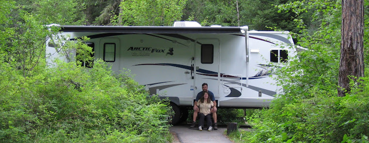
Grape Creek RV Park is excellent! The owners, Sandy and Mark, work their tails off to maintain everything and keep everyone happy. The long, gravel, pull-through sites are specious and nicely landscaped. We love to hear the aspen leaves rustling in the wind. We also love the incredible view of the spectacular Sangre De Cristo Mountains. We had decent wi-fi, and a weak but fairly steady 4G Verizon signal. The cell phone signal was spotty across the expansive Wet Mountain Valley and nearly nonexistent in town. There were two washers and two dryers, moderately priced at $2 each. There is almost zero road noise and it was very peaceful. Grape Creek RV Park, the Wet Mountain Valley, and the Sangre De Cristo Mountains make up one of our favorite places on the planet!

The RV park is in a beautiful setting

Camped next to my parents…we were very comfortable
Nearby towns…
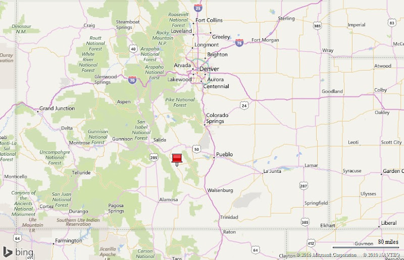
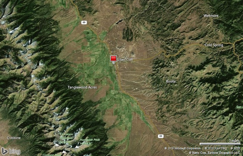
Westcliffe and Silver Cliff, or “the Cliffs”, have a total population of almost 1,200. There is one small, but well stocked grocery store, a good-sized True Value, a couple of gas stations, and roughly 15 restaurants. The twin towns sit in the expansive and scenic Wet Mountain Valley at an elevation of nearly 8,000 feet. The spectacular Sangre De Cristo Mountains jut up nearly vertically along the west side of the valley to heights over 14,000 feet. The mountains have good access with multiple trail heads and many miles of trails. Most of the trails end at gorgeous lakes set in high alpine bowls. Westcliffe is a charming little town. We love the area and would consider settling there!


Westcliffe is a charming little town


The small grocery store has a surprisingly good selection / The short tourist season results in a high turnover of businesses, homes, and land
The main supply towns in the area are Salida, 50 miles northwest, and Canon City, 50 miles northeast. Both towns have a Walmart, a couple of other grocery stores, a couple of good hardware stores, a selection of restaurants, and a small hospital. Both drives are very scenic, but along narrow winding roads with a chance to hit critters (like deer). It’s a good idea to slow down and enjoy the drive!
Adventures…
On 12 June I went fishing with my dad…
We headed northwest of Westcliffe to County Road 198. CR 198 turns into a 4-wheel drive road that zags up to popular Rainbow Lake. Our goal was the lower lake: Balman Reservoir. Unfortunately, the road was too rough with rocks and boulders the size of basketballs. We did an eight point turn in a tight space to turn back just a mile short of our goal.
Plan “B” was to check out Deweese Reservoir, a few miles northeast of Westcliffe. Since it was Sunday, it was a zoo. Deweese is a very pretty and cool weekend escape for the Colorado Springs/Pueblo crowd with jet skis and motorboats towing water skiers. We don’t care for the ruckus associated with the “adrenalin crowd”. In spite of the noise from barking dogs, loud music, and obnoxious toys, we fished for an hour and had just one hit.
Our next stop was Grape Creek below the reservoir. It was much quieter and the water plunging over the top of the dam was pretty and the sound calmed the nerves. The best part was we finally had luck with the fish. During our hour there, we hooked four nice trout on a size 16 red copper john nymph. I really treasure each fishing adventure with my Dad.


Field of flowers and the Sangre De Cristos near Deweese Reservoir / American White Pelicans


Dad fly-fishing Grape Creek below Deweese Reservoir / Hooked four nice rainbow trout
On 15 June we went to Lake Isabel…
Dad and Wanda love to camp and fish at Lake Isabel in the San Isabelle National Forest and the Wet Mountains. Besides pleasant summer weather at 8,600 feet, it’s an easy drive from their home in Pueblo West.
We pestered them till they agreed to take us and share one of their favorite places. We set out on a perfect blue bird day and wound through the scenic Wet Mountains getting a glimpse of Bishops Castle. We had visited the quirky structure with them 8 years ago.
“Lake Isabel is one of the few lakes in Colorado developed purely for recreation purposes. Built by the Civilian Conservation Corps, the lake attracts many campers, who come to hike, canoe, fish and spend time bird watching.” There is a trail that runs around 90% of the lake and it is fortified with railroad ties. A paved trail winds down to the lake from La Vista Campground making it very accessible to all levels of fishermen.
Shortly after we arrived, we hooked up our fly rods with our favorite lake fly: grasshopper. We had a good time watching the fish lips rise to softly sip in the hoppers. Though we hooked quite a few stocked rainbow trout, Dad and Wanda, the local experts, assured us that the fishing was slow. Gusty winds made fly-fishing difficult and may have affected our results. We finally gave up after a few hours and many shared fish stories and laughs.

Lake Isabel in the Wet Mountains


Wanda, Dad, and Arleen fly-fishing Lake Isabel / Wild irises were peaking around the lake

We had an enjoyable day despite gusty winds
Time with parents…
Fortunately, Dad and Wanda were able to get a camping spot right next to ours. We enjoyed walking around the campground with them, often with their little black fur kids, Chewy and Little Bit. We shared dinner together on the good weather evenings giving Arleen and Wanda an opportunity to get creative in their small RV kitchens.
Dad, rather than texting me, as he often does during the day, can just pop over. One of my projects was to replace our bathroom faucet. I was very happy to have my Dad there to supervise and give advice.
We went into Westcliffe together a few times, wandering around and popping in and out of the few stores that are still open. It is an adorable little town but businesses really seem to struggle when they only have five months of revenue.


Lounging at the campground


We gave Dad some goodies from our visit to Roswell NM / Another walk with “the girls”
On 18 June we attended Nephew Erin’s Ordination…
Erin, Arleen’s nephew, has been going to college for eight years in order to become a Catholic Priest. We both have a lot of respect for Erin and his calling. We had promised him years ago we would be there for him when he was ordained. In fact, we routed our summer plans to Westcliffe to be close to the event. The ordination ceremony was in Parker, Colorado.
We were both surprised when we arrived at the church 45 minutes early and the parking lot was already full. Mary, Arleen’s sister, said that 800 guests were expected to witness Erin, and his friend Sean, get ordained.
The elaborate ceremony included opening procession by the Knights of Columbus and Dames of Malta. Forty area priests participated while the Bishop of the Colorado Spring diocese conducted the Mass and presided over the ordination of Father Erin and Father Sean. Immediately after the ceremony, Erin and Sean proffered their first blessings at a reception.
That evening, the local parish church had a picnic just for Erin. We both had a great time catching up with family and friends and finally had a chance to chat with Father Erin.


Arleen showing her mom some computer stuff / My Mom’s “command module” / Leon and “the Devil Cat”

Erin and Sean being ordained Catholic priests


Father Erin and Arleen / Leon, Sandi, me, Arleen / Arleen, Ellen, Mary


Anne and Arleen / Ellen, Kathy, Mary, Arleen / Stephen and Heather

The family


A Father’s Day breakfast
On 20 June we finally hiked!
Arleen had been nursing a sore back for the last two months. In addition to back stretches and exercises, she recently had visits with a doctor, physical therapist, chiropractor, and acupuncturist. She was feeling better and anxious to do a real hike.
First, we casually drove up to the Grape Creek trail head, and then we “white-knuckled” it 2.5 miles further to the Music Pass trailhead. The four wheel drive section isn’t too rough but it is very narrow…not a good idea for a full-sized truck!
We chose to park a half mile short of the trailhead. From there it was an easy two mile hike to Music Pass.
As we crested the final few feet of Music Pass, elevation 11,400, the view over the Sand Creek valley and up to the jagged Sangre De Cristo peaks, blew us away. It rivals any national park! We spent some time there enjoying the incredible views and taking pictures. I had carried up a camp chair for Arleen and she settled in with a panoramic 360o view and a book…a fantastic place to relax and read!
I hiked the final two and a half miles to Upper Sand Creek Lake by myself. Initially, the trail drops about 600 feet to the creek, and then climbs about 800 feet to the lake. There was quite a bit of snow during the final half mile, but nothing too deep to stop me. I arrived at the scenic alpine lake, elevation 11,700 feet, and was surprised to see it still 40% frozen.
I shared the lake with just two other people that I could barely hear and see. I felt like I had it to myself!
Fishing is often good at ice-out. The trout haven’t seen fishermen for months and begin to gorge themselves during the short summer. Sure enough, the trout were hungry! I landed about ten brightly colored cutthroat trout on grasshopper flies. Two were beautiful 17” trout.
I kept a close eye on the sky. The clouds quickly grew more ominous and a few BOOMS reverberated off the peaks. I rushed down the trail to collect Arleen. She had also been concerned. She had a good cell phone signal from her perch and monitored radar for lightning. The storm dissipated about as fast as it blew up.
We hiked back to the truck under bright blue skies and eagerly discussed the next hike. Arleen’s back passed the first test!


Hike route to Music Pass and Upper Sand Creek Lakes / Hitting the trail

The view from 11,400 foot high Music Pass is one of the best!


Posing at Music Pass / Perched hundreds of feet above Sand Creek


Arleen’s reading spot


Bright afternoon sun shining through columbines / Snow covered much of the final half mile of trail to Upper Sand Creek Lake

Fly-fishing Upper Sand Creek Lake at 11,750 feet. The lake was still 40% frozen.


The cutthroat trout were still in brilliant spawning colors. I hooked 10 trout 13-17 inches long on floating grasshopper flies. It was a fantastic day!
On 22 June we hiked to Venable Falls and Venable Lakes…
Arleen had a day’s rest but was still nervous about a longer hike. We parked at the “Comanche-Venable” trailhead. It is an easy 20 minute drive on dirt roads from the campground.
The trail from the parking area to the Rainbow trail, and the first few hundred yards of the Venable Trail are a bit rocky in sections. Thankfully, after that, much of the trail is a fairly smooth and steady uphill climb.
Our first stop was at two and a half miles at the Venable Falls. The falls were engorged by spring runoff and stair-stepped down a narrow crevasse. We scrambled down the last 100 yards to get a good look. We were alone and really enjoyed watching and listening to the tumbling water. It was a special experience. I kissed Arleen goodbye and headed to the lakes by myself.
From there the trail pitched up and was rockier in places though, thankfully, there was very little snow. I was tempted to stop and try my luck at the meadow and beaver ponds. But the willows were thick and I wanted to see the lake.
The final stretch of trail pitched up steeply and wound through a stand of ancient bristlecone pines. We love the gnarled and twisted trees and wonder how they survive such a harsh environment. Too bad they can’t share their stories!
Shortly after I climbed above the bristlecones, I spotted two golden eagles soaring at the head of the incredible cirque. The impressive birds were majestic as they slowly circled to look for a snack.
The lower lake sits at 12,000 feet and had no ice. However, there were deep snowfields nearby and lining the west bank. I was entertained by numerous marmots. Some slept on rocks, some seemed curious about me, and some squealed and disappeared into their burrows.
I saw a few small trout rising but didn’t get any bites. I didn’t fish long. Thunderstorms blew up quickly. I raced back down the trail getting serenaded by booms echoing off the cliffs. I almost made it without getting wet but got drenched the final half mile. It was a good adventure for both of us. Though Arleen’s back was tight, she felt confident about doing a tougher hike.


Hike route to Venable Falls and Venable Lakes / Parts of the trail were quite rocky


Happy to be in the aspens / We really liked Venable Falls


Flowers near timberline / Venable Creek emerges from a snowfield / The variety of flowers is amazing

The trail goes between ancient bristlecone pines at 11,600 feet


I spotted two golden eagles soaring at the head of the incredible valley


Marmots and birds were my only company at the lake. In the third picture, both the marmot and I kept a close eye on the brewing thunderstorms.

Fly-fishing Venable Lake, elevation 12,000 feet. Saw a few small cutthroat trout, but didn’t get any bites
On 24 June we checked out Grape Creek and Deweese Reservoir…
We wanted to do another hike but we still felt creaky so we took it easy. We went down to Grape Creek where my Dad and I previously enjoyed the fishing. The fishing was still enjoyable, but the trout didn’t cooperate.
On a positive note, we met a nice couple. The husband was just learning to fly fish so we took the time to share tips with them. Then we drove back up to the lake.
Since it was a Friday, campers were arriving in earnest. Luckily, I found a good fishing spot on a rocky point while Arleen wandered off to explore and take photos.
I hooked two rainbows and landed one. Arleen, in the meantime found a newborn fawn that was still wet behind the ears. She kept her distance so not to startle it but close enough to capture a few images. She also observed the entertaining antics of several Abert’s squirrels.

Fly-fishing Grape Creek below Deweese Reservoir. Didn’t get any bites.


A brand new fawn! Arleen kept her distance / An Abert’s squirrel has a snack
On 25 June, Erin arrived and we hiked up the Cottonwood Creek drainage…
We really like that Erin, now Father Erin, Arleen’s nephew, tries each summer to visit us to get in some high country hiking. This day, he left the Front Range early and arrived by 7am so we could hike before the afternoon thunderstorms.
I had pored over the maps and spied the Cottonwood Creek drainage where we had never been. I decided it would be a good isolated wilderness experience.
We parked at the day use area on the high side of Alvarado Campground. The first mile and a half was a pleasant stroll on the Rainbow Trail. We peeled off on the Cottonwood Creek Trail and headed up for three miles and two thousand feet of climbing.
The very first part was a bit rocky and steep. Then, the middle part along the creek was nice, but a bit overgrown due to minimal usage…a good sign to us. Next, the upper part was a little steeper, rockier, and even fainter. We finally stopped at an avalanche shoot, elevation 11,300 feet, near the bottom of a meadow. The pretty meadow was loaded with old trees knocked down by past avalanches, knee high grass, a variety of colorful flowers, and a bunch of elk sign. The head of the cliff-enclosed cirque loomed ahead and it was a pretty place to enjoy fresh water and snacks.
Erin scrambled farther up a rocky slope while I fished Cottonwood Creek through the meadow. It looked promising as it meandered through the high meadow but I did not see any signs of fish. In the meantime, Arleen headed down knowing that Erin and I would catch up with her.
As expected the clouds built quickly into mature cumulonimbus, spewing rain, eliciting lightning, and clapping thunder. Erin and I hurried down and felt a few rain drops but stayed mostly dry. We caught Arleen and the three of us hiked out together.
Our bodies were a bit stiff the next day, but all in all, we felt good. This was a sure sign that we were finally in high country shape and Arleen was cleared for tougher hikes. Erin had been concerned about the altitude, having just come from the low altitudes of Italy. But he handled his 12,000 foot high scramble like a champ.


Hike route up Cottonwood Creek drainage / Erin and Arleen about to hit the trail

Columbines and Erin at 11,000 feet


Horn Peak, 13,450 feet high, towers two thousand feet above us / Cottonwood Creek meadow at 11,200 feet
On 27 June we hiked to Horn Lake with Erin…
We eagerly awoke on Monday morning looking forward to a longer hike and a return to my favorite lake from four years ago. We parked at the Horn Creek trailhead at the end of Horn Road.
It was a rocky half mile up to the Rainbow Trail and then a quick right and hundred yards north to the Horn Creek Trail. It was a steady, 2,800 foot uphill climb for five miles with just a few rocky and tricky sections. There were a few glorious sections of nearly level trail with no rocks through pretty aspen groves.
We were in the trees more often than not, so the view of the valley was limited but the shade was appreciated. There was one tricky creek crossing where we had to balance on a few logs. I added a few more logs and large rocks to add stability to the structure.
After the creek crossing, about a mile from the lake, the view ahead opened up of the rugged peaks and dramatic cirque. A carpet of wild flowers finished the perfect scene. At the same time deep snow banks lingered in the tree line we occasionally had to weave into. Fortunately, the snow was very compressed and we did not have post-holing issues.
When we finally reached the lake, we shed our packs, sat down and tried to take in the immense view. After a few snacks, Arleen enjoyed some yoga and stretches, while I headed to the lake with fly rod in hand. Erin spotted a tempting out cropping and quickly scrambled nearly 1,000 feet to the impressive perch.
Sadly, I only spotted a few small trout cruising around. Horn Lake is so clear which is one of the reasons it is so special. Unfortunately, it was very different than four years ago when I watched numerous cutthroat glide by within casting range. I halfheartedly tried several things but did not have any takers.
The clouds were building and it was soon “go” time. As we scampered down the trail and into the trees, we could hear the thunder reverberating in the cirque we had just left.
Arleen led the way. She slowly and deliberately headed down the rocky trail, focused on each step. Then I spotted a furry 200 pound creature less than 50 feet ahead of her, ambling up the trail. Like Arleen, its head was also down, snuffling from one side of the trail to the other! I clapped my hands and yelled, “Bear, bear”!
Arleen and Erin instantly looked up and saw its big fat black butt tear through the vegetation and up the side of the ravine. It quickly disappeared. Fortunately, that is the way most bear encounters end. Arleen joked that if I had not been there, she wouldn’t have been aware of the bear until it licked her cheek! The incident was a perfect opportunity to share other animal stories with Erin the rest of the way down. Though he probably heard our stories in the past, he seemed to appreciate them again.


Hike route to Horn Lake


These creek crossings are tricky / Parry’s Primrose flowers


There were still some deep snow fields along the trail


Some silly poses near Horn Lake


Doing some much-needed stretches / Fly-fishing Horn Lake…didn’t hook any trout


The arrow points to Erin. (Click the pictures for a better view.)
On 29 June we hiked to Comanche Lake…
Arleen and I looked forward to the return to Comanche Lake for its spectacular scenery and views. Four years ago I spied lots of decent trout but could not tempt them to bite. Would this year be different?
We took the quick fifteen minute drive to the Comanche/Venerable Trail parking area and headed left out of the parking area up the rocky half mile and crossing the Rainbow Trail.
The four and half mile trail climbs steadily with the first few miles in a mix of conifers and aspen. It always reminds Arleen of her first visit to Westcliffe and when she experienced altitude sickness near the top of this trail. Since then she has been well acclimated and has never had an issue again.
In the steepest area of this trail, there are several switchbacks carved into the hillside. They signal that we have climbed about half way to our goal 2,800 feet above the trail head. Shortly after that, the trail popped out of the trees with a great view both up and down the valley.
We climbed out to a perfect sitting rock to take a break. The views and flowers were incredible, especially the periwinkle colored Columbines. We could see clouds looming to the north and moving south. What else was blocked from our view by 13,000 foot high Spring Mountain?
I continued up the trail crossing two significant rock slide areas. As I crossed the second one, I felt rain drops splash my cheek. I took shelter among a cluster of trees. Fortunately, the soaking rain shower quickly passed to the south. But, it signaled that the air was unstable and alerted us to keep an eye on the sky.
When I finally reached the pretty little lake, I moved through the willows to get to the west side where the creek poured in. I saw that Arleen had taken a position on the east side to capture pictures of me fishing back-dropped by the incredible cirque.
I immediately spotted a couple of cruising trout and gently dropped my floating beetle fly about ten feet ahead of them. Sure enough, one of them accelerated and smacked my fly! Oh, yes, this was going to be a much better day than four years ago!
I fished for roughly ninety minutes and hooked about 15 colorful 13-15” cutthroat trout. I missed about that many, too. When the hits slowed, I switched the beetle out to a flying ant, then a hopper, and finally tied on a hare’s ear nymph as a dropper. With each switch, the trout resumed biting…it was fun fishing!
Arleen worked her way closer to take pictures from different angles. Then we noticed that threatening clouds were peaking around Spring Mountain again. It was “go” time.
We carefully hurried across the rock slide areas and down the trail. As we descended, we met a few folks on horses that were headed up. We warned them about the weather and they continued their climb. Shortly after that we heard a loud clap of thunder. It was not long before they came back the trail. You could see the determination in the horse’s eyes to get back quickly. We were happy to leave the thunderstorms behind, too.


Hike route to Comanche Lake


Columbines are one of our favorite mountain flowers

Looking east from about 11,000 feet

Comanche Lake


I had a great day of fishing!


Two very colorful, 15 inch long, cutthroat trout
On 5 July we hiked to Dry Lakes…
Four years ago, Arleen had turned back part way up Dry Lakes Trail. It is one of the shortest trails to a high alpine Sangre De Cristo lake but is also one of the toughest. Three sections of the trail have a thousand foot elevation gain per mile pitch and are quite rocky.
We parked at the Horn Creek trailhead. Arleen set off with a resolute look on her face to make it up the four mile, 2,900 foot strenuous route.
We kept a steady pace, taking care over the rocky sections. Like most of the trails in the area, there are a couple of short glorious sections through aspen groves. We appreciated the easy walking and were able to relax and notice the flora around us. Near the creek crossing we saw many new scars on the aspen trees from some members of the Cervidae (deer) family.
The last mile of trail popped out of the trees with good views but there was also an imposing slope to ascend. The last half mile was treacherous and steep with a lot of loose rocks.
Sadly, as I climbed the last few yards, 50mph winds hit me in the face. It was not going to be easy to fish. I made my way across the braided outlet to the east side of the lake and took shelter behind a boulder while waiting for Arleen.
She finally emerged near the lake and was exhausted but very happy to have conquered the tough trail! The strong winds really limited our options so we came up with a new plan while we rehydrated and snacked.
She waited behind the boulder and stretched while I made my way around the south side of the lake and navigated across a deep snow bank. I was sheltered from the strongest winds and made a sloppy cast. My grasshopper fly plopped onto the wind churned water and was smacked immediately by a small cutthroat trout. It didn’t take me long to catch four or five cutthroat on a hopper and dropper. Arleen took a few pictures of me but then focused her efforts on a friendly marmot.
I headed up to the second lake, and Arleen headed back down. She was eager to get out of the brutal winds and knew she would be slow to descend the steep, rocky trail.
I bushwhacked to the second lake, doing my best to stay out of the annoying willows. I climbed about a hundred a feet above the lake to scope it out. It was shallow and was going to be difficult to fish. However, I came this far and was determined to give it a shot.
Between wind gusts, I made a long cast over the knee deep water. I was surprised to get a hit right away! The fish there were just as cooperative and I quickly caught four or five more small cutthroat trout.
I caught up with Arleen a couple miles down the trail. Together we enjoyed the trail through the woods till we got to a rocky section. By then our legs were tired and it was a struggle to stay upright on the loose rocks. We were both very happy to sign out of the trail log and make it back to the truck.


Hike route to Dry Lakes


Another tricky creek crossing / Trees and bushes likely recently marred by elk

Braving 50mph winds to point towards our home at Grape Creek RV Park.


The boulder and depression provided a decent wind break / The Dry Lakes cirque is spectacular

Fly-fishing lower Dry Lake at 11,800 feet


Kings Crown flowers / A typical cutthroat trout from Dry Lakes / Arleen’s marmot friend

Me crossing the snow field to get to the next lake

Middle Dry Lake
On 7 July we hiked to Goodwin Lakes…
Four years ago we hiked to Goodwin Lake with Brian and Maggie. We missed their company but by the end of this day, we would have several new companions.
Although this hike is a total of 10 miles, it only climbs 2,400 feet. We took the quick fifteen minute drive to the Comanche/Venerable Trail parking area.
After the first rocky half mile, we turned right on the Rainbow and followed it for a mile, crossing a nice bridge over Goodwin Creek before turning left onto Goodwin Lake Trail. The first mile is a steady and rocky uphill climb.
I quickly left Arleen behind in an effort to increase my fitness. I reached a nice section through thick conifer/aspen woods and picked up the pace further. Then a huge cinnamon colored bear, only fifty feet ahead on the trail, kicked up a cloud of dust as it tore off into the woods! As I nearly peed my pants, I grabbed my pepper spray, made myself look big, slowly backed up, and told the bear to go away. It stopped about a hundred feet into the woods, barely visible, and stared at me. I continued to back down the trail, and when I could no longer see the bear, I put a marker in the trail and walked back to find Arleen, yelling and banging sticks against trees the whole time.
After I relayed the story to her, we sat down to take a break and give the bear an opportunity to move further away. We were relieved to hear several voices coming up the trail. “Safety in numbers” is a good philosophy with a known bear in the area. The voices belonged to four members of the Westcliffe Hiking Club: Becky, Steve, Dan, and Danny. They were amply armed and the six of us set off together.
Arleen and Becky immediately started sharing stories while the men shared stories with me. Steve, who knew the trail best, led us to a downed log that we used to cross the creek to avoid getting wet. Within a few minutes, we had a couple of reasons to be thankful for meeting this group.
We hiked to the lake together. We negotiated a few snow fields along the final half mile of trail above 11,300 feet.
At the lake, I stepped onto a good rock and spotted a cruising trout. I delicately dropped a small floating ant fly about 10 feet in front of it. The trout continued on its path and slowly came up to slurp in my fly. I reeled in the pretty 10 inch long cutthroat and posed for everyone’s pictures.
Arleen and Becky shared facts about all the wild flowers while trying to photograph their beauty against the lovely mountains. Steve, Dan, and Danny continued on to the upper lake. I continued to fish till they returned. I caught 10-15 cutthroat trout up to 12 inches long on various terrestrials.
By the time we headed back, there were at least 15 people gathered around the remote little lake. It felt crowded and lacked the peace of a wilderness experience…it was time to go.
We all hiked down the trail together. Arleen and Becky remarked that the rocky sections seemed shorter since they were so busy chatting. By the end of the hike we all seemed to be old friends. It will be a few more years before we return to Westcliffe, but when we do we look forward to hiking with our new friends again.


Hike route to Goodwin Lake / New hiking buddies: Me, Arleen, Becky, Dan, Steve, and Dan


Starting to get into snow / There was quite a bit of snow on this section


Arleen fly-fishing Goodwin Lake / A typical cutthroat trout from Goodwin Lake


Fly-fishing below a beautiful cascade / Numerous cutthroat trout hit our floating flies. It was very fun!
Hiking summary…

Satellite view of six of our hike routes
| Hike | Distance(Miles) | Total Ascent (feet) | Notes |
| Upper Sand Creek Lake | ~9.2 | ~2,575 | 2.5 miles of narrow 4WD road; Music Pass is spectacular; largest trout we caught |
| Venable Lakes | ~9.5 | ~3,100 | Steady uphill trail; liked Venable Falls; saw a few small trout; lots of marmots |
| Cottonwood Creek | ~9.25 | ~2,500 | Lightly used trail; lots of critter sign but no critters; saw no fish in meadow |
| Horn Lake | ~10.4 | ~3,000 | Enjoyable but lengthy route; spectacular cirque; saw few small trout; saw a bear! |
| Comanche Lake | ~8.5 | ~2,900 | A favorite! Enjoyable trail, great views; caught many above average size trout |
| Dry Lakes | ~9.3 | ~3,400 | Toughest hike with steep, rocky sections; caught many small trout |
| Goodwin Lake | ~9.75 | ~2,750 | Enjoyable hike; most snow; caught many average sized trout; had a bear encounter! |
| TOTALS | ~65.9 | ~20,225 | Amazing! |
Note 1. Stats include bushwhacking up and around lakes.
Note 2. Total Ascent includes all uphill sections which is usually hundreds of feet more than the difference between the lowest point and highest point.
General notes and observations:
- Expect to hike 8-11 miles and 2,500-3,000 vertical feet to get to the lakes. Add a few ups and downs and you will climb a total of 3,000-3,500 feet on many of the hikes.
- Overnight backpacking trips to the lakes would be more enjoyable than day hikes. It would split up the long hikes and provide more time to enjoy the lakes and good fishing, especially in the evenings and mornings when you are likely to have the lakes to yourself!
- The trails generally have moderate ascents of 400-600 feet per mile. Though some routes, like Dry Lakes, have sections that approach a 1,000 feet climb per mile.
- Trails alternated between relatively steep sections with lots of loose rock to glorious undulating sections through pretty meadows or groves of aspen. There was nearly always a source of water nearby that we could filter and drink.
- There was usually a spider web of faint trails near and around the lakes making it easy for groups to get separated.
- Lakes were difficult to navigate. The banks consisted of either large rock slides, thick brush, swampy marsh, or were very steep.
- Spots to fly-fish along lake shores were limited. Ideally there would be nothing behind you to snag your back-cast and a drop-off within easy casting range to fish. Wet wading with sandals would be great if you could tolerate the frigid water. The water might be warmer by August…I don’t know. A real motivated person could drag a pair of waders up to the lakes. We did fine from the bank once we found suitable places to fish. Just be aware that some lakes only have a few good spots to fly-fish. If people are in those spots, you will have a hard time fly-fishing.
- Critters…we didn’t see too many. We saw lots of deer, elk, and bighorn sheep sign, but never got a glimpse of any. We did see some interesting birds, a couple of harmless snakes, and a bunch of entertaining and sometimes bold marmots. We had two close encounters with bears, but bear sightings are rare based on trail register remarks.
- Weather…We experienced breezy, but mild and dry conditions, typical for June. Winds were often whacky at the lakes. There was no predominant wind direction and the speed would go from nearly nothing to 50mph. This would happen all day long, fluctuating every 15-20 minutes. Imagine calm winds, then a 50mph headwind, then calm, then a 50mph tailwind. It makes fishing frustrating, but wait a few minutes and it can be great. The temps at lake level were around 70F, but the erratic winds and any cloud cover made it chilly. July marks the beginning of the monsoon season in the southern Rockies. Afternoon summer thunderstorms are nearly always possible in the high country and must be respected!
- Ice out…In a normal year, ice melts off the lakes by late June. Above average snow and an extended cool, moist spring resulted in lingering snow fields for us. The trails were still safe and fairly easy to navigate.
Link to our Westcliffe blog from June 2012: http://mud-on-the-tires.blogspot.com/2012/07/co-westcliffe-15-28-june-2012.html

A Westcliffe wall mural depiction of the Wet Mountain Valley and Sangre De Cristo Mountains
Next…
We are currently playing near Crested Butte CO. After that, we will spend two weeks in Ouray CO, three weeks in Silverton CO, and five weeks in Pagosa Springs. Life is great in the Colorado Rockies!
Parting shots…

The Beckwith Ranch began in 1869 as a 160 acre homestead and grew to 3,000 head of cattle on 6,000 acres by 1874 making it one Colorado’s largest ranches


These signs mean that we are in for a true wilderness experience. No noisy, polluting, destructive toys allowed!
(107,450)