


10 days in Joseph, Oregon…
Why we came…
To explore the Wallowa Mountains!
En route Columbia Falls to Coeur d’Alene…
We started our final morning in Columbia Falls by heading to Les Schwab tires as they opened for business. We were very pleased that they only took about an hour to get new tires on our little home.
We headed south, retracing the route of our blowout 3 weeks before. Once again, we stopped in Plains at Ripples Ice Cream Parlor for a chicken wrap and ice cream lunch. They make creative wraps and their ice cream blends are delicious!
We decided to spend a couple of nights in Coeur d’Alene at Blackwell Island RV Park. It’s a large, but quiet RV park located on the shores of pretty Coeur d’Alene Lake with 182 full hook-up sites that average 60 by 40 feet. It has very a clean laundry room, bathrooms and showers.
They sell propane and have a mini-store. Plus they have a boat launch and moorage available. They rent 18' and 24' pontoons, canoes and water bikes.
We enjoyed the very nice walking trails with charming decorations that led to a few short private swimming beaches and relaxing beach chairs.
We had a pull through that was a level gravel site but we barely fit. They do have separate parking for vehicles that don’t fit in their site.
We had a reliable 4 bar, LTE Verizon cell phone signal. They offer free Wi-fi but we could never get connected. Satellite would work but since it was raining during our 2 day stay we didn’t connect and kept the equipment dry. The park offers 16 free channels of cable TV.
The RV Park’s location is convenient to grocery stores, big box stores, and restaurants. It is also within walking distance to the Cedars floating restaurant.


Campsite at Blackwell Island RV Park / We liked the trail that skirted Coeur d’Alene Lake
The Cedars Floating Restaurant is Idaho's premier floating restaurant, featuring upmarket locally sourced seafood and steak dishes plus regional wines. The Cedars, founded in 1965, floats at the confluence of Lake Coeur d'Alene and the Spokane River on a point offering a beautiful 270° view.
We were looking for someplace special to celebrate the equinox, fall, and our 12.25 anniversary. It was a quick walk to the unique restaurant. We were thankful for that because it was raining.
We had very good prime rib and salmon at early bird dinner prices. It included a great salad bar and Arleen had two free drinks provided by the RV Park.
We had to linger for a while as thunderstorms and a squall moved across lake. We enjoyed watching the wind-whipped waves from our comfortable spot.


We had a fantastic dinner at Cedars. We walked over in the rain and enjoyed watching a storm roll through.
Nearby towns…
Coeur d’Alene, population ~ 50,000 at an elevation of 2,188, is a scenic city in northwest Idaho. It traces its history back to the logging industry but now it is a top rated resort area. It is a fair size city with anything you would need plus many good restaurants. It is an outdoor enthusiast’s paradise with all sorts of water sports available on Lake Coeur d’Alene which is 25 miles long with boats of every size on it. In addition, hikers have easy access to the Canfield Mountain Natural Area and Coeur d’Alene National Forest. The city has a great trail system including the 72 mile long Trail of the Coeur d’Alene.
If you can’t find what you need in Coeur D’Alene, then Spokane, population ~ 215,000, just a quick 34 miles, will probably have it. In fact, we had to do just that when we had a taillight assembly burn out. RVs Northwest, the Northwood dealer in Spokane, was able to special order it and we picked it up and installed it the next day!
En route Coeur d’Alene to Joseph…
Linda and Dave, our NROA friends, had warned us that the drive from Lewiston to Joseph was tricky. They were right! First, there were steep uphill switch backs out of Lewiston. Then Highway 129 drops 1,800 feet over 7 miles with several hair-raising turns to the Grande Ronde River and then climbs steeply out. We nearly had the smooth road to ourselves and really enjoyed it!

WA Route 129 and OR Route 3 between Lewiston ID and Joseph OR are incredible.


Dropping into Lewiston ID / Washington Route 125 descends rapidly to the Grande Ronde and ascends again quickly. This is some rugged country! The road was narrow, nearly empty, and smooth. We really enjoyed it!
The campground…
Wallowa Lake State Park and the nearby Wallowa Mountains are fantastic! They’re no secret to Oregonians, but many people outside of the state have never heard of them. The jagged peaks rise from a base of around 4,000 feet to over 9,000 feet…they’re impressive! They also make up the rugged car free wilderness area: “The Eagle Cap Wilderness, at 361,446 acres, is Oregon's largest. Within these white salt-and-pepper granite mountains you'll find approximately 534 miles of developed trails and over 50 lakes to explore, including Legore at an elevation of 8,880 feet- Oregon's highest.” A primary trailhead into this area is south of the Wallowa Lake Village area. The region suits us perfectly!
The state park sits at the head of the pretty Wallowa Lake. There are five camp loops with a mix of full hook-up and no hook-up sites. The sites vary in length and orientation. Roads through the park and the camp sites are paved, though many of the sites are pretty unlevel. Even though it’s nearly October, the campground stayed more than half full. Other than a few loud campers and barking dogs, the place is absolutely peaceful at night.
We had full hook-ups, no wi-fi, and a very slow and unreliable Verizon cell phone signal. As usual with Oregon State Parks, everything was clean and well maintained. There were multiple bath and shower buildings, but no laundry facilities. Tall trees make satellite impossible from most sites. There was easy access to miles of hiking trails, the boat launch, kayaking, fishing, and touristy things in the tiny vacation town of Wallowa Lake. We really liked Wallowa Lake State Park and would gladly return.

The south end of Wallowa Lake. The campground is tucked under the trees on the right.


Wallowa Lake State Park and the Wallowa Mountains / Enjoying a warm fire / New snow fell about 1,500 feet above us

There were LOTS of deer wandering around the campground and town
Nearby towns…
Joseph, population ~1,100 and elevation 4,190 feet, is on the north side of Wallowa Lake about five miles from the campground. Joseph was originally named Lake City. However, the city formally changed the name in 1880 for Chief Joseph of the Nez Perce people. The population is just over 1,000 and sits at 4,190′ feet.
It is a cute touristy town with a decent selection of restaurants and a small grocery store. The laundromat was a bit expensive, but the machines worked well and were clean. Though Joseph is not in the Wallowa Mountains, it sits close enough that when standing on Main Street and looking up at the impressive peaks, it reminded us of Colorado mountain towns like Silverton…it’s very pretty!


Joseph, Oregon is quaint and pretty


Joseph’s City Hall / Various sculptures line Main Street


A ranch just east of town / Pretty red barn between Joseph and Enterprise
Enterprise, population ~1,900 and elevation 3,757 feet, is six and a half miles northwest of Joseph and has a few more restaurants and stores, including a nice Safeway.
We liked both Joseph and Enterprise. Not only do they have the slow pace of small towns, they’re in a spectacular part of Oregon!
La Grande, population ~13,000 and elevation 2,785 feet, is a 71 mile drive to the west. It’s the main service and supply center in the region.
Adventures…
On 23 September we hiked a portion of the Chief Joseph trail…
To hike the Chief Joseph Trail, you would normally take the West Fork trail at the Wallowa lake Trailhead. However, we wanted to start in the campground. So late one afternoon, based on the campground trail map, we hiked straight up from the west amphitheater.
We climbed over 700 feet in about a half mile on what was just a little more than a game trail. It exceeded our vertical limit. Once we hit the main trail, Arleen said that she was not going back that way.
We headed north for a few miles till we had a good view of the lake. It was a perfect spot to take a break and discuss our options.
We knew that the trail ended in a meadow in a saddle at the base of Chief Joseph Mountain at 7620’ feet. But we were pretty sure we had to hike to the south trail head.
The route back was a mess! We had to cross several rock slides, areas washed away in drainages, overgrown shrubbery whiplashed at our legs, and we had to clamber over giant fallen trees and duck under others. It was pretty challenging.
Finally, we arrived at the pretty falls that are the main destination for most folks. The BC Creek was swollen from recent snow melting above. Regrettably, the bridge was gone!
Someone had thrown some flat rocks in the middle of the existing creek rocks and a few narrow but long logs were added to make a dicey crossing. Arleen proceeded with caution knowing that the rocks and logs would be slick. She made it safely across and then I followed her. Here, we met a lone male hiker, the only person we saw on the trail.
From there it was less than a mile back to the trailhead. We found the trail vastly improved as we wound down a few switchbacks and crossed the West Fork Wallowa River Bridge. At the trailhead, we saw a notice that said the Chief Joseph Trail is NOT maintained. We laughed about this on our mile long walk back to the campground.


Hike route on the Chief Joseph trail / Looking across the valley to Mount Howard and the tram


Posing at our turn around point a thousand feet above the lake / Arleen crossing BC Falls

Crossing the West Fork Wallowa River bridge
On 25 September we hiked a portion of the Aneroid Trail…
The Aneroid Trail follows the East Fork of the Wallowa River.
“This steep trail accesses the main destinations of Aneroid Lake and Tenderfoot Pass. Its popularity is somewhat limited because of its arduous nature, making it the perfect trail for the fit and those who enjoy a little extra tranquility.”
We had a few hours one afternoon for a hike and knew that the Aneroid Trail switchbacks would be a great workout. In the first two miles, we climbed 1,000 feet.
We took a break at the bridge that crosses over to the Royal Purple Creek. As we headed down, we met a single female hiker with her energetic and happy border collie. She was the only person we saw that afternoon.
Near the bottom, we headed west on the horse trail to complete a rough lollipop loop.


Hike route up the East Fork trail / A pretty waterfall

Signs of fall in the Wallowa Mountains. Over a thousand feet above the lake.
On 26 September we saw the deepest gorge in North America…
We read that you could drive to Hat Point and look into Hells Canyon where the Snake River flows through the deepest gorge in North America. Well we had to see that!
From Joseph we took paved Highway 350 thirty miles to Imnaha, Oregon. Past Imnaha, we continued on Forest Road 2640. The road turned to a washboard that jiggled us to pieces on the first several miles. We also felt a little vertigo along the steep drop-offs.
“ADVISORY: Forest Road 2640 is very steep, and narrow. Low clearance vehicles, RVs and vehicles pulling trailers are advised to use caution when traveling the lower sections of this road.” We agree with that Advisory.
It took us over an hour to drive the 23 miles to a parking area about a mile and a half past the Memaloose Guard Station and Airstrip.
The Hat Point Day Use Area has paved trails that circle up to an old fire tower. We quickly climbed the 90 steps to get another 80 feet of height. From up there we had a fantastic view into Hells Canyon. We could see the Wild and Scenic Snake River and a series of rapids that were 5,750 feet below us.
Across the Canyon, the view was back-dropped by the serrated Seven Devils Range that includes the She Devil and the He Devil that rise to over 9,000 feet. Interestingly, the range is rising a half inch every hundred years due to uplift. At the same time the river cuts deeper into Hells Canyon.
The Day Use area also offers several nice picnic areas that invited us to relax and appreciate the incredible view.
On the drive home the temperature increased from 50o at Hat Point to 74o in Imnaha! We love to see the changes in atmosphere over several thousand feet.


Drive route from Imnaha to Hat Point, 5,000 feet difference. It’s an incredible drive!

Our first time in Hells Canyon NRA

Looking across the Imnaha Valley towards the Wallowa Mountains. The terrain in this part of the country is ROUGH!


Approaching Hat Point Lookout / Wow! We trembled with a little vertigo while on the tower.


The Snake River is almost 6,000 feet below us! / The Seven Devils peaks are 9,000 feet high
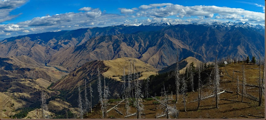
Hells Canyon is the deepest gorge in North America…it’s impressive!
On 27 September we wandered around Mount Howard…
The Wallowa Lake Tramway starts in Wallowa Lake Village. It climbs nearly 4,000 feet above Wallowa Lake. “The gondola is a Swiss-made tram, and was constructed in 1970 as the steepest vertical lift for a four passenger gondola in North America.”
We thoroughly enjoyed the ride up, leaning out of a small window to get pictures of the lake and the peaks of the Eagle Cap Wilderness. As we rose, we spotted snow in the trees. Finally, at 8,220 feet, we arrived at the top. Sure enough, everywhere was the remnants of the season’s first snowfall the week before.
The Summit Grill and Patio is adjacent to the lift terminal. But our plan was to hike the trails they have around the top of Mount Howard.
First, we started at the Royal Purple Overlook. We had an incredible view into the majestic Wilderness area. As we captured pictures, the area became crowded with other tram riders.
So we hiked a few hundred feet higher to the Summit Overlook. At the overlook, we found a nice square rock to sit on and soak in the scenery for a while. It was the first clear morning since we arrived a few days prior. The sun shone over our shoulders lighting up the view – perfect!
As we hiked the two mile route around top, we had to take care in 6-12 inches of snow as some of it had turned to ice and was slick.
From the “Snake River Country and view of the Seven Devils” overlook, we could see Hat Point where we had been the day before. As we approached the Valley Overlook, a woman informed us that a paraglider was getting ready to launch.
We rushed to the Valley Overlook. We were there with just a few minutes to spare. The paraglider quickly checked two windsocks, and ran down hill till his feet were airborne. We both snapped pictures till he disappeared behind a hill far below on his way down to Wallowa Lake.
We got comfortable and started snacking when a couple came up to the overlook loaded with paragliding packs. Oh good! Another show! As they prepared to launch, we started chatting with Jake and Shannon.
They own Bigfoot Balloons in Joseph. Taking a ride in a balloon over the Eagle Cap Wilderness would be amazing! They also enjoy other adrenaline sports such as skydiving and mountain biking.
We chatted about weather and what sort of atmosphere is ideal for them to fly the balloon and the paraglider. Jake said that the day’s weather was not as ideal as it could be.
However, both he and Shannon were able to stay aloft for quite a while. In fact Shannon seemed to float higher than us closer to Chief Joseph Mountain. We enjoyed meeting them and are pretty sure we saw them land a few days later on the beach while kayaking. We are always amazed to meet others that have made their passions their livelihood.
The ride down the tram was just as impressive! We agreed that the tram ride was worth the price.


Mount Howard adventure route / There was 6-12 inches of new snow in places


The tram climbs about 4,000 feet to the top of Mount Howard / See me on the stairs?

The Wallowas are incredible

The views from the top of Mount Howard are spectacular


Looking towards the highest peaks in the Wallowas / Looking east towards the Seven Devils in Idaho


We enjoyed watching the paragliders and learned a lot from Jake and Shannon


Jake and Shannon soaring above the mountains and lake
Later on the 28th, I kayaked…
The weather was perfect one evening, so I launched my kayak. It was a pleasure paddling two and a half miles on the glass-like lake. I fished for about an hour and got no bites. The highlight was watching the paragliders land gently on the beach. A couple of them slowly soared just 50 feet above me and said hello as they glided past…it was cool!


Kayak route on Wallowa Lake / I watched 5 or 6 paragliders gently land on the beach
On 29 September we had a hike and bike adventure…
“Wallowa Lake is a ribbon lake at an elevation of 4,372 ft. Impounded by high moraines, it was formed by a series of Pleistocene glaciers. These moraines begin well below the water's surface and climb to over 900 feet above the lake.”
“The most accepted hypothesis is that eight or nine glaciers formed the walls that now dam the lake. The last glacier advanced into the valley about 17,000 years ago and is known as the Wallowa Glacier.”
“Geologists often cite Wallowa Lake’s setting as one of the most perfect examples of glacier moraine in the world.”
We had noted locals often scrambling up the moraine from a pull out at the north end of the lake. So we scrambled up one morning, too, for a great view of the lake and Chief Joseph Mountain.
We were impressed to meet a PE teacher up there with his entire class. He advised us that we could walk the entire moraine to a gate on the road at the south end. That was just our sort of adventure!
The next morning we left our bikes hidden near the gate at the south end of the lake. We drove back to the north pull out and scrambled up the moraine.
The trail was evident across the ridge of the moraine. Though we did have to watch our footing since it was rocky as you would expect with glacial till. All around us glacial erratics poked out of the moraine at odd angles, all evidence of the frozen past.
Unfortunately, our pleasant amble was halted when we came to a 10 foot tall stock fence. It was built to keep deer and humans out. We agreed that it probably had been awhile since our teacher friend had gone this far.
Now we had the decision to hike back two and a half miles or to descend down to the road. We went with the later choice. Fortunately, there was loose dirt that we could dig our heels into. Arleen did more of a zig zag pattern and took her time. She clambered down 900 feet without trekking poles and without an issue. My girl is back!
We walked a half mile down the road to the bikes. It was a quick three mile ride back on the bikes. We did stop at the boat launch to admire the brilliant maple leaves.
Our adventure did not go exactly as planned. However, it is one that will forever be memorable.


Hike and bike route / Funky legs and socks after a tough descent to the lake


Just posing above beautiful Wallowa Lake. Chief Joseph Peak, 9,617 feet, towers over 5,000 feet above the lake.

A fantastic spot for a break

Looking up the glacially carved valley. The state park campground is tucked under the trees on the right.

Wrapping up a tough adventure
Alpenfest…
“Oregon's Alpenfest is a long-running Swiss-Bavarian cultural festival held on the last weekend of September in Wallowa County, Oregon, known widely as Oregon's Little Switzerland. Oregon's Alpenfest is the only Swiss-Bavarian festival in the western U.S. and salutes the other nations that stretch through the Alps – Austria, Slovenia, Liechtenstein, France, Italy and Monaco.”
We walked into town to check out the festivities. We poked our heads in the door of the historic Edelweiss Inn to admire the Tirolean Dancers.
The Alpine Fair included wooden trekking poles, quilts, and wood works. Naturally, the food booths offered bratwurst, apfel strudel, and of course Alpen beer! Everyone seemed to really be enjoying themselves!

The historic Edelweiss Inn


Alpenfest fun
A physical week…
During our last seven days at Wallowa, the weather was beautiful! We were outside most days hiking, biking, kayaking or just sauntering around the State Park.
During that week our Fitbits reflected 150,000 steps. That is 8.5 miles per day!
The week marked exactly 2 months since Arleen’s back surgery. She is thrilled with her progress. And I am very happy to have my girl back with me enjoying the corners of this incredible country!

We hiked, biked, and kayaked roughly 60 miles in a week. And just two months after Arleen’s back surgery!
Next…
We detoured to La Grande OR for truck maintenance and then hope to make it to the John Day River near Rufus OR. Then we’ll spend the rest of the fall on the fantastic Oregon Coast: South Beach near Newport, Winchester Bay, Yachats, Nehalem, and Fort Stevens.
Parting shots…


Arleen always makes friends with horses / Osprey flying towards the snow covered mountains


The Wallowa River above the campground / Kokanee salmon were spawning in the river

There were lots of good wall murals in Joseph. This one is especially cute.
(182,200)
Great review of Joseph and Wallowa Lake. Fond memories revisited. And all those places on the Up Next list. Wish we could join you.
ReplyDeleteYou guys did this spectacular part of Oregon up right! Looks like your weather was perfect too. Beautiful shots!
ReplyDelete