


Two weeks near Whitefish MT...
Why we came...
To
explore Glacier and for a reunion with old military friends!
The campground...
Mountain View RV Park was only five
miles from Whitefish. It was a
comfortable and clean park with 46 pull-thru sites. They were level and we had full hookups. The park has a few back-in sites but they are
short and hookups are far away. There
was decent space between each site. It
is next to highway so traffic noise was prevalent during the day and tapered
off each night.
There
are only a few trees so it was not a problem getting satellite. There was an ok Verizon signal and the wi-fi was
strong during the first part of our stay and sporadic towards the end (a data
hog probably moved in). The
restrooms/showers were kept clean and the laundry had 2 sets of washers and dryers.
“We
are only 22 miles to the gateway of Glacier National Park, 2 miles to the West
is the Whitefish River, 3 miles to the East is Flathead River and 5 miles North
West is Whitefish Lake. Flathead Lake is 30 miles south and is the largest
natural fresh water lake west of the Mississippi with over 200 square miles
of water and 185 miles of shoreline. Mountain View RV Park boasts
beautiful views of Big Mountain, Teakettle Mountains, Columbia Mountains along
with gorgeous sunsets to boot!”
 |
| We had full hook-ups and decent space at Mountain View RV Park |

Nearby towns...
ColumbiaFalls, population ~5,000 and elevation 3,087 feet, has a decent selection of restaurants, two grocery stores, and some services. It’s a busy little town surrounded by an outdoors paradise.
Whitefish, population ~7,000 and elevation 3,028 feet, is 10 miles west and has more of a resort town feel. It has more restaurants, stores, and services. It sits at the south end of beautiful Whitefish Lake and there is a decent sized ski resort nearby. We could easily live there!
Kalispell, population ~22,000 and elevation 2,956 feet, is 17 miles southwest and is the main shopping and service center in the area. It feels much bigger and busier than its 22,000 people population. In fact, Wikipedia says there are nearly 100,000 people living in the Kalispell area, which includes Columbia Falls and Whitefish.
Adventures...
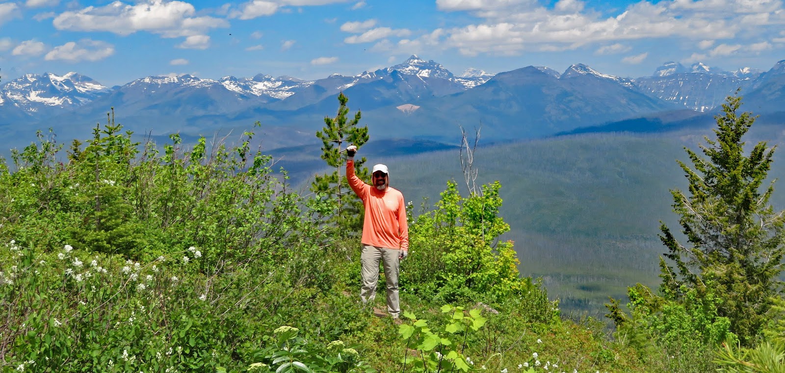
On 1 June we hiked to the top of Big Mountain…
Arleen was antsy to do a hike with
some vertical so we drove up Big Mountain road to Whitefish Mountain Resort. The original Big Mountain Resort
was a community effort and opened its ski lifts in 1947. It was renamed
Whitefish in 2007.
“Today Whitefish offers 3,000 acres
of glades, groomers, bowls, and steeps, covered in more than 300-inches of
Rocky Mountain powder snow. Whitefish is actually not a “ski town,” it’s a town
of skiers.”
There are a number of homes and
condominiums at the base of the mountain. The ski resort stays busy during the summer with mountain bikers, alpine slide,
zip line, spider monkey mountain, aerial adventure park, and scenic lift rides
to the summit where there is a nature center but that all does not kick off
till after June 15th.
It was the 1st of June
and a Saturday. So we were thankful it
was still quiet and that the lift was running.
Arleen is always looking for a slide
or a zip line down when we do a steep uphill hike. Whitefish Mountain Resort has the perfect hike for her. We would hike 4 miles and climb
over two thousand feet on the “Danny On” Trail and then ride a ski lift down!
“The Danny On Trail was dedicated as
a memorial to Danny On, a Forest Service silviculturist (forest ecologist) and
renowned nature photographer, conservationist and avid skier on The Big
Mountain. Danny died at the age of 55 in a skiing accident on The Big
Mountain.”
We weren’t sure we could get to the
top because of snow. According to the
signs posted, there were snow fields about two miles up the trail. We headed up to find out for ourselves.
We meandered up the tree-lined switchbacks
and paused when the trail crossed the ski runs that were clear of trees to take
in views of the valley below. It was
filled with smoke from a large wildfire in Alberta but as we climbed and the
afternoon waned, the visibility improved.
As the trail took a left turn from
the south side to the east side of the mountain, we encountered snow fields
near the base of Chair 5. We took a
break to ponder our options. How wet did
we want to get? Did we really want to
post-hole another mile and a half up the mountain? We knew a hot lunch was waiting
for us at the Summit House so we decided to press on.
Suddenly, a golden doodle scampered
down to us from the Moe-Mentum ski run.
Like an angel, his partner, a tiny, gray haired, elder lady made her way
down through the snow. She was a local taking
advantage of the outdoor paradise in her backyard. She hikes Big Mountain a few
times a week during the summer and skis all winter.
After, our mountain angel had
inspired us, we headed up the ski run and the snow fields. Thankfully, the snow was still firm and we
did not post-hole at all except on the edges.
It was steeper than the trail, so we paused frequently. It was clear that our month in Roundup had
set back our fitness.
We crested the final steep pitch and
while our pulses slowed we admired the vast views of Flathead Valley, the jagged
peaks of Glacier National Park, the Canadian Rockies, and the Bob Marshall,
Great Bear, Scapegoat, and Cabinet wilderness areas. Incredible!
We noted the temperature on the
summit was 54o and it was breezy.
It felt chilly as soon as we stopped moving.
We moved out of the cool air into
the warm Summit House and ordered tomato soup and grilled cheese
sandwiches. We ate our lunch next to a
window where we enjoyed the expansive views.
Finally, we took a chilly 10 minute
ride down the Scenic Lift to finish Arleen’s ideal hike.
 |
| We hiked to the top of Big Mountain and then rode the lift down |
 |
| Glacier lilies are one of our favorites |
 |
| First patch of snow was about half way up |
 |
| Approaching the top |
 |
| We made it! |
Glacier National Park,
established in May of 1910, is in the northwest corner of Montana sharing the
Canadian border with its international peace park, Canada’s Waterton Lakes
National Park.
“The park encompasses over 1 million
acres and includes parts of two mountain ranges, over 130 named lakes, more
than 1,000 different species of plants, and hundreds of species of animals.
This vast pristine ecosystem is the centerpiece of what has been referred to as
the "Crown of the Continent Ecosystem", a region of protected land
encompassing 16,000 square miles”.
“The current glaciers in the park
are estimated to be at least 7,000 years old and peaked in size in the
mid-1800s, during the Little Ice Age.” Today there are roughly 30 glaciers
clinging to remote mountain sides.
Glacier National Park has several
main areas. We’d explore seven of those
areas over six weeks. We’d visit the Lake
McDonald and the Walton area on the west side area in our first two weeks and the
Two Medicine, St. Mary’s, Logan Pass, and the Many Glacier area the next two,
and the Canadian Waterton NP in our final two weeks.
Our
first day in Glacier, we rode our bikes part way up the Going to the Sun Highway. The park slowly opens the road to hikers and
bikers as they clear it of snow. Most years the road opens to vehicles by late
June.
We
parked at Avalanche Lake campground which was where the highway was gated. In addition, the campground was still closed
to camping to make room for parking for all the hikers and cyclists headed up
the epic road. It was only half full at
1000L but filled up by the time we got back – and it was a Monday!
We
eagerly hopped on our bikes and took our time to admire the incredible scenery. The first few miles were relatively flat and
then it pitched consistently up for the next six miles. We stopped to ham for a few pictures and felt
like we had our own National Park.
The
final mile pitched up to a 6% grade. The
views were even more punctuated by waterfalls as we climbed high above the
valley. We slowly rode through a wet
tunnel and appreciated the cold spray as we tried to catch our breath and cool
off.
The
“Road Closed’ sign was posted just above the main switchback: “The Loop”. About 10 fellow riders were hanging out, chatting
about the incredible adventure and other things. The ride down was SO much fun
until we had to fight a stiff headwind – just as forecast. Otherwise the weather was nearly perfect for
an epic day.
 |
| Bike route on Going-to-the-Sun Road in Glacier NP |
 |
| We love having our own national park! |


 |
| We slowly rode by a few pretty waterfalls |
 |
| We made it! |
On 4 Jun we did a short hike on Columbia Mountain Trail...
Columbia
Mountain
is a 7,200 foot peak between Columbia Falls and Hungry Horse. There is a Mother Nature’s stair climber of a
hike with switchbacks climbing 5,000 feet over 6 miles. It was a gorgeous day without any smoke – the
type of day you cannot waste!
We
hiked up just over a mile for a good view and a good aerobic workout. We climbed 800 feet up just a few of the many
switchbacks. Our legs felt like stumps
after the bike ride the previous day. We wanted to save them for next day: a tough
hike to the Apgar Lookout.
 |
| Hike route a little ways up the Columbia Mountain trail |
 |
| Vibrant penstemon flowers |
 |
| This was our best view. Looking down towards the Flathead River and the peaks of Glacier NP. See the train? |
Glacier
National Park has nine lookout towers (there were 17 at one time). Of those four are still utilized today. Apgar Lookout Tower is probably the
most easily accessed.
“The original lookout was constructed
in 1929, but burned down only two weeks after its completion. It was
immediately replaced with the current two-story wood frame structure on the
premises today. Although no longer in use, the fire tower is considered an
historical structure, and is listed on the National Register of Historic
Places.”
“The village, mountain, fire tower
and trail are all named after Milo Apgar, who was among the first permanent
families to settle on Lake McDonald in the early 1890s. Mr. Apgar built homes
and cabins for tourists in this area, which would later become Apgar Village.”
The trailhead is just over 3 miles
from the visitor center though two miles of it is down a narrow dirt road. And
the road crossed a cool single lane wooden bridge over the tropical colored
McDonald Creek.
The trail starts out flat and in the
woods. Then it pitches up and makes 3
long sweeping switchbacks before we got to the tower after almost 3.75
miles. We climbed 2,000 feet.
As we climbed we had sweeping views
back to the Bob Marshall Wilderness.
From the top we were able to take in views of the southern Glacier Peaks
and Lake McDonald.
There were a few dozen folks when we
arrived. Three of them were folks that
we had chatted with on the way up. We
had offered to take pictures of each other a few different times.
 |
| Hike route to the Apgar Lookout in Glacier NP |
 |
| The top of that hill is our goal |
 |
| We love the bear grass |
 |
| Great view looking up the valley |
 |
| Looking southwest towards West Glacier and Hungry Horse |
 |
| Getting closer. The Flathead River and West Glacier are far below. |
 |
| Getting wind-blown near the top with the jagged peaks of Glacier behind |
 |
| The view from the Apgar Lookout towards the northeast |
 |
| Success! |
Then our friends arrived!
Last
year military friends from our Alaska days in the late ‘90s came up with the
brilliant plan for a reunion. We were
all weather forecasters stationed together at Elmendorf Air Force Base. A few
worked at the base weather station and a few worked at the Alaska Forecast
Unit.
We
were honored that they selected West Glacier based on our schedule. Whitefish would make a good base camp with
plenty of places to stay, a good selection of restaurants, and a variety of
things to do.
Including
us, FIFTEEN came: Troy and Dawn (left Saturday), John and Debra (left Sunday),
Joe and Trish (both forecasters), Sven and Cheryl, Steve and Raymona, Bill and
Tami, and Lance who arrived late Saturday.
The main group left Monday morning but Lance stayed till Wednesday so
the three of us could do a few more challenging adventures.
All
of us are either retired or separated from the Air Force now. We figured there was about 200 years of total
military experience in our group! A few of them still work in the weather career
but others have branched out. Of the
nine former weather forecasters we had a lawyer, an RN, a financial planner, an
IT technician, an antique auto restoration expert. Our group came from all over: Alaska, North
Dakota, Michigan, Nebraska, Louisiana, and Arizona.
With
the exception of Lance they all arrived Thursday afternoon. Arleen and I greeted them at the Best Western
Rocky Mountain Lodge
as they arrived. Except for a few folks
we visited in Alaska last year, we hadn’t seen most of them in twenty years.
After
they were all checked in, we went to the Montana Tap
House
for pizza and refreshments. As Bill said, "It's like we just put down our
beer yesterday, and picked it right back up today!"
 |
| Military friends from our Alaska days came from all over the country for a reunion |
On 7 Jun we rafted the Flathead River...
We
are thankful to Sven for setting up the whitewater rafting adventure with Wild River Adventures. “Combine
our Half Day Whitewater Adventure (9 river miles) with a tasty riverside barbecue dinner. Evening light makes
our mountains glow and provides the perfect backdrop for a hot, delicious meal!”
We met at their office in West Glacier.
First, we squeezed into wetsuits which was a very entertaining process
(painful?) for some. There were several
in our group that had never been rafting and they were understandably nervous
and excited.
We took a bus up Highway 2 to the put-in spot on the Middle Fork of the
Flathead River. The next eight river
miles run through a fun canyon with several Class 2 and Class 3 rapids.
Since there were 14 of us we were put on 2 different rafts. Sven and I volunteered to take the lead in
our raft. We each had a paddle and our
guide gave us instructions on how to get safely through the big waves.
We
were glad for the wet suits since the outside air temperature was just 50o
and the water was just 37o. The
spectacular scenery in the canyon soon made us forget how chilly we were.
At
the beginning of the float a shower moved over us and we were assaulted with
huge raindrops and hail. It confirmed
the weather person’s curse of guaranteed bad weather for outdoors
activities! Soon after, the sun poked
through and we had great weather for the majority of the float.
As
we moved down the river, the guide would shout, “right paddle” or “left paddle”
and we would push in unison to get through the rapids. In some of the thrilling big ones we pitched
up into giant holes and were splashed as big waves collapsed on us! We all yelled and laughed in unison!
But
we all stayed in the raft till we got to the slow water towards the end. Then,
Troy purposely jumped in the water to see how cold it was!
At
the pull-out spot, we dragged the heavy rafts out. There were already tables set up on the
river. Our guides got busy grilling steak,
chicken, salmon and potatoes while we slipped into the woods to wriggle out of
the wet suits and into our comfortable clothes that the bus driver had brought.
It
was a fabulous meal with a fantastic view.
Dinner featured fresh salads, baked
potatoes, and a pound cake with berries dessert. Then the rain and hail showers
moved back in as we quickly tore down camp.
Back
at Wild River Adventures, we went next door to the Crown of the Continent
Discovery Center for hot chocolate to warm up a bit.
The dam backs up the South Fork of
the Flathead River between the Flathead Range and the Swan Range. The large
lake is 34 miles long and the drive around it is 115 narrow dusty miles!
The scenic background made for a
great group shot!
 |
| Rafting route down the Middle Fork of the Flathead River |
 |
| Headed to the river |
 |
| The gang at the river. Nice boobs Troy! |
 |
| Getting instructions before we launch |
 |
| The other team getting their instructions |
 |
| Just shoved off! |
 |
| Good times on a pretty river |
 |
| It’s SO fun! |

 |
| We stopped to see the Hungry Horse Dam after the rafting adventure |
On 8 Jun we did a couple of short hikes in Glacier NP...
Unfortunately, the next day it
rained for most of the day. Sadly Troy
and Dawn had to leave that morning. The
remaining group had time to shop and check out Whitefish.
The rain tapered off in the early
afternoon and we made an impromptu plan to all meet in the Park. John and Debra had to leave the next day and
they wanted to see Glacier. We wanted to
get Debra’s new boots dirty so Arleen and I suggested a couple of short hikes.
First, we hiked the Rocky Point Trail
near the Fish Creek Campground on Lake McDonald. The nearly mile long trail was perfect with a
few rolling parts, a creek crossing, and lots of wild flowers. Our destination, the shore of pretty Lake
McDonald with mountains all around, was perfect for another group photo op.
Trail of the Cedars
is an extremely popular hike and normally crowded. However, we arrived in the late afternoon and
thoroughly enjoyed a mile long saunter on the boardwalk through the giant
western hemlocks and red cedars.
We finished the day in Whitefish at the Piggyback BBQ. We shared delicious giant trays of BBQ Brisket, Sausage, Pulled Pork and chicken. We also shared more stories and conversation. The waitress generously let us stay past her normal closing time as we made plans for the big hike the next day.
 |
| Hike route to Rocky Point in Glacier NP |
 |
| That's a sturdy bridge! |
 |
| Being goofy at Rocky Point in Glacier NP |
 |
| Hike route on the Trail of the Cedars |
 |
| Crossing Avalanche Creek |
 |
| Avalanche Creek cuts through a narrow gorge. It's very pretty. |
On 9 Jun we hiked to Avalanche Lake in Glacier NP...
We all met for breakfast the next
day at the Best Western to send off John and Debra. They planned a day trip through the National Bison Range
on their way to the Spokane Airport. We also welcomed Lance who had flown in late
the night before.
Our planning went awry. The day turned
into our now famous “Sorry Folks, Park’s Closed, Moose out Front should have
Told You” adventure.
After three days of clouds and rain,
the forecast was for partly cloudy to mostly cloudy skies. So our little group (which included 8 weather
forecasters) excitedly headed to Glacier National Park for a hike to Avalanche Lake. Since the weekends had been very crowded and the
Avalanche parking area filled before noon, the plan was to park at the Apgar
Visitor Center to take the shuttle.
By the time we ate breakfast, wished
John and Debra happy travels, stopped at Subway for sandwiches and drove into
the park, it was noon. The shuttle got
us to trailhead about a half hour later.
Finally, at 12:30L we started hiking
up the trail! The views were immediately
impressive after walking through the Trail of Cedars. Avalanche Creek in peak runoff is a pretty
aqua colored river ripping through a twisting and turning granite chasm… So
pretty!
Trish, Steve, Arleen, and I set the
pace. After the trail follows the creek
for a short distance it cut back into the cool dark woods. As we walked, raindrops assaulted us. We angrily yelled at the sky, “No, today was
supposed to be nice!” The sky responded
with a few flakes of snow and pellets of hail.
Shortly after that, thunder boomed through the canyon… The weather
person’s curse was at work again! It was
going to be one of those days. We
accepted our fate and pushed ahead.
We popped out of the trees for a
gorgeous view of a pretty aqua lake back-dropped by mountains and sheer cliffs
dusted with fresh snow. We walked the
edge and settled on some big glacial rocks a few hundred yards down the
shore. Thankfully, the rain had stopped
and the clouds even parted a time or two allowing us to view a patch of blue
sky.
After a while we saw the rest of the
gang emerge from the woods. We waved and
Joe was the first to duck back into the woods and head our way on the upper
trail. Then the rest of the gang followed
a few minutes later. They joined us on
the rocks soon after that. But no Joe or
Lance!
After a while, Trish got more concerned
about Joe. After all, he had her sandwich!
Arleen and Bill decided to go search
for them. Arleen walked east along the shore while Bill scrambled up to the trail
to try to flush them out. Bill asked a
day hiker if they had seen Bob Segar.
Yes, Bob’s at the east end of the lake!
Bill fetched them and soon our group was together again.
We spent a few hours relaxing at the
lake. Then I did the math and realized
we were going to miss our dinner reservation.
So Arleen and I set out to catch the shuttle to Apgar, where we’d have a
cell phone signal, and change reservation to a later time. When we got to the shuttle, we discovered we
were on the 5:00pm shuttle – the last of the day… “Sorry Folks, Park’s Closed,
Moose out Front should have Told You”! We
asked the shuttle driver if there was any way she could help us. We still had 9
people on the trail. She replied that
there was nothing she could do and politely told us that we should have read
the signs… DUH!
So we got back to the Visitor Center
and came up with a plan to fit all 9 folks in our truck. We emptied everything from the front and then
took out a bike and bins filled with stuff from the back of the truck. We piled everything around a bench where Arleen
would stay to make phone calls and to guard our stuff. I hurried back to Avalanche to find our
stranded team.
In the meantime, the merry band of
hikers had figured out they had missed the last shuttle. Bill and Sven caught a ride back to McDonald
Lodge and were walking the road when I spotted them.
When we arrived at the trailhead,
Trish and Tami were pleading with a Ranger for help. After scolding them for not reading the sign
(DUH!), he agreed to give a couple of people a ride back to the Visitor
Center. Tami eagerly volunteered because
she didn’t want to ride on anyone’s lap!
I didn’t want the Ranger to give me a ticket for unseatbelted passengers.
To delay loading until the Ranger left, I asked someone to use the
restroom. Then we loaded up with 5
people in the front and 2 in the back… nobody was even lapped up! The whole way back we laughed at the silly
situation.
Arleen had made new reservations for
7:30 pm at the Columbia Falls Meadow Lake golf course. Amazingly we arrived 5 minutes early! They sat us outside in their garden among the
flowers and the weather even cooperated. Our servers treated us great and even
brought Lance a birthday cheesecake! For
the second time that week, we closed a restaurant.
 |
| Hike route to Avalanche Lake |
 |
| Me and Lance. So glad he joined us! |
 |
| Chatting about something on the trail |
 |
| Arleen and Trish walking the shore of Avalanche Lake |
 |
| Avalanche Lake is beautiful |
 |
| Lance and I getting some air |
 |
| The gang at Avalanche Lake |
On 10 Jun we hiked to the top of Big Mountain with Lance...
We started the day at the Best
Western for breakfast with our friends.
Steve, Raymona, Bill and Tami were going to drive through the northwest
corner of Montana and check out the Libby Dam and the Kootenai Falls on their
way to the Spokane Airport. Sven,
Cheryl, Joe and Trish were going to visit Yellowstone National Park, meet up in
Jackson, Wyoming for a few days and hike in Teton National Park.
That left Lance, Arleen and I. Lance is in better shape than I am so we were
eager to take him on a few challenging hikes.
We started with Whitefish Mountain Resort. Lance is a skier
too, so we knew he would appreciate it.
The only issue was that it was a
Monday and the lift wasn’t operating so we would have to hike up and down. Arleen was a little disappointed.
We hiked swiftly up The Danny On
Trail switchbacks. Again, we paused when
the trail crossed the ski runs to take in views of the valley below. Today, there wasn’t any smoke and we had a clear
view of the scenic area.
We took a break on the bridge in the
Chair 5 area. Then we headed up the Moe-Mentum
ski run. We were amazed that there was
only a 1/3 of the snow that there had been the week before. Still it was a good workout to move up the
ski run.
Finally, at the summit, we looked
down at Flathead Valley and out at Glacier National Park, the Canadian Rockies,
and the Bob Marshall, Great Bear, Scapegoat, and Cabinet wilderness areas. Again,
the visibility was SO much better than our previous visit!
We took shelter from the biting wind
on the porch of the closed Summit House.
We still had a great view during our break.
Finally, we made our way back down
the Russ’s Street ski run. It was longer
but not as steep of a gradient for our tired knees. Since, we stayed more on the north side of
the mountain, there were quite a few snowfields, nonetheless we had a good time
sliding down in our boots.
 |
| Hike route up Big Mountain with Lance |
 |
| Approaching our goal |
 |
| About a third of the way up. The town of Whitefish is above Lance. |
 |
| Lance making it to the top |
 | |
| The victory pose! |
 |
| Headed back down through the snow |
On 12 June we hike to the Scalplock Lookout...
Lance was scheduled to leave on an
evening flight. First, we had plans to
do our toughest hike of the summer.
We drove to the seldom visited Walton
area. “The Izaak Walton Inn is a historic inn in Essex, Montana. It was
originally built by the Great Northern Railway in 1939 for lodging railway
workers. In addition to railway lodging, the hotel was also originally
envisioned as a potential official southern gateway to Glacier National Park,
but that plan never materialized.”
The
Inn is still there on the right side of the highway. On the left is a ranger station, a picnic
area and the Scalplock
Lookout
Trailhead. We backed the truck into a
picnic area.
The
trail starts out flat with views of the Middle Fork
of the Flathead River. It
crosses back and forth with the horse trail but is easy to follow. Where the horses cross the creek, we followed
the trail to a cool swinging bridge over the roaring Ole Creek.
After
a half mile it pitched up and the switchbacks through the woods started. It was sloped just enough to get our heart
rate up but not so bad that we had to stop frequently.
Occasionally,
we’d have a peak down at the river and across to the Great Bear Wilderness and
the Flathead Mountain Range. It helped
us hurry up the trail because each view was better.
Finally,
after almost four miles of switchbacks, we broke out above the tree line for a
fantastic view beyond the Great Bear to the Bob Marshall Wilderness. We
followed the trail across the rocky ridge.
Avalanche Lilies were popping
everywhere.
We
had to cross a few snowfields and after starting to post-hole, it was just
easier to cut across the spine of the rocky ridge. We didn’t get a look at the tower till we
were just below it.
The
Scalplock Lookout was built in
1931. It is a 2-story frame cab and is
still staffed in the summer. “It was rehabilitated in 1999 and is listed on the
National Historic Lookout Register.”
We climbed the stairs and were treated by a 360o
view of mountain ranges all around us. We
could see some of the highest peaks and craggiest peaks in Glacier NP to our
north. It was stunning!
We took a break on the catwalk and tried to take in
the view. We tried to get decent picture
but were hampered by the trees that have grown up around the perimeter. Still, the image is forever burned in our
mind’s eye.
We left sooner than we wanted to. Lance had a plane to catch and we had 5 miles
of downhill hiking ahead of us followed by an hour long drive.
The
Scalplock Lookout is in a quiet area of the Park, and we had it nearly to
ourselves. We only met one couple coming
down the trail and another couple headed up while we headed down.
We
took Lance to the airport; bid him farewell and we all promised it would not be
another 20 years before getting together for the next adventure.
 |
| Hike route to the Scalplock Lookout |
 |
| This was a fun bridge to cross. It swayed a lot! |

 |
| Finally popped out of the trees and were treated to an incredible view |
 |
| Near the bottom of the final ridge and looking south |
 |
| The lookout tower is at the top of the hill in the upper left |
 |
| We loved walking along this ridge and were blown away by 280 degree views. |
 |
| Just below the top and looking down to the Flathead River |
 |
| Lance at the Scalplock Lookout |
 |
| The victory pose! |
 |
| The views from the Scalplock Lookout are incredible |
Next...
We are in St Mary MT exploring the east side of Glacier National Park. Next we head to Pincher Creek AB to play in Waterton Lakes National Park. After that we hope to check out Banff, Lake Louise, and Jasper.
Parting shots...
 |
| A rickety bridge across McDonald Creek. The Flathead River is on the right. |
(238,200)