


Why we came…
It’s an interesting area with incredible geography and good fishing!
The campground…
Sun Lakes Parks Resort is a privately owned campground in Sun Lakes-Dry Falls State Park. The RV sites are good sized. We had a premium site with a good view. Some are oriented where you park back to back and share utilities. Things are a little outdated but it is well maintained and they are making improvements. The bathrooms were kept very clean during our stay. Satellite would be tough from some sites due to mature cottonwood trees. Cell phone and wi-fi were both weak and unreliable.
There is a lot to do and the area is well suited to families and groups. There are large lawn areas, a pool, a lake, boat rental, miniature golf, and a 9-hole golf course. There were several choices for long walks. In addition, you can hike to longer trails in the large state park.
 |
| Sun Lakes Park Resort was nearly empty the first half of our stay. That’s Park Lake. |
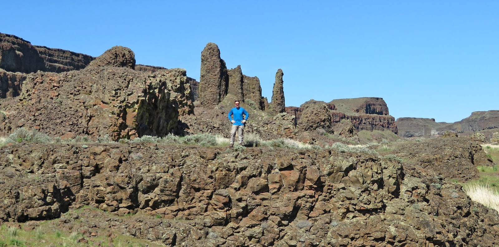
 |
| Those cliffs are over a thousand feet high |

 |
| The arrowleaf balsom root was blooming all over |
 |
| These deer moved back & forth most days |
Coulee City, population 562 and elevation 1,588ft, is a seven mile drive to the northeast. It has a small but well-stocked grocery store, a gas station, and a few stores. Everybody we talked to was very friendly.

The are other little towns to the south, but Ephrata, population 7,664 and elevation 1,276ft, 24 miles to the south has the most stores and services. We didn’t check it out.
Adventures...
The Geology...
The
majority of the unique eastern Washington landscape can be traced back to
forces that began 17 million years ago.
At that time two significant basalt lava flows filled the area with flows
as much as 2 miles thick. The upper
portion of the lava cooled quickly and hardened into the massive cliffs known
as “Entablature”. Basalt that oozed and
cooled slower hardened into softer “Colonnades”.
This
went on for 11 million years! Once, the
flows were over, earth’s internal forces lifted and warped the entire area.
About
a million years ago the most recent Ice Age began. Ice sheets a mile thick moved south. Glaciers covered northern areas of
Washington, Idaho and Montana. “At its
leading edge, the ice dammed rivers and created lakes. At times, the Columbia River was forced to
flow through what is now the Grand Coulee.”
Glacial Lake Missoula formed behind ice dams about
12,000 years ago and covered areas of eastern Washington and all the way east to
present day Missoula, Montana. The lake
was 2,000 feet deep at times and the pressure of the deepening water slowly
weakened the ice.
“Catastrophic
floods raced across the southward-dipping plateau a number of times, etching
the coulees or ravines that characterize this region, now known as the
Channeled Scabland.” The flow was “up to ten
times the combined flow of all the rivers of the world”!
Two
major waterfalls, Dry Falls and one near Soap Lake, formed in areas where there
were more Colonnades that fell to the force of the water. Dry Falls was 350 feet high and 3.5 miles
long!
These flooding events
happened again and again for a couple of thousand years! |
| When the ice dams broke, the waterfall here was 3 and a half miles wide and more than 400 feet high making it the world’s largest |
 |
| Arleen on the observation deck |
 | |||||||
| Dry Falls Lake and artist’s rendition of the huge waterfall that created it |
The
Visitor Center is perched on the northwest ledge near the falls. We chatted with Ranger David McWalter who was
testing the handicapped lift as we walked into the Center. When we got to the top of the stairs, he
asked us if we wanted to see something cool?
We were hooked: “Yes, we would like to see something cool!”
He
took us around to show us the “world’s largest High Definition T.V. (12’x30’)”.
T.V. stands for Terrain Vision. David eagerly
explained that through the T.V. you learn about incredible geology and witness
weather and wildlife. Another
interesting tidbit he shared was how the rain pulls the nutrients from all the
lichens on the basalt. It acts as a
fertilizer for plants growing in an otherwise inhospitable environment. As we looked around at the scree slopes we
could see plants including blooming choke cherry bushes.
Afterwards,
we watched a Nick on the Rocks explanation and animation of the massive floods. It brought it all to life!
Nick on the Rocks: Dry Falls
 |
| We really enjoyed talking to Dave and learned a lot |
 |
| Lots of interesting info on the signs. Click the pic to read it. |
 |
| Lots of interesting info on the signs. Click the pic to read it. |
Dry Falls Lake...
A
few spring fed lakes have been left behind where the water once raced through. In Dry Falls Lake State Park, there are a
number of smaller lakes and the larger Park Lake. 88 acre Dry
Falls Lake has good fishing for Rainbow Trout.
We
launched our kayaks early on two different mornings to beat the area’s
notoriously strong winds. We fished the
deep drop-offs next to grass growing along the ledge; perfect trout
habitat. Each morning we joined a few canoes,
drift boats, and various float tubes. Fishing
was tough. We saw just a few trout
caught. These are smart trout and
remained elusive to us.
 |
| Kayak route around Dry Falls Lake |
 |
| This is just part of what was the world’s largest waterfall. See Arleen? |
 |
| It’s incredible to imagine huge amounts of water plunging over those cliffs |
 |
| See me? |
 |
| That’s Umatilla Rock towering above me. We climbed through that gap. |
 |
| My turtle friend |
 |
| Red winged blackbirds were very active and very vocal |
 |
| Some geese flew overhead and others might have been nesting. Most were quite noisy! |
 |
| There were lots of scaups on the lake |
 |
| Turkey vultures soared overhead. Crows put on aerial displays and turkeys gobbled too |
Lake Lenore...
Lake
Lenore is 10 miles south of Dry Falls Lake State Park. At 1,406 acres Lake
Lenore is much larger than Dry Falls Lake.
“Lenore is most famous for its very alkaline waters that only Lahontan
Cutthroat Trout can survive in. This lake is an anglers best chance to
catch a trout pushing or slightly exceeding 30 inches.”
Spring
can be the best time to catch them as they cruise close to the shore looking
for a place to spawn. The inlet at the
north end of the lake is often a hot spot.
I prefer to fish alone so I tried a secluded spot about a mile away from
the crowd.
The
water was off colored with quite a bit of vegetation debris. I was determined to hook one of these special
cutthroat trout and fished hard on four different evenings. I got excited a couple of times when I
spotted a cutthroat cruising by but my offerings were ignored.
I
might have made friends with a mother goose. The first time I approached my
fishing spot, she honked noisily from a nearby rocky point and flew away. As she circled, honking the whole time, I got
close enough to the rocky point to see her nest. There were no eggs. The next day I gave her a wide berth. She watched me but stayed on her nest. I’m sure she laid eggs and I’m relieved I
didn’t disturb her.
I’ve
struggled to catch these Washington trout.
Maybe I need to leave the state and go find some dumb trout!
 |
| Lake Lenore is big. This is the view from my fishing spot as the sun dropped below the thousand foot high cliffs. |
 |
| Fishing a weedy point |
 |
| I liked this rocky spot better. |
 |
| See the goose nest? No eggs yet, but I’m sure she laid them the next day. I gave her plenty of space. |
Umatilla Rock...
The Umatilla Rock Trail makes a nice
two and a half mile loop around the prominent geologic feature. Umatilla Rock is a “narrow rock blade” rising
over 300 feet above the chasm floor.
Somehow it survived the multiple floods.
Most
of the trail was fairly level but fluctuated between being rocky and sandy. As we hiked along the south side, we posed on the
basalt remnants of the “Colonnades”
that were washed to this location during the powerful floods.
After
roughly a mile we came to a “Y” in the trail.
To the right was the main trail going around the end of the lofty rock
blade to Dry Falls Lake. To the left, was a
steep trail going up and through a pass between higher cliffs. We went left.
From
the pass, we had a great view down to Dry Lake and up to the visitor’s
center. It was the perfect place for a
break! We also saw that the scree trail
down would be challenging.
We
took our time sliding down. Arleen
literally scooted along on her butt over the steepest sections. Her risk management needle is more easily
pegged these days!
 |
| Hike route around Umatilla Rock |
 |
| Walking the trail through rough landscape |


 |
| The view from the pass through Umatilla Rock |
 |
| Imagine tons of water rushing through here |
Lenore Caves...
We
first visited Lake
Lenore Caves in May of 2009 when we were stationed at Joint Base
Lewis/McChord WA. “The caves themselves are shallow, created during the Great
Missoula flood as water pulled chunks of basalt from the walls of the coulee.
After the waters retreated and the caves had been created, early native people
used these areas as shelters.”
 |
| Hike route to Lenore Caves and along Alkali Lake |
 |
| The trail is on the left and the first caves are on the right |
 |
| We’re always surprised to see stairs on trails but we appreciate them |
 |
| Approaching the first cave |
 |
| The colorful lichen was amazing |
 |
| More colorful lichen high above Lake Lenore |
 |
| The next set of caves. Lenore Lake is on the right. |
 |
| These are the largest caves. See me? |
 |
| We didn’t see any bats so we turned into them! |
 |
| Shooting star flowers near Alkali Lake |
Next...
We spent time in Spokane WA, Curlew Lake WA, and Kelowna BC. Then we made an unplanned detour to Roundup MT to help Arleen's mom.
Parting shots...
 |
| A bright full moon rising over the cliffs |
 |
| Arrowleaf balsamroot peaked during our stay |
(235,300)
Great report on one of the best of Washington State's State Parks! Happy Camping!!!
ReplyDelete