


(Written by Arleen)
Why we came...
To explore Banff, Kootenay, and Yoho Canadian National Parks!
The campground...
There are a ton of camping options in Banff National Park. The park has a total of 2,356 camping sites.
I reserved our site on the day that they opened up the reservation system for 2019. However, it is hard to get a choice site when you are staying for a longer period of time when a large city like Calgary, population of 1,600,000, is only 80 miles away. All the weekend slots fill fast! We felt lucky to get a site for 2 weeks at all but it was in Village II.
Tunnel Mountain Village is the largest campground and is located within three miles of the Town of Banff. It is HUGE! There were 827 sites open for 2019. They were divided between Trailer Court and Village II. We were in Village II that has 188 sites, and it is by far, one of the worst designed campgrounds we have ever stayed at in over eight years of full-time RV traveling.
Sites are strung head to toe along each side of the campground road requiring everyone to parallel park between their neighbors. If you're lucky, one of the sites on either end of you will be empty when you park. If both sites are full and you have a decent sized rig, GOOD LUCK! Whoever designed this campground should help everyone park their rigs for eternity!
We could have parked with our door opening into the road. But even though the speed limit is 6mph, we saw many idiots driving at least 35mph. Imagine stepping out of your rig and getting run over - no thanks! We chose to have our slides jutting out towards traffic and had to run our electric cord under our trailer. Since our super slide extends out 4 feet, it was freaky each time someone drove by just inches from us. We kept those window shades closed the entire time to hide the constant near misses from view.
The
Trailer Court had roomy pull-through sites, full hookups, and a shower house for
every 68 sites - it was nice. Village II only had
electric hookups and there was just one shower
house for 188 sites! (Again, what clown designed this place?!) At least it was always clean
and the showers were free with plenty of hot water.
There were also three bathroom buildings that were kept clean. Village II felt like the ghetto of the
Tunnel Mountain Village campgrounds.
The dump station has two nice stations but they were backed up from early in the morning each day till around noon. Daily campground turnover was high. Since we stayed for two weeks, we dumped and refilled fresh water at the midway point.
The dump station has two nice stations but they were backed up from early in the morning each day till around noon. Daily campground turnover was high. Since we stayed for two weeks, we dumped and refilled fresh water at the midway point.
Since we were parked along the curb, it was very unlevel side to side. Every day we had new neighbors. Some days a motorhome would fire up right behind us early in the morning with the engine only a few feet from our head. Other nights, folks came in very late.
Quiet hours did not end till 11pm so every night there was the chop, chop, chop of firewood that the park provides for free. It was not a restful, quiet stay. But we were not at Banff for the campground!
The best part was the surrounding incredible scenery and the wildlife visitors.
We were able to get satellite without a problem and had a good Verizon signal. There wasn’t any wi-fi.


The town of Banff has a year round population of 4,800 and sits at an elevation of 4,600 feet. It “is a resort town located within Banff National Park. The peaks of Mt. Rundle and Mt. Cascade, part of the Rocky Mountains, dominate its skyline. On Banff Avenue, the main thoroughfare, boutiques and restaurants mix with château-style hotels and souvenir shops. The surrounding 4,000 square miles of parkland are home to wildlife including elk and grizzly bears.”
“Banff was first settled in the 1880s, after the transcontinental railway was built through the Bow Valley. In 1883, three Canadian Pacific Railway workers stumbled upon a series of natural hot springs on the side of Sulphur Mountain. In 1885, Canada established a federal reserve of 10 square miles around the Cave and Basin hot springs, and began promoting the area as an international resort and spa as a way to support the new railway. In 1887, the reserve area was increased to 260 square miles and named "Rocky Mountain Park". This was the beginning of Canada's National Park system.”
“The area was named Banff in 1884 by George Stephen, president of the Canadian Pacific Railway, recalling his birthplace in Banff, Scotland. The Canadian Pacific built a series of grand hotels along the rail line and advertised the Banff Springs Hotel as an international tourist resort.”
“In 1985, the United Nations declared Banff National Park, as one of the Canadian Rocky Mountain Parks, a World Heritage Site. Banff remains one of the most popular tourist destinations in Canada.”


Adventures...
7 Jul – Arrival Day
After getting set up, we walked the few miles into town and the Visitor Center. The downtown area is very cute. It is like a cross between an old western town and an 19th century European village.
However, it was packed wall-to-wall and
we rubbed elbows with tourists of all nationalities. It was like we were
at Disneyland.
On the walk back we saw a small herd of elk including a brand new baby calf that still looked like its spots were damp.
On the walk back we saw a small herd of elk including a brand new baby calf that still looked like its spots were damp.

8 Jul – Tunnel Mountain

The next day we walked into town
again, but rather than taking a right into town, we turned left to hike to the
top of 5,550 foot Tunnel Mountain. At a
distance you can see it is an extension of Mount Rundle but the Bow River
divided the two eons ago.
The mountain got the Tunnel name after an early railroad architect trying to follow the Bow River, proposed spending millions and delaying completion by a year and a half by building a tunnel through the middle of it. The guy was replaced when the railroad moved to the right and through what is now the town of Banff. But the label "Tunnel" stuck.
The mountain got the Tunnel name after an early railroad architect trying to follow the Bow River, proposed spending millions and delaying completion by a year and a half by building a tunnel through the middle of it. The guy was replaced when the railroad moved to the right and through what is now the town of Banff. But the label "Tunnel" stuck.
We found our way to the trailhead by following the signs to the Bow Riverwalk. We were shocked to see a steady line of people the entire way climbing the steep switchbacks. There were older couples, younger families, and a lot of dog walkers.
The lower switchbacks were in the trees. Finally, near the top we had views to the west and over Banff. To the east, we could see down on the Bow River and east to the campground.


After a nice break at the top, we retraced
our steps down the switchbacks. We followed signs for the Riverwalk through the
Banff Centre for Arts and Entertainment and to the new pedestrian bridge over
the Bow River.


We stepped into the woods and picked
up the Bow River Trail. The trail followed the pretty turquoise river to
the Bow Falls Viewpoint across from the Fairmont Banff Springs Hotel. Then, we walked to the Surprise Corner
viewpoint from where you could see a series of rapids.

Finally, from here the trail moved into the
dark woods. We were alone and really appreciated the peace and quiet. At one point the trail came out on the
side channel and a young girl was enjoying the serenity with her book.

The trail finally climbed back up level with the road. It was
a little steep here but we were able to take a shortcut back to the
campground. It was an awesome loop!

9 July – Sunshine Village

“Banff Sunshine Village is a Canadian
ski resort, located on the Continental Divide of the Canadian Rockies within
Banff National Park in Alberta and Mt Assiniboine Provincial Park in British
Columbia, Canada. It is one of three major ski resorts located in Banff
National Park.”
We drove a half hour from Banff to the lower parking lot of the ski resort. None of the ski runs come down this low. They’re up in the Village.
We drove a half hour from Banff to the lower parking lot of the ski resort. None of the ski runs come down this low. They’re up in the Village.

From
the base, we could walk 3 miles up a dirt road to the main Village and Sunshine
Mountain Lodge. Or we could take the 8 passenger capacity gondola to the main
village for $45 (Canadian) each. It was pricey but 6 miles of additional hiking would have taken too much time, plus the view along the road would have been of just trees.

We
were on the gondola by 9am and it was a fun ride! We had a view of the peaks
all around as we lifted over 1,600 feet from the base at 5,442 feet to the
Village at 7,083 feet. At the Village,
we jumped on the Standish Chairlift and climbed up to 7,825 feet. Now we really had a view!
Literally, we had a 360o view of mountains all around us! There is an overlook with interpretive signs that name all the peaks you can see along the Continental Divide. We spent some time there admiring the view and learning about the area.
Literally, we had a 360o view of mountains all around us! There is an overlook with interpretive signs that name all the peaks you can see along the Continental Divide. We spent some time there admiring the view and learning about the area.


As we moved along the trail to Rock
Island Lake, we noted the numerous wild flowers that were blooming. Spring was at full tilt up the mountainside
that is appropriately named and receives full on direct sunshine.


We took a nice long break on a bench
above the picturesque Rock Island Lake. Afterwards we walked around the Larynx Loop
trail and stopped to take in the view at Simpson viewpoint.


We
walked down the Meadow Park Trail to the base Village. We stopped in at Madtrappers Grill for a
giant platter of nachos. Even after
hiking all morning, we were not able to finish the giant plate of nachos between the two of
us. It was a great way to end a day of
hiking.
10
July - Kootenay National Park
Kootenay National Park was “established in
1920 as part of an agreement to build a new road across the Rockies. Kootenay National Park is a place of unique
contrasts, from icy mountain rivers to steamy hot springs.” The park is 543 square miles and includes
parts of the Kootenay and Park mountain ranges.
Kootenay is just west of Banff National Park, on the other side of the Continental Divide. The Stanley Glacier trailhead was just a quick 30 miles from the Town of Banff. The trailhead for the Marble Canyon was just four miles west of that. The plan was to do both hikes.
Kootenay is just west of Banff National Park, on the other side of the Continental Divide. The Stanley Glacier trailhead was just a quick 30 miles from the Town of Banff. The trailhead for the Marble Canyon was just four miles west of that. The plan was to do both hikes.


There were only a few cars parked at the Stanley Glacier trailhead when we arrived before 8:00am.

The trail started out through an old
burn area so we were able to look around at the surrounding peaks; Boom Mountain,
Storm Mountain, Stanley Peak, and Mount Whymper. There were plenty of wildflowers blooming
along the trail and between the young Lodgepoles.


The trail was packed dirt but was fairly rocky through the old burn area. As we climbed the switchbacks and neared Stanley Peak, we could make out more details of Stanley Glacier and several impressive waterfalls.
About a mile out from the overlook, the trail became very rocky across an old moraine but it was only about a half mile long and the only challenging section of the trail. The Lodgepole faded and we were surrounded by spruce.
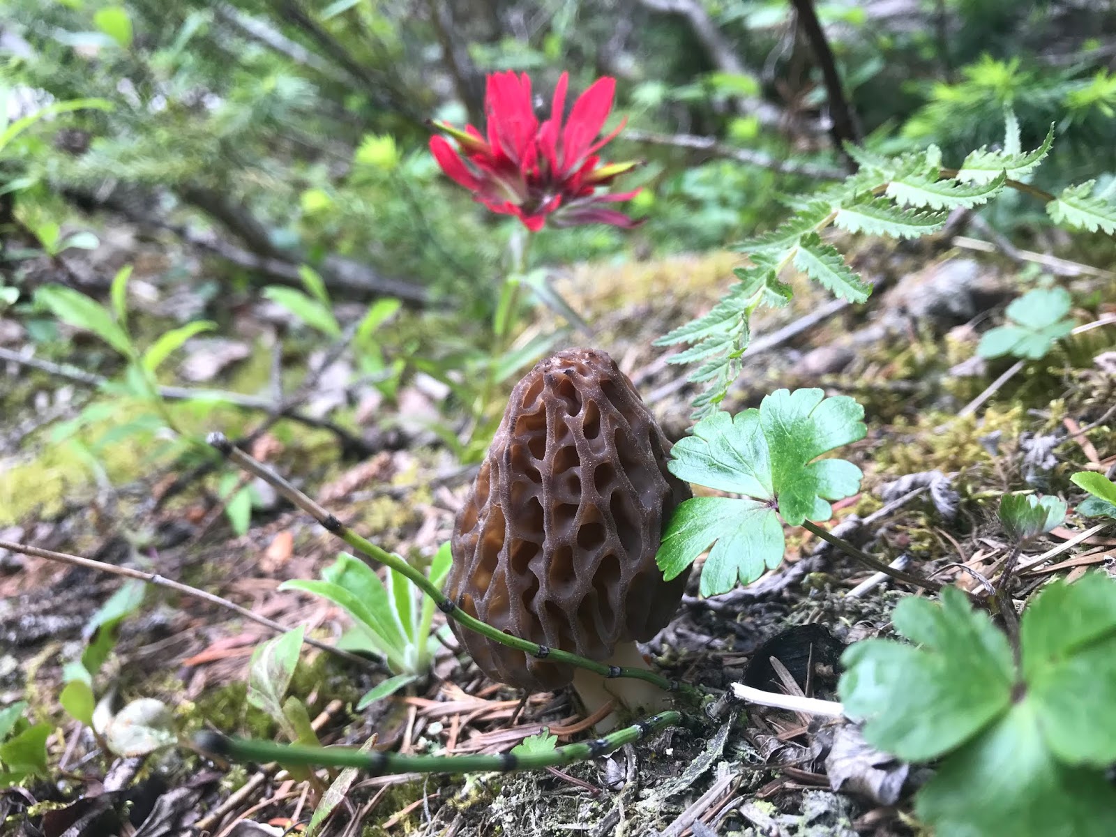
And there, tucked among the spruce, was the first morel we spotted this season. We left it alone since there was only one and we weren’t sure about the Canadian rules about collecting mushrooms.
After three miles we arrived at a great
overlook. We had a clear view of the
glacier clinging to the cirque high above us.
Across from us we could also see a waterfall cascading a few hundred feet down the cliff wall. Some hikers scrambled across the rocks to the base of the glacier and a few others scrambled towards the waterfall.
We thought about crossing the scree field but it had started to rain and Arleen came up with another plan! We retraced our steps and went to find a dry spot to wait out the rain.
We thought about crossing the scree field but it had started to rain and Arleen came up with another plan! We retraced our steps and went to find a dry spot to wait out the rain.


As has been the case on most hikes this summer, there were a few people on the way up
and quite a few people on the way back.
Even though it was cloudy, raining and chilly, we ran into a lot of
groups and the parking lot was packed when we got back to the truck.
The Storm Mountain Lodge and restaurant was just five miles back to the east. The restaurant was a nice cabin with rustic decor and a quiet atmosphere. Their food is made with fresh ingredients. We had a delicious smoked salmon cake and a bison burger.
The Storm Mountain Lodge and restaurant was just five miles back to the east. The restaurant was a nice cabin with rustic decor and a quiet atmosphere. Their food is made with fresh ingredients. We had a delicious smoked salmon cake and a bison burger.

In the afternoon we parked at the
Paint Pots parking lot. The parking lot
for Marble Canyon was being renovated for the 2019 summer. But there was a two mile trail connecting the
two areas.
First, we had to cross the pretty Vermilion River. Vermilion means red. The river gets its name from the red Paint Pots the river flows from in its headwaters but it is a brilliant turquoise color. It eventually joins the Kootenay River which in turn joins the Columbia.
First, we had to cross the pretty Vermilion River. Vermilion means red. The river gets its name from the red Paint Pots the river flows from in its headwaters but it is a brilliant turquoise color. It eventually joins the Kootenay River which in turn joins the Columbia.

We
walked the connecting trail that bordered the river. The trail was flat but rocky and muddy. We wandered out to a few islands to get
pictures of the dwarf fireweed that was peaking along the river.


The
trail led us to a surprise. The Marble
Canyon appeared suddenly! The 60 foot
wide river squeezes through a pretty 15 to 25 foot wide canyon. The water is
very clear but it is so deep in the canyon you can’t see the bottom. It looked like an inviting Calgon whirlpool!


11 July - Lake Louise
Lake Louise is considered the
premier jewel in the Canadian National Parks system.
I first visited Lake Louise when I was 14 as part of a tour with other 4-H Junior Leaders. I remember being astonished at the beauty of the lake. We only had enough time to see that there was a hiking trail up to a teahouse. I was immediately captivated and vowed that I would return one day to hike to the teahouse. It took over 40 years but I came back with Shawn and we hiked to two teahouses!
I first visited Lake Louise when I was 14 as part of a tour with other 4-H Junior Leaders. I remember being astonished at the beauty of the lake. We only had enough time to see that there was a hiking trail up to a teahouse. I was immediately captivated and vowed that I would return one day to hike to the teahouse. It took over 40 years but I came back with Shawn and we hiked to two teahouses!

“Lake
Louise, is a glacial lake within Banff
National Park. It is located 3 miles west of the Hamlet of Lake Louise and the
Trans-Canada Highway.
Lake Louise is named after the Princess Louise Caroline Alberta, the fourth daughter of Queen Victoria. The turquoise color of the water comes from rock flour carried into the lake by melt-water from the glaciers that overlook the lake.
Fairmont's Chateau Lake Louise, one of Canada's grand railway hotels, is located on Lake Louise's eastern shore. It is a luxury resort hotel built in the early decades of the 20th century by the Canadian Pacific Railway.”
We had heard you needed to be at the parking area before 7am to find a spot, otherwise you'd have to take a bus to get there. We wanted to take the bus from Banff, but the bus from our campground to downtown Banff and exchange to Lake Louise does not line up so it would take us almost two hours to get there and an hour and a half to get back. Plus, we wanted to do a lengthy 9 mile loop hike. So we decided to just drive ourselves which took us just under an hour.

We arrived at the Lake Louise
parking lot just before 7am and it was mostly full. We headed to the trail towards the huge
Fairmont hotel. I remembered sitting on
the porch during my previous visit.

As we looked towards the lake we
were greeted by a spectacular scene! The
brilliant blue-green waters were back-dropped by a dazzling rainbow slashing
across the mountains and glaciers at the end of the lake and reflected on the
calm waters!
We joined the few hundred other spectators there in the early morning hours to try to capture the scene. Just like my first visit, this scene will forever be captured on my mind’s eye.
We joined the few hundred other spectators there in the early morning hours to try to capture the scene. Just like my first visit, this scene will forever be captured on my mind’s eye.

We walked to the northwest shoreline
and saw the sign for the
Lake Agnes Teahouse trail. I knew it was the most popular one, so I planned to visit it first, and then take the high trail to the slightly less popular Plain of Six Glaciers teahouse.
The trail to Lake Agnes started climbing right away but was not overly steep. The trail was wide and in really good shape. There were other folks hiking up but we had left the majority of the crowd back at the lake.
As we twisted up the switchbacks we got glimpses of Lake Louise from time to time. We were amazed that with altitude the color became even more intense!

Lake Agnes sits at 7,000 feet, 1,300
feet above Lake Louise. We could see water
draining out and tumbling down into pretty falls just below the final scramble
to the pretty tarn.
Lake Agnes is more clear and a different color than Lake Louise. It is back-dropped by very rugged Mount Niblock and Mount Whyte.
The teahouse was built in 1901. “There is no running water and electricity. Supplies have to be transported manually by workers, via horse or flown in by helicopter.” We heard a few helicopters during our hike up.
There were about 100 people milling about, taking in the scene and drinking tea. We joined the line and waited about 15 minutes to get a table at the rustic teahouse. We sat outside, enjoyed a cup of soup with bread and a cup of tea from a perch overlooking the incredible scenery.


Fortified,
we hit the trail again and walked the northern shore to get to the base of the
Mount Niblock. From here we started up
the steep switchbacks to the Beehive.


From
the Beehive overlook, we were almost 2,000 feet above Lake Louise. We had an incredible view straight down to the beautiful lake and north to the ski resort area.

Next,
we headed down the cutover trail to the Plain of Six Glaciers Trail. The first portion was narrow, rocky, and
steep but we had it to ourselves.
However, once we joined up with the lower trail, the trail condition was better but we were once again with a steady line of folks. The last portion of the trail climbed a few switchbacks up into the trees.
However, once we joined up with the lower trail, the trail condition was better but we were once again with a steady line of folks. The last portion of the trail climbed a few switchbacks up into the trees.


“The name Plain of Six Glaciers comes
from the hanging glaciers of Mount Aberdeen,
Lefroy and Victoria, as well as the Lower Victoria and Lefroy glaciers and the hanging glacier on Popes Peak.”
The Plain of Six Glaciers Teahouse is a mile and a half from the upper end of Lake Louise just above the flood plain. It was built in 1927 and has been privately owned and operated by the same family since 1959.
We were more impressed with this more remote teahouse. First, it sees a lot less visitors than Agnes gets. Also, the food and tea was better. We each had a cup of soup and a half sandwich. And we had a big slice of chocolate mousse cake.
All the while we enjoyed the view of the alpine mountains draped in multiple glaciers. It was so worth the effort to get there.
The entire day was the realization of a dream from over 40 years ago. It was all the more special because my mountain man was with me and enjoyed it just as much as I did.


We
walked the three and a half mile trail back to the Lake Louise. Once at the lake, we stopped to soak our swollen
feet and ankles in the frigid water.

We
were not surprised but still amazed to see hundreds of tourists at the north
end of the lake trying to capture images of the jewel of Canada. We heard several different languages as we
pressed through the international crowd. Like most places, if you are willing to hike further than two miles, you
can escape the crowds.
Note: They only accept cash as method of payment at both teahouses.
Note: They only accept cash as method of payment at both teahouses.
12 July - Mount Norquay
“Mt. Norquay is a mountain and ski resort in Banff National Park, Canada that lies directly northwest of the town of Banff. The regular ski season starts early December and ends mid-April. Mount Norquay is one of three major ski resorts located in the Banff National Park.”

We
drove up and parked at the resort parking area.
We couldn’t find much information on the Stoney Squaw trail but one
reference said there was a loop hike that was hard to follow.
We started off on the trail directly behind the resort building and it quickly climbed into the woods. We found it easy to follow through the thick woods.
Most of the way there wasn't much of a view until we got to the front (south) of Snow Peak. From here the scene opened up to the eastern side of the valley but not of the town of Banff itself.


As
we drove down the six switchbacks, we stopped at a pullout and got a good picture
of Banff and the Bow River.

After we got back to the campground, we took a quick a walk to look at the hooddoos down by the Bow river. They're evidence of a volcanic past.


13 July - Cory Pass
Cory Pass Trail was the only trail
that was rated "difficult" that we planned to do in the Banff area. It was "only" 8.4 miles
long with 3,000 feet of climbing. That
was less than my rule of thumb of one mile/1,000 feet so we thought we should be
able to handle it. We've done a bunch of hikes like that!

The trailhead was only a short
distance from Banff so we were able to get an early start. Even so, the parking lot was already half
full.
The trail started out gently on an
old road. Then it shifted gears and
started up some steep switchbacks in mostly woods. Through gaps in the woods we had good
views down to the Bow River.


The trail climbs over the shoulder
of Mount Edith next to Mount Cory. As we
got above tree line, we had to maneuver around some rocky outcroppings. At times we were on all fours. I had to sit and jump down off some
rocks as we went up and down from one ravine to the next. Thankfully my mountain man was there to help me.


It leveled off a bit and
followed a rocky trail with a steep drop off.
We had an incredible view up to Mount Cory and back over the
valley!


We took a well-deserved long break at Cory Pass.


After climbing 3,000 feet, we
thought the challenge of the day was over.
Little did we know, we had to pass three tests as we rounded Mount
Edith’s back side before we could safely return to our truck.
We left our break spot, climbed the
last few feet of the pass and saw that we had to descend through a scree
field. We hate scree. Since the loose rock crossed the side of a
mountain, with every misstep, we sent bits of broken rock fragments
sliding down the slope and it threatened to carry us with it!


However,
that was nothing compared to the boulder field.
Here columns of mountain had cascaded down across our path. We had to climb over and around car-sized
rocks.


Next,
we ran into an area of avalanche zones where we had to climb over the
debris fields full of trees. The tall trees had been strewn haphazardly during huge snow
slides over several winters.


Finally, we walked into a dark
forest and were greeted by a calm forest trail. There were a lot of
roots. But they were nothing after passing
the three challenges.

We were thankful that the forecast for the next day called for heavy rain. We needed a break!

We were thankful that the forecast for the next day called for heavy rain. We needed a break!
We were exhausted when we made it
back to the truck. We had to agree with
the Park’s rating of the trail. It was
difficult!
15 July - Emerald Lake in Yoho National Park

Yoho National Park is just northwest of Banff National
Park. So it was easy to do a quick day
trip there. “Named for a Cree expression of
awe and wonder, Yoho lies on the western slopes of
the Canadian Rocky Mountains.”
Emerald Lake is
very appropriately named since it is a deep turquoise color due to its glacial
feed. It is very easy to pick out on
satellite.

We arrived early
but the parking was already limited.
Stratus and fog moved across the lake and obscured the mountain peaks we
knew were hiding all round us.
The plan was to first hike to Emerald basin, west of the lake and 2,000 feet higher, to view some waterfalls. As we walked the western shore, we were treated to the sight of a Loon couple feeding their fluffy chick!
The plan was to first hike to Emerald basin, west of the lake and 2,000 feet higher, to view some waterfalls. As we walked the western shore, we were treated to the sight of a Loon couple feeding their fluffy chick!

We cut over to the Emerald Basin Trail
which traversed a flat moraine for a little bit. Then the trail pitched up!
So we had rocks and roots to climb over.
However, as we neared the top, the stratus lifted. Now, The President and Michael Peaks revealed themselves.


However, as we neared the top, the stratus lifted. Now, The President and Michael Peaks revealed themselves.


Up in the basin we spotted a
dozen different waterfalls encircling 270° around us. We walked up the
center moraine which was not easy because it was littered with the boulders of
the decaying mountains. Boulder hopping my
least favorite hiking type of hiking.
The goal was to get near the two main Emerald waterfalls. Each had a field of snow with tunnels at their base. They slithered down hundreds of feet through narrow clefts.
There were a couple dozen people spaced out across the entire basin. We met more folks coming up the trail but they were spread out.


Then we walked around the east side of the lake. That was not nearly as pleasant as the west side.
First of all the trail did not go next at the lake. It was back in the woods where you didn’t even have a view of the lake. And it was a muddy mess.
There were lots of roots and very slippery muddy bogs. It is in dire need of some trail maintenance.
It was a bit of a shock to get back to trailhead where hundreds of folks wandered around visiting the concessionaires, taking pictures, and making memories.
We ended the day when I took off my boots, rolled up my pant legs and waded around in the pretty turquoise lake.


We noticed as we drove out that
there were cars parked on either side of the road for about a mile from the
lake. It is very popular!
16 July - Paget Lookout & Sherbrooke Lake
We returned to Yoho National Park to hike to Paget Lookout and then Sherbrooke Lake.
16 July - Paget Lookout & Sherbrooke Lake
We returned to Yoho National Park to hike to Paget Lookout and then Sherbrooke Lake.

We crossed over from Alberta into British Columbia and parked at the trailhead parking next to the pretty Wapta Lake. The lake was offset with a backdrop of Cathedral Mountain and Popes Peak. We knew there were glaciers hanging from the slopes but we couldn’t see them through the heavy hanging stratus.

We had to open a
gate in the wildlife fence to get on the trail.
The trail was littered with large rocks and we were thankful to have our
trekking poles as we stumbled along. After about 3/4 of a mile we came to a
split in the trail. If we continued
straight, we’d go to Sherbrooke Lake. We’d save
that for last so we took a right and headed up the side of Paget Peak.
The trail to Paget Peak immediately pitched up and stayed at a steady incline for almost two miles to the Lookout. It was also rocky in places but at times we walked across a smooth forest trail that we love.
The trail to Paget Peak immediately pitched up and stayed at a steady incline for almost two miles to the Lookout. It was also rocky in places but at times we walked across a smooth forest trail that we love.


After a total ascent of 2,200 feet, we arrived at the
Lookout. Mount Paget Lookout was built
in 1944 and is the oldest surviving fire lookout in the national parks. We
took a nice break on a new bench built out of snowboards. As we sat there we noticed some
mountain goat hair hanging in shrubbery nearby.
We hung out for a while hoping the clouds would lift across the valley. We took shelter in the lookout tower when a shower moved overhead. Thankfully, the clouds lifted a little and we got a better view of the incredible scenery around us.
We hung out for a while hoping the clouds would lift across the valley. We took shelter in the lookout tower when a shower moved overhead. Thankfully, the clouds lifted a little and we got a better view of the incredible scenery around us.


Then more clouds moved in, so we gave up and began our descent. We took a right at the main trail and headed to the lake. We were amazed at how pretty it was and at how quiet it was.
The day before we had been at Emerald Lake where there was a few thousand people milling around. Then, here at equally pretty Sherbrooke Lake, we only saw a handful of folks. A two mile hike is the separator between being jostled between tourists and having a peaceful experience in solitude.
Once again, we rolled up our pant legs and soaked our feet and legs in the very chilly water.

Finally, we made our way back along the mile and a half of rocky, root strewn trail that is protecting the calm and quiet of the area.
20 July - Moraine Lake
Moraine Lake is perhaps one of the most photographed lakes in the world. “Its waters are the most amazing colour, a vivid shade of turquoise that changes in intensity through the summer as the glaciers melt. Set in the rugged Valley of the Ten Peaks, Moraine Lake is surrounded by mountains, waterfalls, and rock piles, creating a scene so stunning it almost seems unreal.”

We decided to hike
up the three and a half mile trail to Eiffel Lake, above Moraine Lake, to get a
closer look at the Valley of the Ten Peaks.
We got a very early
start because of the popularity of Moraine Lake. There is a parking lot on Highway 1 where you
can catch a shuttle since parking at the lake itself is very limited. However, when we got there, the shuttle
operator encouraged us to drive up. When
we arrived at the lake 12 miles up the pass between Mount Temple and Panorama
Peak, we lucked out and got the last parking spot.
After days of rain,
low clouds and stratus still hung over the lake. It was a chilly morning and we hurried past
the lodging and concessionaire buildings on the shore of the lake. We looked forward to the almost 2,000 feet of
climbing to warm us up!

The trail started
out with a gentle climb but eventually pitched up and switchbacked. We had occasional peeks down to the lake
getting farther below us.
Despite the early
hour there were a number of other folks on the trail. However, at a trail split, nearly everyone
continued onto the Larch Valley Trail. We saw very few other hikers as we headed up Eiffel Trail.


The trail leveled
out along a shelf on the shoulder of Eiffel Peak. Below us we could see thick groves of Larch
trees. We imagined how pretty the hike
would be in the fall on a clear sunny day when the unique coniferous tree's needles all turn golden.
We could just make out the shape of mountains across the way playing peek-a-boo in the stratus.
We could just make out the shape of mountains across the way playing peek-a-boo in the stratus.

A short way before
the lake, the trail pitched up into the boulder fields of an old glacial
moraine. The glacier wasn’t there
anymore but we ran into lingering snow fields that we had to negotiate.

Finally, we spotted
pretty Eiffel Lake below us. Rather than
hike down to the lake, we climbed up on a large rock above the trail and took a
long picnic break. We took in the view
of the bits of visible mountain reflected in the deep blue lake. We could tell by its cobalt blue color it was
fed by primarily snow melt as compared to glacial fed turquoise lake right next
to it.


As we hiked back, the clouds started to lift giving us a better view of the incredible scenery all around us!


Once we returned to the tremendously popular Moraine Lake, we joined the throngs of tourists at the famous overlook at the north end of the lake. Hundreds of people jostled for position to get selfies of themselves or pictures of their loved ones with the pretty lake and mountains behind them.
All in all everyone was courteous and offered to take pictures of each other in exchange for photos of themselves. We tried to track all the different languages we heard. The chaotic activity was a shock after having been so isolated just hours prior. We got our picture taken and quickly made our way back to the truck.


We thoroughly enjoyed our short time in Canada. We had planned to visit more of their spectacular parks but we had family who needed our help.
We left Banff at the end of July. We spent just over a month in Montana preparing my Mom's house to sell. My sisters were able to move her to Colorado. I know she is safe now and hope she is happy.
Then, we spent a few weeks in Colorado visiting both of our mothers and other family members.
We returned to the mountains and Creede, Colorado in mid September. After Creede, we went home to Pagosa Springs, Colorado where we will settle down next year. We spent a month there making decisions that will impact our future.
Finally, we spent a week in Bluff, Utah. That blog will be out soon.
Next...
We are now in Kanab, Utah where we've spent time at the Best Friends Animal Sanctuary and have done some hiking.
Next, we visit Valley of Fire State Park and then Boulder City in Nevada. After that we head south into Arizona for a few months.
Parting shots...


(249,400)
You made the best of a difficult camping location. I can't parallel park a car, let alone a motorhome. A trailer would an impossibility for us. We still need help backing our boat down the launch ramp. I haven't been to Banff since 1971 but we have travelled by airplane to a lot of other Canadian places to camp. We are currently on a six week Snowbird RV Adventure from Bellingham to Los Angeles. We were hoping for lots of warm sun, but have had rain this last week and snow keeping us out of the mountain areas. Before that it was fires, so maybe this turn will help out on that front. We are new to RV life. If you are interested, you can follow the link over to my Margy Meanders blog. - Margy
ReplyDeleteMargy, I hope you are able to find some inspiration from our travels. We've been wandering for 8 1/2 years. Have fun this winter!
Delete