


Six days in Bluff, Utah...
Why we came...
Why we came...
To play in spectacular slickrock country and follow the steps of Ancestral Puebloans
The campground...
The campground...
Cadillac Ranch RV Park was
recommended by our travel friends, Garry and Karen. There are 14 gravel pull
through sites. They are long and
wide. Though, it would feel crowded if we had neighbors.
The first night we were there and
the last night we were there, a few other RVs pulled in. Otherwise, we had the campground to ourselves.
So it was nice and quiet! There is
very little highway traffic and we had one of the sites at the back of the
campground.
We had full hook ups. We disconnected
water each night due to mid-teen morning low temperatures.
There was decent Wi-Fi which was
good because there was a weak to nonexistent cell phone signal.
There was a seasonal worker that was
there one hour a day. She was friendly and wanted to help. But she was not able to refill our propane.
Showers and bathrooms were closed
for the season. Bluff has a laundromat but we did not go.
There were spectacular sunsets
against bluffs to south each night. Best of all there were lots of
adventures to be had within an hour.
 |
| Cadillac Ranch RV Park in Bluff was decent |
 |
| We had full hook-ups & decent wi-fi. It was mostly empty during our stay & quiet. |
Nearby towns...
Bluff sits at 4,324 feet and is a
small community of about 300. It is
spread out along Highway 191.
Though established in 650 AD, it was not incorporated till 2018. The first Mormon settlers arrived in 1880. On our first full day in town, we walked to Bluff Fort to learn more of their courageous story.
Despite its size, there are ten hotels, bed & breakfasts and even a few resorts. There are five RV parks though a few of them were closed for the season.
There are seven restaurants but a
few were closed for the season and others have odd hours. We ate at the Twin Rocks Café and were
impressed with their southwest/native cuisine fusion.Though established in 650 AD, it was not incorporated till 2018. The first Mormon settlers arrived in 1880. On our first full day in town, we walked to Bluff Fort to learn more of their courageous story.
Despite its size, there are ten hotels, bed & breakfasts and even a few resorts. There are five RV parks though a few of them were closed for the season.
There are only a few groceries at the two convenience stores. And other than a few gotch-ya shops, that’s it in Bluff.
Blanding, ten times the size with a
population of 3,690, is 25 miles to the north and has basic services. They even have a hospital and emergency room.
This corner of southeast Utah is
sparsely populated with very little between the ancient sand dunes that adorn
the landscape.
Adventures...
Bluff Fort, Twin Rocks, Sand Island Petroglyph
“The
original Bluff Fort has been rebuilt and lovingly restored and is open to
visitors free of charge. You can learn more about why the pioneers
came to Bluff and their arduous journey over the Hole-in-the Rock trail.”
In
October 1879, 70 families with about 250 men, women and children left
Escalante, Utah which is only about 116 miles as the crow flies. It would take them seven months to cross the
Colorado River canyon and to go that distance.
“Using a route advised by a previous scouting party known as the “Escalante short cut”, the pioneers expected the 125 mile trek would take 6 weeks. Instead, the journey extended 260 miles via the Hole-in-the-Rock-Trail in arduous, winter conditions.
To allow wagon passage, the men spent 6 weeks blasting and chiseling a path through a narrow, 1,200 foot drop in the sandstone cliffs known as the Hole-in-the-Rock, which is still visible at present day Lake Powell.
We really enjoyed wandering around the open square of restored cabins and reading the stories about the pioneers and their challenges. An example is getting basic irrigation set up which was a formidable challenge. Then, because of the power of the San Juan River in the spring due to melting snows in the Rockies, they had to reconstruct the system each year.
We really enjoy those stories. They make us so grateful for our modern day luxuries.
Afterwards
we walked through town pausing at each marked historical home. We went to the Twin Rocks Trading Post to buy
a book. Then we noticed a trail leading
away from the parking area. Well, we had
to follow that!
In
the afternoon we drove to the Sand Island Campground and Boat launch three
miles west of Bluff. It is down in the
San Juan River bed area. There are 27
camping sites.Only a short walk
away is the Sand Island panel. It “is an
impressive rock wall that stretches more than 100 yards, and is covered with
ancient Anasazi scrawlings, estimated to be anywhere from 800 to 2,500 years
old.” |
| Bluff Fort was settled around 1880 after a challenging journey from Saint George UT |
 |
| Bluff Fort. On the left is a wagon home. A few settlers spent years living out of a wagon. |
 |
| Inside the old school house |
 |
| Checking out the impressive "Twin Rocks" |
 |
| Just an easy short walk gets you "behind the rocks" |
 |
| Just a few of the many petroglyphs at Sand Island |
Natural Bridges...
What’s the difference between an
“arch” and a “bridge”? Arches are carved mainly by frost action and
seeping moisture. Bridges are formed solely by moving water. Arches
are much more common than bridges.
The nearly 9 mile loop hike was
incredible! We did it backwards from when we were here six years
ago. Then, we dropped into Sipapu
first. That was one of the most
impressive part of the hike. We’d save
it for last this time.
There are three bridges in a canyon shaped like a “C”. The first section of the hike traversed along the top from one side of the monument to the other making our route look like a “D”. It was pretty much like a roller coaster. It was predominantly across slickrock which we really enjoy. We did have to keep an eye out for the little cairns guiding us to the next section of trail.
After over two and a half miles of trekking a straight line across the slickrock, we saw the road and the Owachomo Bridge view point. Only a half dozen folks were making their way half way down the trail to look at the best vantage point of the bridge. From the top it is hard to see against the similar colored rock.
However, as you drop into the canyon, it appears against the blue sky. Merely 9 feet thick, Owachomo appears to be on borrowed time. The reflected light from the slickrock made the delicate bridge appear as if were glowing against the brilliant blue sky.
After passing under Owachomo, we descended 500 feet into the canyon. We were completely alone. We followed a trail along the wall a few feet above the floor. We could see the floor of the canyon itself was littered with rocks and boulders from the floods during monsoon season.
We followed the trail for three and a half miles to the bulkiest bridge: Kachina. Along the way, we got a little confused and ended up on the left side of the canyon and the trail cliffed out. After backtracking, we could see that the canyon dropped suddenly and that during monsoon there is a dramatic waterfall that is probably visible from the Kachina Bridge view point, 500 feet above. We had to climb halfway up to the view point to avoid the deep crevice and then climb back down into the canyon.
Finally, we passed under the Kachina. A couple was relaxing underneath. They were the first and only people we saw in the canyon all day. We paused just for a moment to take in the golden reflection on the underneath side of the bridge.
It was another mile and three quarters hike through the winding canyon to Sipapu Bridge. This section of the canyon is most dramatic with more colorful walls. Along the way, we stopped to appreciate the view of Horse Collar Ruin on the canyon wall.
Then we came to the dramatic view of Sipapu Bridge. It is the largest natural bridge in the park and the second largest in the United States. It spans 268 feet at a height of 220 feet. We tried but it is so difficult to get a decent picture of it from below. It is something you have to see with your own eyes.
Finally, we ascended about 500 feet to the rim. The climb up was fun and entailed negotiating two or three stick ladders.
Natural Bridges National Monument should be on everyone’s “must see” list. And do yourself a favor and get down into the canyon, to admire a bridge from below. Owachomo is the easiest one to get to and is worth the effort!
 |
| Hike route in Natural Bridges |
 |
| Good morning Natural Bridges! |
 |
| See Owachoma Bridge? |
 |
| Arleen under Owachoma Bridge |
 |
| This was our lunch spot about half way into our 9 mile hike. The pic doesn’t capture the immensity of the sandstone cliffs. |
 |
| Horse Collar Ruin was abandoned over 700 years ago |
 |
| Climbing back out of the canyon above Sipapu Bridge |
Moki Dugway, Muley Point, Valley of the Gods, and The Goosenecks…
We
set out to explore the area west of Comb Ridge.
We started out by driving up the Moki Dugway. The dugway “was
constructed in the 1950’s to provide a way to haul ore from the Happy Jack Mine
on Cedar Mesa to the mill in Halchita, near Mexican Hat.”
“The
Moki Dugway is a staggering, graded dirt switchback road carved into the
face of the cliff edge of Cedar Mesa. It consists of 3 miles of steep,
unpaved, switchbacks (11% grade), which wind 1,200 feet from Cedar Mesa to
the valley floor near Valley of the Gods. Scenic views of Valley of
the Gods and distant Monument valley open at every turn of the dugway."
As we approached on the paved Hwy 261, we could not see where the dirt road would its way up the sheer cliff. Even as we started climbing, it was difficult to discern where the switchbacks were. Finally, a vehicle above winding its way down gave us a clue. Incredible!
Once, on top of the Cedar Mesa, we took a left on Muley Point road and followed the sandy road out to Muley Point and the edge for 5 miles. We got out of the truck and walked the edge and peered 2,300 feet down into the canyon and the San Juan River. Muley Point and the canyon below are part of the Glen Canyon National Recreation Area. About 40 river miles from here the San Juan empties into Lake Powell.
Then, we drove back down the Moki Dugway. We were thankful that we only had to pass a few vehicles.
Next, we turned off Hwy 261 and into the west entrance of Valley of the Gods or little Monument Valley. The red dirt road winds 16 miles through several sandstone formations with whimsical names such as Castle Butte, Setting Hen Butte and Seven Sailors.
“The statuesque formations are sculpted from Cedar Mesa sandstone dating to the Permian period, around 250 million years ago. Eroded by water, wind and ice over millions of years, the rock was carved into the unique buttes, monoliths (single massive stone or rock), pinnacles and other geological features as seen today.”
Finally, we retraced the miles back on Hwy 163 and Hwy 261 to Goosenecks State Park. We drove in past the camping spots to the far side of the park. We walked the distance back to the view point taking spectacular in the view along the way.
“The Goosenecks of the San Juan River are a series of tight loops– or “goosenecks”—made by the river as it flows towards the Colorado River. Geologists refer to these loops as entrenched or incised meanders. The San Juan River has carved a 1,000 foot (300 m) deep gorge here. Over a distance of 1.5 miles “as the crow flies”, the San Juan River flows more than 6 miles through the loops of the goosenecks.”
After reading about the Goosenecks on the interpretive signs, we squeezed down through a few rocks and followed a trail a quarter of a mile and 500 feet elevation down to a ledge for a better view. We stood for a while taking in the marvelous scene still 800 feet below us. We could clearly make out the clear water as it wound through the steep walls and through occasional rapids.
 |
| The warning at the bottom of the Moki Dugway |
 |
| About half way up |
 |
| See the switchbacks? |
 |
| Nearing the top |
 |
| The view towards the east from near the top |
 |
| Muley Point - the San Juan River flows through that chasm. Monument Valley is in the distance. |
 |
| Another view from Muley Point |
 |
| Looking southwest from Muley Point. Navajo Mountain, 10,387ft, is in the distance. |
 |
| Valley of the Gods |
 |
| Valley of the Gods |
 |
| Sweet camp spot in the Valley of the Gods |
 |
| The Goosenecks of the San Juan River |
 |
| A sweet camp spot high about the San Juan at the Goosenecks |
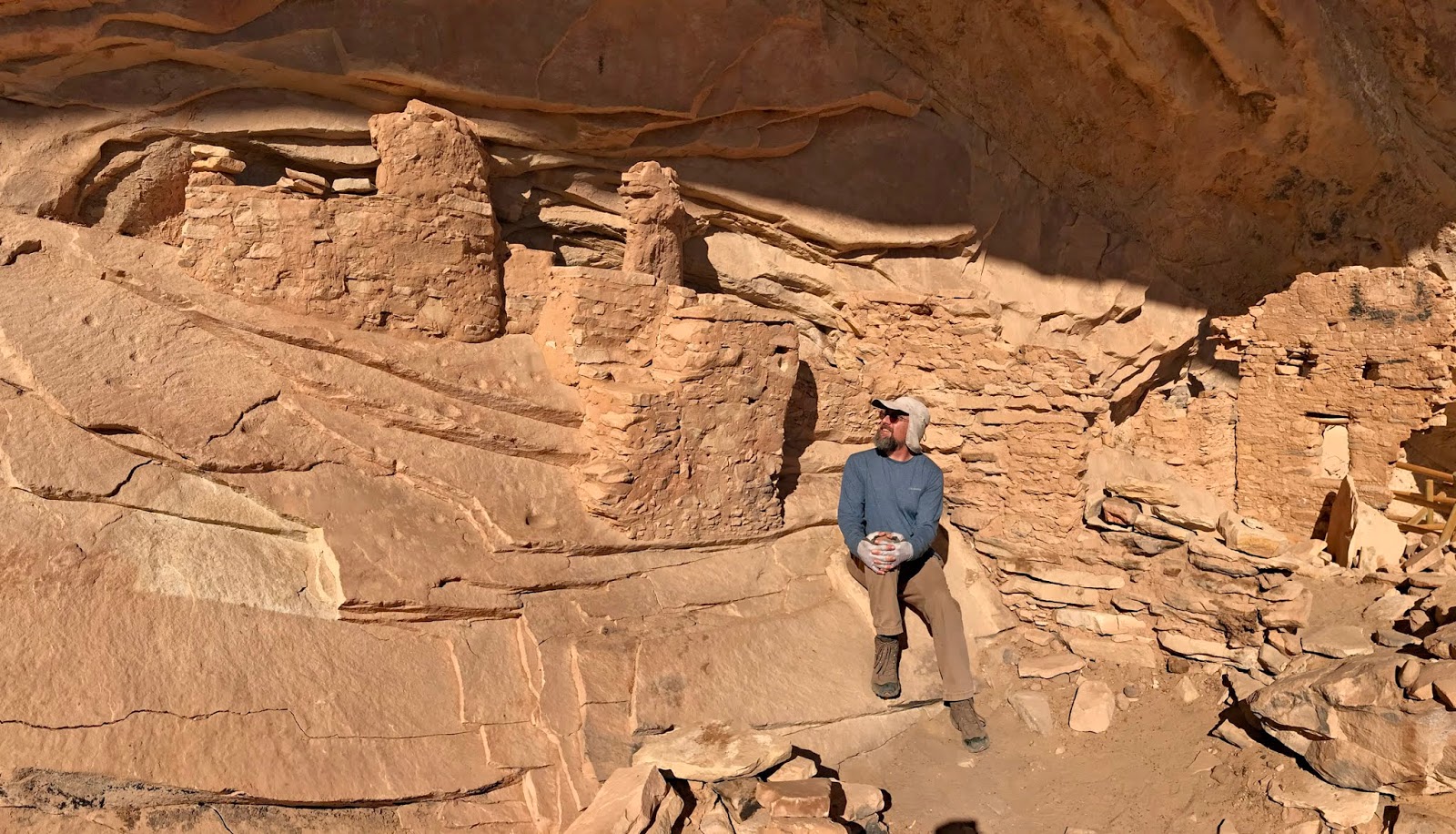
Kane Gulch and Grand Gulch
We
set off for an adventure of canyon hiking to look at ruins and pictographs. “Grand Gulch was occupied by Ancestral
Puebloan Native Americans between 800 and 2,000 years ago. Ruins from this
period may be found built in protected areas such as under overhangs and in
alcoves in the cliffs. Their rock art decorates cliff faces and protected
alcoves.”
To get there we had to climb the Mok Dugway road for the third time that week. We parked at the Kane Gulch Ranger station.
“The Kane Gulch Ranger Station is located within the Bears Ears National Monument in Southeastern Utah, an area well known for its cultural resources. The Ranger Station is at the Kane Gulch Trailhead, which leads into Grand Gulch, where hundreds of Ancestral Puebloan ruins exist in a backcountry setting which is toured by backpackers. The Ranger Station itself is a destination, where interpretive displays include photographs and drawings of numerous prehistoric sites, primarily rock art, and of archeologists at work.” Though it was closed for the winter when we there.
The hike starts right across the street. The mile was through a ephemeral creek bed with tall dry grasses on either side of us.
As the trail started a gentle descent, we passed through splits in the rock. We continued to drop and the crevice widened. Amazingly, an aspen grove of several hundred trees flourishes in this desert climate where fresh springs provide continuous watering.
Shortly, after passing the grove, the white and pink walls of the Cedar Mesa Sandstone rose above us, we moved easily across the smooth slickrock left smooth by the annual monsoon season. Now, there were only odd pools left. On this cold November morning, they were iced over.
At about the two mile point, we had to take a cairn marked trail to make our way around a huge boulder field and a long dropoff. Here the canyon was over 100 feet wide and the walls rose 250 feet above us.
It was through this section, we met a group of eight backpackers who had been the canyons for 2 weeks! They were on the final day. They would be the only other people we would see all day long.
We continued to drop till we came to the impressive Kane Gulch and Grand Gulch intersection. Now the canyon floor was as wide as 250 feet and top of the walls were difficult to see as they towered 600 feet above us!
At the intersection, we made our way along the faint trail through the cottonwoods and grass to look up at the Junction Ruins.
“This extensive set of ruins is built on three levels of an east/southeast facing alcove along the canyon’s west wall. The interesting complex consists of storage units, habitation rooms, kivas, cists (burial chambers) and defensive structures. The construction techniques include wet and dry laid adobe masonry and wattle and daub (mud plaster laid over a matrix of sticks). The ruins were stabilized in 1966 and 1984.”
Afterwards, we continued to venture further into the canyon. At four and a half miles we found a trail cut through the deep sand that took us to a steep trail the climbs to the Turkey Pen Ruins.
“The alcove contains a number of structures along with some pictographs. At the eastern end of the alcove chains protect a kiva that is mostly filled with sand. Toward the western end of the alcove is the “turkey pen,” where branches from willows or some other type of thin reed are placed in a circle to create a cage of sorts.”
Although we retraced our steps back up the canyon, when we had dropped in, it had been cloudy. Now, it was only partly cloudy. The sun changed and intensified the colors of the walls soaring above us. We even paused to reshoot pictures we had taken earlier in the day.
 |
| Hike route down Kane Gulch and into Grand Gulch |
 |
| We were surprised to see a grove of aspens in Kane Gulch |
 |
| A narrow cleft in the early part of the hike |
 |
| We love the amazing sandstone formations |
 |
| Are we on Mars?! |
 |
| This is the final tough descent in lower Kane Gulch |
 |
| Junction Ruins are at the junction of Kane Gulch and Grand Gulch |
 |
| We spotted these ruins on the way back. How the heck did they get up there?! |
 |
| Approaching Turkey Pen ruin |
 |
| Turkey Pen ruins - the circular pit was a kiva. It would have had a roof. |
 |
| Ancient art at the Turkey Pen ruin |

 |
| We had to avoid a couple of frozen puddles |
 |
| An incredible scene! The colorful sandstone cliffs are hundreds of feet high. |
 |
| More incredible rock formations - we love it! |
 |
| A keyhole rock on Mars? |
Wolfman...
On
our last day in Bluff, we set off with an ambitious plan of exploring a number
of ruins, petroglyphs, and pictographs hidden along the spectacular Comb Ridge.
“Tilted at
an angle of almost 20 degrees, Comb Ridge is an ancient rock formation tapered along the desert landscape of southeastern Utah. A
linear north to south-trending monocline, this immense sandstone formation is
nearly one hundred and twenty miles long and one mile wide.
In the Navajo tongue, this
cataclysmic upheaval of earth is translated “Rock Extends in the Form of a
Narrow Edge.” This blunt rock extension occurred nearly 65 million years
ago, when tectonic plates buried deep under the earth’s surface slipped,
leaving a rugged scar across the face of the once smooth stone.
These jagged and weathered crags
sharply ascend up steep summits then drop into unexpected depths with
staggering and sudden recurrence. They loom from 300 to 900 feet above the
empty plains, before disappearing into the surrounding washes.”
“Ancient
Ancestral Puebloans once found refuge in the Comb’s alcoves. Their
existence may be found today as ruins and rock art on the canvas
of shallow cave walls. Archaeological
surveys of Comb Ridge have revealed more of the formation’s ancient secrets,
from Ice Age camps and 800-year-old Ancestral Puebloan cliff dwellings, to
historic artifacts of Anglo settlers, and strange lanes carved into the earth
across miles of desert, scattered with remnants of Hopi pottery.”
We drove west out of Bluff and took
a right onto the Butler Wash Road. There
was a sign that warned that the road during or soon after rain could be
unpassable and that 4-wheel drive was recommended. We ventured forward in our big Ram.
First, at about a mile, we saw a
fence near a cattle grade. We could see
the deep sand spur road that led to the trailhead for the Wolfman Panel. We knew this from studying a trail
guides. There weren’t any signs. We just backed into a spot near the cattle grade
and walked the spur road.
We walked a short distance across the slick rock till we came to wash ledge. We peered down into the wash filled with willows. Across under an alcove we saw the ruins.
We followed the few cairns to a part in the rocks to reveal a steep rocky trail. We dropped down to it and cautiously followed the trail along the edge of the wall till across a small gully we could make out the petroglyths.
They were some of the most impressive and unique petroglyths we have seen; men with huge feet and hands, birds, canine footprints, and other carvings. We mused with a few other folks there as to what they might be.
While the other folks headed back up the trail, Shawn and I headed down to find our way to the ruins. It was not easy to get through the willows. But we eventually found a trail so it was easier going back! The last portion of the trail was a steep portion of trail in deep sand. The ruins were worth the effort to get there.
These ruins were formed with more mud than rocks like other ruins in the area. They resemble the same shape as honeycombs. What surprised us was the amount of pottery shards and corn that were setting out on the remains of some of the walls. It was good to see that when pieces of pottery were found, they were left behind for others to see rather than being taken home as a souvenir.
We headed back up to the parking area by a different but easier route. We followed the trail and made it easily through the thick willow.
 |
| Approaching the south end of the 80 mile long Comb Ridge |
 |
| Hike route to the Wolfman Panel and ruins |
 |
| Butler Wash |
 |
| Wolfman ruins |
 |
| A few of the amazing petroglyphs on the Wolfman Panel |
 |
| Wolfman ruins |
 |
| Wolfman ruins |
Doublestack...
Back at the truck, we continued
north on the Butler Wash road for almost another three miles. We parked near a couple of boon dock
campsites. Again, there isn’t a sign for
the Doublestack Ruins. We used the
Alltrails app to find the exact location.
The trail was pretty easy to follow
after we made our way across the main wash.
The sand is deep in a few spots and we had to climb in and out of a
number of secondary washes. As we
approached the ruins area a little more than a mile from where we parked, there
was a network of trails branching off.
We took the trail that headed towards the large overhanging alcove.
The Doublestack ruins get their name
from the two story apartments, though there is only one wall that remains of
the two stories. We saw remains of a kiva,
granary and a spit that may have been used to dry game meat. We really liked the quiet canyon this family
had picked to build their homes.
The top of the Comb Ridge called to
us. So rather than following the trail
back, we found a great slab of slickrock that angled towards the sky so we
followed it to top of the Comb. From
here, we had a great view. We could
imagine ancient hunters used this spot to scope for deer in the cottonwoods and
tall grasses in the wash below us. We
took a long break and enjoyed the scene.
 |
| Hike route to the Doublestack ruins |
 |
| These teepee like structures were thought to be used as caches and emergency shelter |
 |
| The Doublestack wall on the far right is at least 10 feet high |
 |
| Petroglyph at Doublestack ruins |
 |
| Pondering what it was like to live here hundreds of years ago |
Next...
We are in Kanab UT and head to Valley of Fire State Park NV next. Then we'll spend two weeks in Boulder City NV hanging out with good friends.
We are in Kanab UT and head to Valley of Fire State Park NV next. Then we'll spend two weeks in Boulder City NV hanging out with good friends.
Parting shots...
 |
| Cows near the Valley of the Gods. Monument Valley is in the distance. |
 |
| The Mexican Hat is a famous landmark |
 |
| One of the old sandstone houses in Bluff |
 |
| A petroglyph at the Wolfman Panel - see yah! |
(250,630)
So, who established Bluff in 650AD? That is pretty early even by European standards...
ReplyDeleteJanet-Anne, the Ancestral Puebloans arrived in the area in 650AD. Before the Mormon settlers in 1880, Spanish explorers and some odd outlaws are the only Europeans to have known to have traipsed through the area. - Arleen
Delete