Home is where we are parked

Home is where we are parked

Tuesday, November 15, 2016

AZ -- Lees Ferry, 20-26 October 2016

Map picture
Map picture

Six days at Lees Ferry, Arizona…

Why we came…

We visited Lee’s Ferry four years ago. We were only there for an afternoon to fly-fish the Colorado River. We both fell under the spell of the river and the dramatic Vermillion Cliffs. We vowed to come back to do a multi-day kayak trip and to hike the historic Spencer trail.

The campground…

Lees Ferry Campground has 54 sites. It looks like it was designed forty years ago. A lot of the sites are short and narrow. We chose one of the longer pull through sites though there were a couple of nice sites along the cliff with a great view of the river. Our site was a bit unlevel, composed of gravel and shaded with a few small trees. We also had a picnic table and fire ring. There are no hook-ups but there are two older bathrooms (without showers) that were kept fairly clean. Surprisingly, we had a decent Verizon cell phone signal. There is a single dump station with potable water a mile from campground.

The campground is “first come, first served”. The campground was about half full when we arrived on a Thursday afternoon. By Friday afternoon, the campground was full.

We were comfortable and would return. Like most places, it would be best to go during the “shoulder seasons” and during the week.

Lees Ferry45-25 Oct 2016

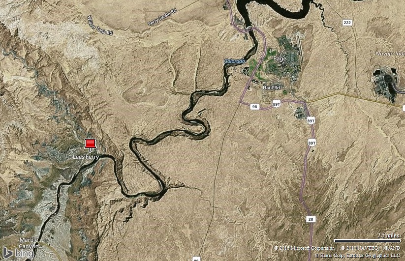
Lees Ferry on the Colorado River about 15 miles below Glen Canyon Dam

Lees Ferry5-20 Oct 2016

Our camp spot at Lees Ferry

Nearby towns…

Page, Arizona, population 7,247 and elevation 4,118 feet, offers about 30 restaurants, a big Walmart, a nice Safeway grocery store, and other services.  It’s a circuitous 45 mile drive from Page to the Lees Ferry Campground.

The tiny little communities of Marble Canyon, Cliffhouse, and Bitter Springs are closer and offer a couple of restaurants, gas stations, some lodging, a post office, and a laundromat.

Adventures…

21-24 October we kayaked the Colorado River…

I planned a four day, three night kayak trip that would allow us to take our time and fully explore the river and the canyon. There is no access to the fifteen and a half miles of river squeezed between majestic 700-1,500 foot Navajo sandstone cliff walls from the Glen Canyon dam downstream to Lee’s Ferry. That section of the Colorado River moves along steadily with just a few bumpy riffles making it perfect for a peaceful float adventure.

We met Mick Lovett from Marble Canyon Outfitters late Friday afternoon. Mick helped us and two other ladies load our kayaks and gear on his river boat. Next, he showed us a map and discussed the various camp spots. He was on the river most of the day and knew which camps would have open spots.

Primitive camping on the river is limited to 14 days. “Camping is permitted in designated areas only. There are six designated areas, marked with signs, on a first-come first-served basis. Upriver campsites are provided with toilets and three fire pits. All campsites are located well above the river and require a short walk from your boat.”

As we headed up river, Mick briefed us on the best fishing spots and areas to explore during our adventure. He graciously allowed us to unload the gear at the camp spot closest to the dam, Ropes Trail camp. Then he took us up near the dam where we unloaded our kayaks.

Lees Ferry 21-24 Oct 2016-kayak    Lees Ferry7-21 Oct 2016

Four day long kayak route on the Colorado River  /  Mick, our shuttle captain, explaining things on the map

Arleen and I slowly paddled a couple of hundred yards upstream to fish in the shadow of the dam while the ladies floated towards the camp.


Before we left, we got a fishing report at the nearest fly shop. The fishing was rated “fair”. That, in fish speak, is bad news.


I tentatively tied on a San Juan worm and after five minutes of letting it drift down from a gravel bar, I had a good hit. I pulled in a nice, fat 16” rainbow. Arleen and I were both excited and were hopeful that the fishing report was too pessimistic.

Lees Ferry8-21 Oct 2016

Arleen fly-fishing the Colorado River just below Glen Canyon Dam

Lees Ferry9-21 Oct 2016    Lees Ferry10-21 Oct 2016

Caught a nice rainbow trout

The sun was sinking fast, so we called it a night and paddled a mile downstream to our stuff waiting for us at the Ropes Trail camp. As we set up our tent, darkness quickly filled the narrow canyon. We had a snack, and crawled in our net tent as the stars filled the sky.


We shared the area that night with a family of five and the two lady kayakers. The camp spots were separated by thick desert shrubs so we had privacy. Once everyone turned in, it was very peaceful.

Lees Ferry19-22 Oct 2016    Lees Ferry12-22 Oct 2016b

We spent the first two nights at the Ropes Trail Camp  /  Petroglyphs near the camp

We got up early the next morning. As I walked up river, I saw a boat with 2 Labrador Retrievers leaning over the bow as it ran up river. A few minutes later I heard a shotgun fire a few times followed by a few splashes. That reminded me that duck hunting season begins last week October.

I spent a few hours fishing from a sandbar. Unfortunately, I did not have any hits. Oh, no, was the fishing report true?

As I fished, the first of many Colorado River Discovery boats floated by. We heard the guide mention something about an actual rope ladder on the cliffs. Arleen and I set off on the slick rock to find it.

As we climbed up the slick rock, we saw that it was not one solid cliff of sand stone. But rather it was a series of fins oriented next to and stacked on top of each other. It was possible to move from one fin to the next, climbing higher and higher.

We could see that the family had made it all the way to the top of the cliff! We were not able to figure how they were able to do that. We took a break a few hundred feet above the river and listened to the Discovery boat guides brief that the area was used by natives for centuries to get to the river.

Usually wilderness areas are quiet and peaceful but we heard quite a bit of small airplane noise during the day. Later we learned that the Page airport was only two miles away. Between the boat traffic and airplanes, Glen Canyon was not too peaceful during daylight hours.

Arleen and I made the decision to stay put another night rather than packing up and floating downstream to another camp site. The ladies had left early and the family of five departed in the mid-afternoon. We had the entire campsite to ourselves until we left the next morning.

We launched the kayaks and fished a perfect big, slow eddy for several hours. But in that time I only hooked one small rainbow on a woolly bugger. Rats, we were proving the fishing report to be accurate.

We hiked up the cliffs again in the afternoon. This time we found the, “rope”. It was not made of plant fibers as the natives would have used. But rather, it was a thick steel cable. You’d use it to “walk up” or rappel down the slick rock in the steeper sections.

Lees Ferry11-22 Oct 2016    Lees Ferry18-22 Oct 2016

Me fly-fishing near the camp the first morning  /  A lizard enjoys a snack

Lees Ferry13-22 Oct 2016

Fishing a riffle downstream of the camp

Lees Ferry15-22 Oct 2016    Lees Ferry16-22 Oct 2016

Exploring the slick rock above the Ropes Trail Camp

Lees Ferry17-22 Oct 2016    Lees Ferry23-22 Oct 2016

A hawk soaring over the river  /  Enjoying an evening walk.  Our camp is in the shrubbery below

Lees Ferry20-22 Oct 2016

Exploring the Colorado River near the Ropes Trail camp

Lees Ferry21-22 Oct 2016

Arleen fly-fishing the big slow eddy near the Ropes Trail camp

We packed up the kayaks the second morning and hit the river. We were curious about the other camps and made it a point to check out each one. The Ferry Swale Camp is a large flat area. There were a few dozen tents set up by a large children’s rafting camp…it was a zoo!

We also stopped at a couple of day use spots to walk short paths to see ancient petroglyphs. Some of the engravings were obvious and some seemed cryptic. They always give us a small peak into their mysterious past.

As we floated, we drift-fished. Sadly, neither of us got any bites. At the next camp we found the reason why.

9 Mile camp sits directly below the famous Horseshoe Bend overlook. We could see a bunch of tiny tourists over a thousand feet above us.

The United States Geological Survey (USGS) had a large camp set up at 9 Mile. There were at least a dozen scientists camped there while they did studies of the river, plant life, and fish. Apparently they were electro shocking the trout and gathering detailed information. The zap is only supposed to last a few minutes but my theory is that the fish were lethargic and sulking deep in the water.

We checked out 8 Mile camp, too, but thankfully pushed on to 6 Mile camp. Till late at night, we would hear the scientists racing their boat up and down the river as they tried to spotlight fish in the dark. At 6 Mile it was more of a distant irritant. At 8 Mile, the researchers and their noisy boats would have kept us awake much of the night.

Lees Ferry25-22 Oct 2016b   

Reading in the tent  /  Headed to the next camp site on day 3

Lees Ferry27-23 Oct 2016b

Stopped at the beach at the Ferry Swale Camp

Lees Ferry28-23 Oct 2016b

A horseshoe bend between Ferry Swale and Nine Mile Camps

Lees Ferry28-23 Oct 2016    Lees Ferry29-23 Oct 2016

Petroglyphs at that horseshoe bend  /  A fishing break

Lees Ferry31-23 Oct 2016

A beautiful spot just upstream of the Six Mile Camp

On our third and final night, we had 6 Mile camp to ourselves! It was Sunday evening and all of the boats appeared to be leaving the river as the weekend came to a close.

There was one very nice camp site with a great view of the river but it was a steep hike up deep sand to get there. Arleen and I were both a bit stiff so we settled on the most convenient camp spot.

Last year we purchased a Kelty TrailLogic tent. It’s noted most for the, “roll-up Stargazing Fly™ for nighttime enjoyment”. Compared to our pervious tents, we struggled to set it up. To keep things simple, we had been keeping the rain fly off and thoroughly relishing the incredible night sky from the comfort of our sleeping bags.

Though there were just a few clouds as we ate dinner, we expected rain during our final night. So, before we tucked into our sleeping bags, we added the rain cover but rolled up the “Stargazing Fly”. We could still see the stars, moon, and clouds, but would supposedly be able to rapidly close the Stargazing Fly if needed.

Sure enough, about three in the morning, we were awakened by rain drops on our faces. Even in our sleepy state it only took us a couple of minutes to fully secure the rain fly! We relieved ourselves and settled into our dry tent. It rained briefly a few times and there were a few flashes of light and cracks of thunder, but we slept peacefully and stayed dry.

Lees Ferry32-23 Oct 2016

Camped one night at Six Mile

We thoroughly enjoyed the float the next day from 6 mile to 2 mile. The canyon walls seemed even taller with more geological variety. There was a toilet river-right at 4 mile, though there weren’t any fire rings. On river-left, a prominent drainage joined the Colorado River that was tempting to explore.

A fellow fisherman, one of the few on the river this day, said they were hooking fish on San Juan worms. There were two great fish runs near 4 mile, one with good drop off. Arleen and I fished them for a couple of hours from both the kayak and by wade fishing. Finally, I caught a couple and Arleen caught one nice rainbow.

We paddled the last two miles with very little assistance from the river. We were thankful that there wasn’t a headwind! The current is very slow in this section which is one reason why John D. Lee chose this spot for his ferry. We pulled up to the boat ramp at Lee’s Ferry just as the afternoon showers moved into the area. Once again, our timing was impeccable.

Lees Ferry34-24 Oct 2016

Floating and fishing on our last day

Lees Ferry38-24 Oct 2016    Lees Ferry37-24 Oct 2016

We each caught a trout here on the last day

Just two or three miles from Lees Ferry

On 25 October  we hiked the Spencer Trail…

We heard about the historical Spencer Trail several years ago. The trail was named after Charles Spencer who was in charge of the gold mining operations in the area conducted in the late 1800s. He built the Spencer Trail to transport coal to the mine from Utah.

Each time we had been near the area, we carefully scanned the 1,500 foot high sandstone cliffs for the trail.

We set off to tackle the trail with some trepidation and a good amount of nervous energy. We had heard that just a short ways up, you get a great view. So we agreed that if the trail proved to be too much, we would enjoy the view, turn around, and return to terra firma.

We grabbed our backpacks and trekking poles and hit the trail. First, we followed the interpretive trail past some the ferry’s historic buildings. After a quarter of a mile, we turned up the steep rocky trail.

As we scrambled up, the trail materialized in front of us. It switch-backed and climbed steeply. It was rock-strewn and we had to watch our footing but the trail was easy to follow. As we progressed, the view of the river, the Vermillion Cliffs and Glen Canyon improved.

Finally, we crested the top of the sandstone plateau, 1,500 feet above the Colorado River. We had an outstanding view towards the northeast of the deep canyon, Page, and could see slivers of Lake Powell in the distance. We wandered around the top for a while peering into the canyon to see where we had recently floated and camped.

We probably took more time hiking down the trail, than up. It was steep and a wrong step could easily result in injury. It was a challenging and physical hike, but worth the epic view!

Lees Ferry-25 Oct 2016-hike    Lees Ferry53-25 Oct 2016

Hike route up the Spencer Trail  /  We spotted this three foot long rat snake by the trail

Lees Ferry41-25 Oct 2016

Original buildings from around 1900 for the ferry operation

Lees Ferry43-25 Oct 2016    Lees Ferry44-25 Oct 2016

Near the start of the trail  /  It’s a steep rocky trail

Lees Ferry51-25 Oct 2016    Lees Ferry47-25 Oct 2016

Climbing high above the Colorado River  /  The trail goes through that?!?

Lees Ferry46-25 Oct 2016    Lees Ferry49-25 Oct 2016

I left Arleen a note in the sand  /  Resting at the top, 1,500 feet above the Colorado River

Lees Ferry50-25 Oct 2016

The view is incredible.  Six Mile Camp is on the left side of the river in the sun.

Lees Ferry51-25 Oct 2016c

The view was even prettier on our way down

Next…

We are currently in Virgin, Utah near Zion National Park.  Our next stop is Heber City, Utah where we will spend the winter.  Bring on the snow!

Parting shots…

Lees Ferry40-21 Oct 2016

Cliff House and balanced rocks

Lees Ferry6-21 Oct 2016

Lees Ferry is the launch point for Grand Canyon float trips.   I wonder if this group will remember any of it!

(121,650)

Friday, November 4, 2016

AZ -- Lake Powell, 12-20 October 2016

Map picture
Map picture

Eight days playing at Lake Powell, Arizona and Utah…

Why we came…

To kayak Lake Powell.

Entering Glen Canyon National Recreation Area near Page, Arizona

The campground…

Wahweap RV and Campground is really nice.  The full hook-up sites are all paved and accessed by paved roads.  The sites are also quite big and have plenty of space between neighbors.  Some of the sites even have great views of the lake.  Each loop has nice bathroom and shower facilities that are well maintained.  Laundry facilities are also well maintained and among the least expensive we’ve encountered.  We had a strong Verizon 4G cell phone signal.  Wi-fi was weak in our campsite but very good around the campground office and convenience store.  The campground is fairly expensive and has a pretty high turnover.  RV license plates were from all over the country and there were quite a few rentals.  We were very comfortable and would gladly return!

Lake Powell1-12 Oct 2016b

Wahweap Campground and Marina at Lake Powell

Nearby towns…

Page, Arizona, population 7,247 and elevation 4,118 feet, offers about 30 restaurants, a big Walmart, a nice Safeway grocery store, and other services.  It is conveniently located less than 10 miles south of the Wahweap campground.

Adventures…

Note: Lake Powell is huge and is the main part of the Glen Canyon National Recreation Area.  It is the second largest reservoir in the U.S.  It stretches almost 100 miles to the northeast where the Dirty Devil and Colorado Rivers drain into the lake. And it is over 60 miles to where the San Juan River enters to the east. During our adventures we only saw a small portion of the spectacular area.

13-15 October we explored Lone Rock Bay…

We had not kayak-camped in six years. We wanted to do two trips on Lake Powell. So, for the first trip, I planned one where if we forgot something, we could paddle back to the truck.

We set out for a three day, two night adventure. We parked the truck at the Lone Rock beach campground. We loaded the kayaks up and paddled around the impressive Lone Rock. It was a good half mile paddle around the rock that rises 300 to 400 feet out of the lake, depending on water level.

From there we paddled into Lone Rock Bay to the west of the monolith. I had marked a few waypoints for potential camping spots. I was shocked when I checked and saw that we had already paddled past the spots. Thankfully, Arleen noticed a small beach area along the east arm of the canyon.

We beached the kayaks in the soft white sand. Then we investigated the smooth ridge. It is so easy to wander around on the slick rock… As long as it is dry… We agreed the perfect spot for the “kitchen” was on the highest point with a 360o view. We selected a flattish spot for the “bedroom” and set up the tent.

We hopped in the kayaks to go back and check out the camp sites we had missed on the way in. We paddled back a mile and wandered into the next cove till we found a sandy spot to beach the kayaks. We then hiked to the top of the 400 foot high slick rock mesa and back to the west till we had a good view of our camping site. Also, from this height we had a great view of Lone Rock and the entire bay.

I left Arleen on the mesa and paddled back to our camp site so she could get pictures of me there. As soon as she was done taking pictures, she disappeared from view as she headed back to her kayak.

Suddenly to the north on the mesa I spotted a herd of 10 to 15 Desert Bighorn Sheep. I quickly started trying to capture pictures of them. Just then Arleen appeared 200 yards away from them. I pointed the sheep out to her. Then they started moving toward her!

Arleen sat down and tried to remain still. We realized the sheep were trying to make their way down to the water. The noisy boats in the bay made them very skittish.

One older ewe did not let anything faze her. “Grandma” bravely made her way to the water while the other sheep, including the ram stayed up on the mesa. When “Grandma” returned after quenching her thirst, the herd disappeared to the east.

Arleen paddled back while I prepared dinner. Then as we were sharing dinner from atop our rock and appreciating the view, we saw the sheep herd again. This time they were at the end of the canyon. As the sun set we watched them tentatively make their way down to the water to finally get a good drink of water.

It was a beautiful sunset. Not only were the colors incredible, but a full moon emerged to the east. In addition, we had the entire bay to ourselves. No one else was camped in the area that night.

Lake Powell-13 Oct 2016-kayak and hike    Lake Powell30-13 Oct 2016b

Kayak route from Lone Rock Beach to the Lone Rock Bay and then hike route near the bay  /  View from the tent

Lake Powell3-13 Oct 2016    Lake Powell5-13 Oct 2016

Kayaking around Lone Rock  /  Kayaking in Lone Rock Bay

Lake Powell17-13 Oct 2016b

Lone Rock Bay and our campsite.  That’s me in the kayak.  (Click on picture for more detail.)

Lake Powell29-13 Oct 2016

Our sweet camp spot in Lone Rock Bay

Lake Powell6-13 Oct 2016

Hiking the slick rock around Lone Rock Bay. Our kayaks are “parked” on the point.

Hiking the slick rock around Lone Rock Bay

Lake Powell8-13 Oct 2016

Hiking the slick rock around Lone Rock Bay

Lake Powell14-13 Oct 2016   

Hiking the slick rock around Lone Rock Bay

Lake Powell16-13 Oct 2016

Me kayaking back to our campsite

Lake Powell19-13 Oct 2016    Lake Powell20-13 Oct 2016b

Arleen spotted desert bighorn sheep headed her way  /  Here they come

Lake Powell21-13 Oct 2016    Lake Powell21-13 Oct 2016b

The big ram was headed to the water and spotted Arleen

Lake Powell23-13 Oct 2016

My view of the bighorn sheep from our camp. (Click the picture for a better view)

Lake Powell27-13 Oct 2016b

Arleen kayaking back to our camp

Lake Powell31-13 Oct 2016b    Lake Powell32-13 Oct 2016b

The sheep got a drink while we ate dinner

Lake Powell33-13 Oct 2016d

We had a big bright moon each night…it was great!

Lake Powell34-13 Oct 2016b

And we were treated to beautiful sunrises and sunsets

The next morning we set off to explore our neighborhood. First, we cruised up the left arm. We paddled past a family that had set up a huge houseboat and a motor boat across from our rock.

Then, I spotted some splashing in one of the small coves. It was striped bass feeding on a bait ball! Arleen and I fished the area for well over an hour and we hooked three to six pound bass on nearly every cast. It did not matter what lure we threw at them. They were aggressively feeding and it was a blast!

As we paddled back out, we passed a group of twelve teenaged boys who were setting up camp on a nice beach at the end of the arm. They would provide us with entertainment for the next day with their antics of cliff diving and kayak rock sliding.

Next, we made our way up the right arm, the main canyon. As we paddled along, the walls grew taller and narrowed. We continued to wind around and noted the Swiss cheese-like formations. We stopped when the canyon became clogged with debris and could barely turn around in the tight space.

So we headed back to our camp site. From there, we hiked up on our mesa, overlooking the slot canyon. Then, for the third time, we spotted the sheep herd. We tried to remain still, but they had already noted our position and took off.

We took a refreshing swim in Lake Powell after our warm hike. The 70 degree water only felt cool for the first few seconds.

That evening, the sunset was very pretty again. We shared the bay this evening but the houseboat was quiet and the boys were either worn out or too far away for us to hear them.  It was peaceful and we appreciated our piece of paradise.

We paddled back the next morning, thankful for the special weekend. We forgot a few minor things, but were looking forward to a more remote trip in just two days!

Lake Powell-14 Oct 2016-kayak and hike    Lake Powell44-14 Oct 2016b

Day 2…Kayak and hike route around Lone Rock Bay and Canyon  /  Great blue heron

Lake Powell37-14 Oct 2016

First we fished and caught a bunch of striped bass in this spot

Lake Powell41-14 Oct 2016    Lake Powell42-14 Oct 2016

3-6 pound striped bass hit on nearly every cast!

Lake Powell45-14 Oct 2016c

Kayaking into Lone Rock Canyon

Lake Powell47-14 Oct 2016    Lake Powell46-14 Oct 2016

Kayaking further into Lone Rock Canyon

     Lake Powell49-14 Oct 2016        Lake Powell50-14 Oct 2016       Lake Powell51-14 Oct 2016

Lone Rock Canyon, where we just kayaked!

Lake Powell53-14 Oct 2016b    Lake Powell52-14 Oct 2016

The desert bighorn sheep are back

Lake Powell48-14 Oct 2016    Lake Powell56-14 Oct 2016

Hiking above Lone Rock Canyon  /  Posing over Lone Rock Bay

Lake Powell58-14 Oct 2016

See me sitting at our campsite?

Lake Powell57-14 Oct 2016    Lake Powell60-14 Oct 2016

That’s Arleen walking back to our camp  /  It was nice to rinse off in the lake

Lake Powell61-14 Oct 2016

Me fishing the point as the sun set

One more picture before we paddle home

On 17-19 October we explored Labyrinth Bay and Canyon…

It was time for the climax of our Lake Powell adventure: a three day, two night adventure exploring Labyrinth Bay and Canyon.

I arranged a taxi boat service through a marina concessioner. We loaded our kayaks and gear on the boat at Antelope Marina and traveled twelve miles northeast to Labyrinth Bay.

During the ride, we could see a difference in rock colors of the Colorado Plateau from where we were at Lone Rock. Both areas have arches, alcoves, and glens that are formed from the Glen Canyon Group and on top of that the San Rafael Group. However, the slick rock in the Lone Rock area is whitish to yellow colored with a few reddish stripes. But from Antelope Point to Labyrinth, a light reddish brown was the dominant color.

Ryan, our boat captain pointed out landmarks for us. He then left it up to us where we wanted to be dropped off. We selected a cove near the mouth of Labyrinth Bay. We left our gear on the beach and hopped in our kayaks to scope out potential camp spots.

We paddled up the canyon and took a right at the first divide. Without a guide or clear directions, we often feel like early explorers finding our way. There was one giant house boat at the mouth of the canyon but other than that, we were completely alone.

The arm soon petered out into a slot canyon that did not have room to beach the kayaks, even though we wanted explore further. Then we retraced our way to the first position, and paddled up the left arm. Now, we spotted the Hidden Canyon Kayak guide boat. We had met Joe, the owner, the day before. Joe is very friendly and gave us great advice.

We parked next to Joe’s boat and took off hiking across the slick rock. We headed south trying to get a good look into the narrowing Labyrinth Canyon from above. It is easy to climb a few hundred feet up and then spot an even better overlook and take off again. Options are limitless when traversing slick rock country!

When we paddled back to the mouth, the wind was blowing 20 to 30 miles per hour. We decided against trying to load the kayaks with gear and fighting the swells around the point.  It would be asking for trouble. The houseboat had left. Joe had left. We were completely by ourselves with only the distant sound of boat traffic far out in the main channel.

We set camp up on the backside of a slick rock ridge where we were sheltered from the strong northerly winds. At the same time, we had a wonderful view of the lake and the caramel colored buttes to the east.

As we settled in the tent, the moon came out to brighten up our world. We could see bats flitting around in the light. We had a restless night due to the wind, dropping temperature, and spotlight-like moon. We were just thankful that it was dry.

Lake Powell-17 Oct 2016-kayak and hike    Lake Powell70-17 Oct 2016

Day 1: Kayak and hike route around Labyrinth Bay and Canyon  /  The patterns in the sandstone are incredible

Lake Powell75-17 Oct 2016

We love exploring the petrified sand dunes!

Lake Powell67-17 Oct 2016b

More cool patterns in the slick rock

Popping out on top

Lake Powell71-17 Oct 2016

A good place to sit above Labyrinth Bay and Lake Powell

A great view of Lake Powell

Lake Powell72-17 Oct 2016b

Looking up Labyrinth Canyon

Lake Powell78-17 Oct 2016    Lake Powell76-17 Oct 2016

Hiking along the rim of Labyrinth Canyon

Lake Powell77-17 Oct 2016

Fellow kayakers exploring Labyrinth Canyon

    Lake Powell74-17 Oct 2016

Arleen kayaking back to our camp  /  “I want to go in there!”  A side canyon.

The next morning, we moved the kitchen up to the highest spot, where we had an amazing view. Then I went out and fished for an hour or so. At the back of the main cove, I hooked average-sized striped bass on my first four or five casts, and then the bass scattered or got lock-jaw. Next I paddled out to the point to pose for Arleen’s pictures and hooked one more. The weather was perfect, the water flat, and the fishing fun…a great morning!

We ate a hearty breakfast of oatmeal and were ready for our big adventure: a hike deep into Labyrinth Canyon.

We paddled up the canyon and were amazed at the towering walls and narrowing channel. Shortly after the water clarity decreased, our paddles starting hitting bottom and a small beach emerged. We parked the kayaks, grabbed our day packs, and continued on foot. We got there just as Joe and his two clients were leaving…Perfect timing!

We entered the slot canyon and it continued to narrow. We hiked through the tight sculpted slot for about a mile and stopped many times to attempt to capture the beauty with our cameras. We constantly marveled at the design the water had carved in the sandstone layers.

The canyon progressively narrowed till it was no more than two feet wide. At times we had to turn sideways through some of the twists. Initially we walked on sand, and then small rocks, then boulders, and finally choke stones…it was time to turn around.

As we retraced our steps, we marveled at the fact that we had the spectacular slot canyon to ourselves. The parking lot at Antelope Canyon always seemed packed. Hundreds of people pay a lot of money to be guided through it every day. Yet, we had a similar place to ourselves. It just required a little planning and a sense of adventure.

We did cross the paths of a few motor boats and jet skis on the way out. A few slowed for our passage but others maintained their speed, creating a bathtub affect for us in the narrow chasm. Not only do the inconsiderate boaters create dangerous conditions, but it’s against the law to make a wake within 150 feet of canyon walls and non-motorized watercraft!

Again, that night, we had Labyrinth Bay to ourselves. Before eating dinner, we both took a refreshing bath in the cool lake. It was a good ending to a great day.

We had arranged a mid-day pick up. So we had the next morning to enjoy a leisurely breakfast, to fish, and to hike. We packed everything up, dragged it down to the beach, and waited for our water taxi ride back to the marina.

Our Labyrinth Canyon adventure made us crave more. Next time we hope to go to Face Canyon, even more remote, one channel further to the east.

Lake Powell-18 Oct 2016-kayak and hike   

Day 2: Kayak and hike route in Labyrinth Canyon  /  Our kayaks beached at the mouth of Labyrinth Canyon

Lake Powell79-18 Oct 2016

I headed out early and caught a few striped bass

Lake Powell81-18 Oct 2016    Lake Powell80-18 Oct 2016

Kayaking into Labyrinth Canyon

Lake Powell82-18 Oct 2016    Lake Powell109-18 Oct 2016

Stopping at a side canyon

Lake Powell97-18 Oct 2016    Lake Powell88-18 Oct 2016

On foot in Labyrinth Canyon.  The walls are closing in!

Lake Powell95-18 Oct 2016    Lake Powell99-18 Oct 2016b    Lake Powell91-18 Oct 2016    Lake Powell104-18 Oct 2016b

Labyrinth Canyon is incredible!

Lake Powell100-18 Oct 2016b    Lake Powell102-18 Oct 2016b

Posing in Labyrinth Canyon

Lake Powell108-18 Oct 2016

Kayaking back to the mouth of Labyrinth Canyon

Lake Powell113-18 Oct 2016

Kayaking back to the mouth of Labyrinth Canyon

Celebrating a great day exploring Labyrinth Canyon

Lake Powell115-18 Oct 2016    Lake Powell116-18 Oct 2016

It felt great to rinse off in Lake Powell

Lake Powell117-18 Oct 2016

About to eat a well-earned dinner

The final morning at our camp spot in Labyrinth Bay

Next…

We spent six days exploring the Colorado River below Glen Canyon Dam and are currently in Virgin, Utah near Zion National Park.  Our next stop is Heber City UT, where we will spend the winter.

Parting shots…

Lake Powell14-13 Oct 2016b    Lake Powell63-15 Oct 2016

It’s amazing how critters blend into their surroundings  /  This tarantula tried to hitch a ride on our bin

Lake Powell65-15 Oct 2016    Lake Powell2-13 Oct 2016

This roadrunner ran under our trailer  /  We criss-crossed the Arizona/Utah border a bunch.  The one hour time difference threw us off each time!

(119,650)