
![image_thumb[12]](https://blogger.googleusercontent.com/img/b/R29vZ2xl/AVvXsEi8k5LdkSrEf60wl3CjAHAKUOnk5aqG-n5XsvBAaS4dUw3f0UyjTtWW4hJdGfcneq52rq5a3kFH8zaBb6Phi0IRHlObwSjfTMZG6hs7UZSHdU8xtM5a3BUAlyvWlkWADnsRfb0QTVfDq1Ku/?imgmax=800 "image_thumb[12]")
![image_thumb[26]](https://blogger.googleusercontent.com/img/b/R29vZ2xl/AVvXsEgHPtZOvM8IPC5PBZrcP7UU3IMn1HX3taFm6Ss9jENULSWhKdq-TBwfs_gQKGt4le6EjWPDfayRCOgF-9IWXftv-dmsAGecY6knZwDzuUnmH8n5yxfs1XYzpI_ryyv9aXRCZ4QTL8S2ZXS9/?imgmax=800 "image_thumb[26]")
Second month in Sequim, Washington…
Why we came…
Moderate winter weather and plenty to do!
The campground…
We are staying at the John Wayne Waterfront Resort and like it! The resort and marina sit on Sequim Bay just a couple of miles from town. We are in the front row and have a nice view of the bay from our windows. The gravel sites are decent sized but a bit unlevel. Parking is tight in some of the sites, especially for folks with an RV and two vehicles. We have full hook-ups, cable tv, decent wi-fi, and a reliable 2 bar LTE Verizon phone signal. Most of the sites sit in the open so satellite TV is no problem. The laundry room has two washers and two dryers. The bathroom facilities are nice and include coin operated showers. Everything is well maintained and kept clean. Tracy, Josh and the rest of the crew do a good job. We’re also thankful that they accept our mail.
There are quite a few long-term residents in the campground. The other rows feel crowded with all of the extra vehicles. However, we were very comfortable in the front row.
We really enjoy walking around the marina a few times a day. The Olympic Discovery Trail is also just up the road. We like the location and are happy to spend our winter at John Wayne Waterfront Resort!

We are very comfortable in the front row of the John Wayne Waterfront Resort

We walk around the marina a few times each day. There is always something interesting to see.
Nearby towns…
Sequim has a population near 7,000, but the surrounding area has about 28,000 people. Sequim, pronounced “skwim”, is on the northern side of the Olympic Peninsula and sits in the “rain shadow” of the nearly 8,000 foot high Olympic Mountains. While most of the Olympic Peninsula gets 100-200 inches of rain a year, Sequim get lets than 20 inches! Plus, the relatively warm Straight of Juan de Fuca and Pacific Ocean keep the temperatures fairly mild. The average winter low temperature is in the mid 30s and the average winter high temperature is in the mid 40s. However, it can get cold. Record low temperatures for November, December, and January are in the single digits! Thankfully that’s quite unusual but we should expect to see temps in the teens a few times.
The town of Sequim offers quite a few restaurants, stores, and services. It has a large and active retirement community and there are plenty of things of to do. People are friendly and laid back. We like Sequim!
Port Angeles has a population approaching 20,000 people. It’s an easy 20 mile drive west of the RV park. It has even more restaurants, stores, and services. It has an active deep water harbor, a Coast Guard Station, and the Port Angeles/Victoria Ferry. It can be congested and busy, but it’s a cool town.
We were surprised to learn that the Sequim/Port Angeles area has nearly 70,000 people!
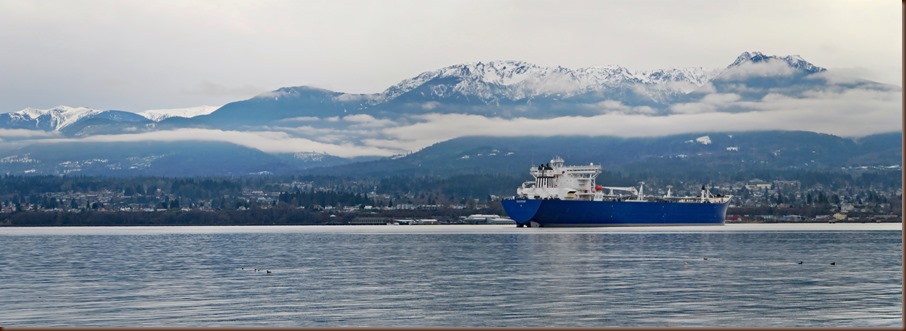
A tanker, Port Angeles, and the Olympic Mountains
Weather summary for January…
After easy weather in December, January was more normal with multiple strong storms. Each storm brought 40-50mph winds that rocked our trailer for hours at a time.
Average high temp: 44.6F Average low temp: 31.5F
Record high temp: 61F Record low temp: -3F
Average rain: 2.24 inches Average snow: 2.4 inches
Record rain: 4.87 inches Record snowfall: 17 inches
Observed high temperature: 62F
Observed low temperature: 30F
Measured rainfall: 1.96 inches
Measured snowfall: ZERO


Olympic Peninsula annual rainfall / Snowfall water equivalent on 31 Jan 2018. Olympic Mtns are at 131%
Adventures…
New Years…
Uncharacteristically for us, Arleen and I were out late on a New Year’s Eve. Deb and Tom invited us over to their home for dinner along with their friends Georgia and Rod.
The four of them also wanted help planning an RV trip to Colorado. That is right in my wheelhouse!
We enjoyed Tom’s prime rib, shared a bunch of stories, and played with the dogs. We were having such a wonderful time all six of were shocked when we looked at the clock & it was midnight…Happy New Year!


Deb and Georgia planning a big RV trip / Tom and his yummy prime rib
Hike in Olympic National Park…
The scenic Lake Crescent is in the northwest corner of Olympic National Park. Six years ago we rode our bikes on the Spruce Railroad Trail on the north side of the lake. Today, we returned to explore the south shore.
Lake Crescent formed due to a massive landslide over 7,000 years ago. Its beauty is highlighted with the scenic backdrop of Mount Storm King, Aurora Peak, and Sourdough Mountain.
Spilling down from Aurora Peak is Falls Creek and Marymere Falls. We parked at the Storm King Ranger Station, walked on the trail under Highway 101, and headed up the easy trail to the Falls.
The trail passes through areas of old growth. Old growth forest is something that has to be experienced in person to fully appreciate the huge old trees draped in moss. It’s humbling and inspiring to crane your neck straight up to follow the trunk and wonder what it’s like high up in the canopy and imagine what the tree has experienced during its hundreds of years of existence. A few old cedars took our breath away.
The pretty Marymere Falls plunges 90 feet. Winter is a good time to visit since the creek is swollen from nearly constant rains. There are two viewpoints but we preferred the lower overlook where the impact of the water’s power was more pronounced and we got a little wet from the fine spray.
On our way back we decided to detour up the Storm King Trail. We got an immediate aerobic workout as the trail climbed steeply on switchbacks. We were quickly out of the gorge and enjoyed spotty views of the lake through the trees.
Next, we took the Barnes Creek trail past Lake Crescent Lodge to the Moments in Time trail pausing along the way to appreciate the massive trees. Finally, we stopped at Barnes Point on Lake Crescent to admire the rocky beach and the clear water.


Hike route to Marymere Falls in Olympic National Park / We love walking these kinds of trails

Bridge across Barnes Creek


Marymere Falls, 90 feet high, is very pretty / Lake Crescent
Hike around Fort Flagler State Park…
A friend, Tracy, told us that Fort Flagler Historical State Park, on the northern tip of Marrowstone Island, was one of her favorite places to hike. We headed to the northeastern Olympic Peninsula and Fort Flagler the next day!
“Part of the Harbor Defense of Puget Sound, Fort Flagler, along with Fort Worden and Fort Casey, guarded the entrance to Puget Sound. These posts, established in the late 1890's, became the first line of a fortification system designed to prevent a hostile fleet from reaching the Bremerton Naval Yard and the cities of Seattle, Tacoma and Everett.
Construction began in 1897 and the fort closed in 1953. The property was purchased as a state park in 1955. Fort Flagler is named after Brigadier General Webster Flagler.”
The 784 acre park has 2 miles of beach trail and 4 miles of wooded trails. The park has 116 campsites and two group campsites. They have five historic vacation homes and a retreat center. The area has been very well maintained similar to Fort Worden but it is quieter at Flagler.
We parked near the Battery Wansboro and explored the old batteries and guns. We had great view of the North Cascade Mountain range to the east and 14,411foot tall Mount Rainier to the southeast.
From the battery it was a quick walk to the parade ground and the Park Office. The helpful lady there was able to give us a map and get us started down a wooded trail.
We followed the wooded trails northwest admiring a few old cedars in the dark woods. It looked like a prime area to hunt for mushrooms, but we only saw a few unedibles this late in the season.
We followed the bluff trail along the north edge pausing to check out searchlight areas and old batteries. We had a great view of Port Townsend and Fort Worden. It was nice just to sit and watch Navy vessels and ferries make their way through Puget Sound against the impressive backdrop of Mount Baker.
Finally, we made our way down off the bluff toward the picturesque Point Wilson Light. “It is one of the most important navigational aids in the state, overlooking the entrance to Admiralty Inlet, the waterway connecting the Strait of Juan de Fuca and Puget Sound.”
From there, it was a quick walk back to the truck to complete an interesting and scenic five mile hike. Thank you for the suggestion, Tracy!


Hike route around Fort Flagler / Map of Fort Flagler State Park
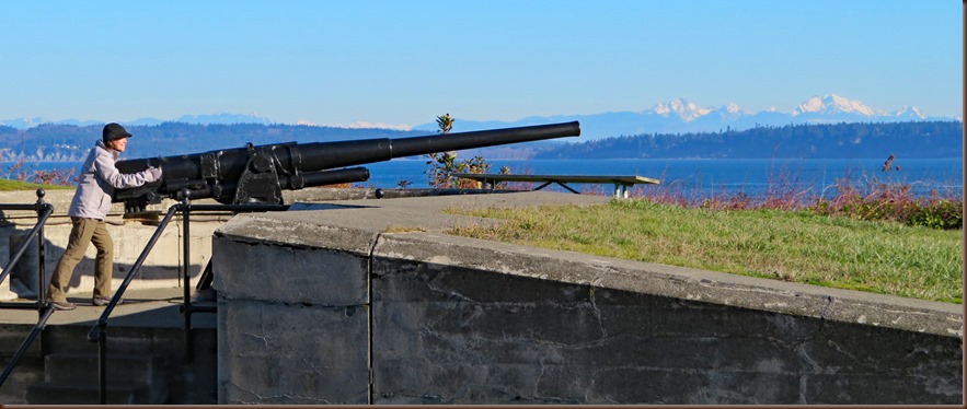
A big gun that protected vital shipping through Admiralty Inlet

One of the 10 batteries at Fort Flagler

Looking across Admiralty Inlet to Whidbey Island and impressive Mount Baker, 10,781 feet high
Adventure at Salt Creek Recreation Area…
Salt Creek Recreation Area is a 196-acre park Clallam County Park with a little bit of everything. For our first visit we walked around the entire area to get an idea of what it has to offer.
We parked at the Salt Creek Kiosk. From here the lower tide allowed us to walk along a part of the beach to where the creek flows into Crescent Bay. We got a great view of a moss draped island and the rocky Tongue Point.
Afterward, we followed the Beach to Bunker Trail to the remnants of Camp Hayden. Like other northwest locations, it was part of the World War II defensive system. They had good interpretive signs that helped us understand the area’s history, how the defenses were set up, and how the soldiers lived and worked.
We continued along the Bluff Trail to Tongue Point overlook. If the tide had been lower, we could have scrambled down and poked around in the tidal pools that are exposed during negative tides.
Next, we walked along the main park road and checked out the two campgrounds. The RV sites are nice long pull through sites, with a fantastic view of the Strait of Juan de Fuca. There are 92 campsites, 39 have water and electric. We walked by the basketball, volleyball, horseshoes, softball venues plus a big playground. In addition, visitors can go mountain biking or kayaking, scuba diving, or surfing. There is plenty for everyone to do here.
Finally, we hiked about a mile on a foot trail to “The Cove” overlook. The trail was a rolling wooded trail with occasional glimpses out to the strait. The Cove was a beautiful aqua color. There are a lot of wild Rhododendrons in amongst the red-bark Pacific Madrone trees. We could only imagine how pretty the forest would be in the spring with the white and pink blossoms against the turquoise water.
We’ll return to Salt Creek to explore the tide pools and hike up to Striped Peak.


Hike route around Salt Creek Recreation Area / Map of Salt Creek Recreation Area


A sea stack in Crescent Bay / Camp Hayden was built in 1941 to guard the Strait of Juan de Fuca


We appreciate trail work like this! / The Cove is very pretty

The rugged Washington coast and the Strait of Juan de Fuca
The Gray Wolf Loop hike…
When we leave John Wayne Resort and drive across Highway 101, we can drive up Palo Alto Road to a network of trails in the Olympic National Forest. We knew the road climbed and eventually tapered to narrow dirt, so we set off tentatively.
Palo Alto is all paved so that was a nice surprise. Then, we spotted a large herd of elk hanging out in hay fields. The day was starting off great!
After pleasant Palo Alto, we drove a few miles up a very narrow, twisting and dirt National Forest road. We found a nice parking area where the stock trail begins.
We hiked a perfect 3 mile loop from the stock trail to the Cutover Trail to the Lower Gray Wolf trail up to the actual parking lot and then walked the road back to the truck.
It was a lovely walk in the woods which is fine on a cloudy day. It was a typical northwest forest with some beautiful old growth Western Cedar and Douglas fir. At times we had glimpses of the namesake Gray Wolf River but the trail stayed high on a ridge. There were several creek crossings and we were thankful for the few bridges.
We would like to return to hike up to see the upper areas of the river that is supposed to be very pretty.
The are many other trails such as Tubal Cain Mine and Slab Camp Creek trails in the same area with nearly endless miles of trails as they connect into the National Park.
However, two weeks later a wind storm did significant damage to the area and several trees were down across the road. We’ll have to see how quickly the stretched Forest Service crews work to clear the mess.


Gray Wolf loop hike / The junction of the Cat Creek loop trail and Gray Wolf trail


It was a nice path through the forest / Clouds in the valley below us


A typical day on the Olympic Peninsula / A herd of elk were hanging out near Palo Alto Road
Long hike in Miller Peninsula State Park…
“In 2005, State Parks began a six-year project to establish one of Washington’s next destination state parks at Miller Peninsula, near Sequim.” The 2,800 acre park has a network of about 22 miles of trails and roads for hiking, mountain biking, and horse riding including a trail that goes down to the beach.
The park is only 8 miles from John Wayne Marina! We had to go check it out. Our goal was to make it to the beach.
We parked at the brand new east parking area that has plenty of space with a horse loading station and a comfort station.
We headed into the second growth forest on the easy Trailhead Loop which is wide and very smooth. We could have done that trail with a walker!
Then, we headed off onto the Diamond Point Trail. Now the trail was narrow and twisting with areas of rocks and roots. It cuts through a forest floor covered with lush salal and sword ferns. It is a perfect mountain bike single track!
At each intersection there is a kiosk and a posted trail map. At the “C” kiosk we headed north on the wide Fireweed Road.
Next, we took a right on the Beach Trail which dropped a couple hundred feet over a half mile to the our goal. The ravine took us through huge cedar stumps but also plenty of new cedars. We’re sure the loggers would drag the gargantuan trunks down the ravine to a barge which would boat them to the nearest mill.
The pretty beach consisted of small rounded colorful rocks and interesting sea debris. Each little wave moved the cobbles back and forth creating a soothing knocking sound. We had a great view of Protection Island National Wildlife Refuge. However, Mount Baker was obscured in clouds.
We quickly ate a snack and headed out. It was over 3 miles to get to the beach and we were taking a longer route back to turn it into an 8 mile track. We only had a few hours of daylight left.
We took an immediate right off Beach Trail and climbed the steep Bluff Trail. This path was fairly overgrown and the least maintained of the trails. It was a relief to pop out onto Fireweed which we double backed on to West Diamond Point Trail.
We had hiked down West Diamond Point a ways when we ran into trouble due to the recent heavy rains. Portions of the trail are level and have poor drainage. There was ankle deep water across the entire trail for a few hundred yards. There was no way to skirt it due to the impenetrable undergrowth and forest.
When we first run into such hazards, we cautiously tiptoe around the edges in order to keep water out of the boots. Then after water gets in and the socks and the feet are wet, we sigh and just plunge ahead. Not only does it save time, but we feel like kids as we splash along with few cares.
As we were wading through one of the deeper areas, a speck of orange plastic caught my eye submerged under a few inches of water. I instinctively knew it was the lost GPS from the notice at the trail head. I had taken a picture of it joking that we had a chance to find it.
I texted a picture to the owner and he eagerly responded. He is a Scout leader and was adding waypoints for his troop’s future adventure when he lost the GPS. The thankful Scout leader and his retriever were waiting for us at the trailhead.
In exchange, he shared good area trail information with us. He had offered us a coffee gift certificate but we said trail karma would find us.
As we loaded up in the truck, we noticed a state park citation tucked under our windshield wipers. We have the Discovery Pass for Washington State parks but didn’t write our license plate number on the pass. If we did not rectify by the end of the day, we would have to pay a stiff fine! And it was late!
As we drove by Sequim Bay State Park, we noticed some Rangers hanging outside by the garage. One was the ticket writer and he recognized our truck immediately. After introductions, he took our ticket and ripped it up. He offered some good hiking advice too. Trail karma at work!


7.5 mile hike route at Miller Peninsula State Park / Woods shrouded in fog


After 3.5 miles, we finally made it to the coast! / Interesting & colorful things that wash up on the beach


A salamander / We found his Garmin GPS!
Conquered Mount Walker…
The east coast of Olympic Peninsula along Hood Canal has quite a few trails up into the National Park and Forest. Mount Walker is one of the most easily accessed and popular.
On a mostly sunny morning in the middle of weeks of rain, we had to get out and climb for a view. The trail head for Mount Walker is right on Highway 101 so we would not have to tackle any water logged dirt roads.
Parking is very limited during the winter since the gate is closed. We were able to squeeze into a spot with five other cars that had arrived before us.
We hiked the two and a half mile trail up through a Douglas fir, Cedar and Western Hemlock forest. The Hemlock is easily recognized by the petite needles intertwined into a lace like pattern. There was a dense understory of small ferns, salal and bright scarlet leaves of Oregon grape.
The trail immediately pitched up for 2100 feet but on a pleasant, soft pine needle-carpeted trail. We love Mother Nature stair climbers like this! For the last few hundred feet the trail was lined with wet snow that had fallen the night before.
The view from the overlook was so worth the effort to get there. We got a good peak of the snow covered Olympic Mountains. It was too cloudy to see Baker or Rainier. So we’ll return on a good clear day.
We were both soaked from the misty forest and from our aerobic workout climbing Mount Walker. There was a stiff breeze and after just a few minutes of admiring the view, we started to feel chilled. We quickly snacked and headed down the road.
Our four miles route back down on road made for a perfect loop but also saved our knees a little bit. We kept a quick pace and slowly warmed up.
The top mile of the dirt road was covered with an inch of new snow. Interestingly, there was only one other set of footsteps which means most folks go up and down the steep trail. A rock slide towards the bottom covered the entire road with debris but it was easy to scramble over.
We look forward to a bright sunny day to return to Mount Walker!


Hike route up Mount Walker / About to start 2,000 feet of climbing in two miles


Snow near the top / Mount Constance, 7,743 feet high, is the third highest peak in the Olympic Mountains
Arleen’s adventure in Seattle…
Arleen: Deb invited me to go with her and Siesta to Seattle to visit the Chilhuly Garden and Glass.
It was a perfect training day for Guide Dog for the Blind puppy, Siesta because we used various types of transportation and moved through the city similar to the way her future partner might.
First, we drove to Bainbridge Island and took the ferry to Seattle. It was a perfect opportunity for Deb to take Siesta on some stair drills, up and down, and through the noisy car deck.
Then we were in Seattle! What a contrast! The traffic noise just assaults you as soon as you step off the ferry! Seattle is the largest city in the Pacific Northwest and the fastest growing major city in the United States.
The noise along the water front should be better by the end of the year when the Alaska Way Viaduct Replacement project, which began in 2011, is completed and will transfer the majority of the traffic to a two mile long tunnel under downtown Seattle.
We walked a few blocks east to catch the Metro Transit bus. Siesta did not seem phased by the noise and patiently waited at each corner for the crosswalk signs. On the bus, she laid happily at Deb’s feet. She certainly gets a lot smiles from people as she goes about her business.
Finally, we reached the Seattle Center area. “Originally built for the 1962 World's Fair, the 74-acre Seattle Center is an arts, educational, tourism and entertainment center in Seattle.”
Dale Chilhuly is a world renowned glass blower. “In 1971, Chihuly cofounded Pilchuck Glass School in Washington State. With this international glass center, Chihuly has led the avant-garde in the development of glass as a fine art.
His work is included in more than 200 museum collections worldwide. He has been the recipient of many awards, including twelve honorary doctorates and two fellowships from the National Endowment for the Arts. Chihuly Garden and Glass, a long-term exhibition, opened at Seattle Center in 2012.”
Deb, Siesta, and I first toured the inside exhibitions including the Seaforms and Chandeliers, a few of my favorites. The intense colors and the size of the sculptures was a surprise. Then we moved into the enormous atrium where a 100 foot long red, orange, yellow flower formation frames the Needle out the window.
Finally, we toured the garden, which has to be seen in its peak blooming time. It was a little early yet. “Anchored by four monumental sculptures, it is a rich backdrop for the art. Crimson camellias, scarlet daylilies, dogwoods, hardy fuchsias and handkerchief trees provide the setting for the Crystal and Icicle Towers and an installation of Reeds on Logs.”
We caught the bus back to the Seattle waterfront and had a delicious lunch at Kells Irish Restaurant. Again, Siesta settled down at Deb’s feet after a good drink of water and being admired by the owner and the waiter.
Next, we walked through Pike’s Place Market. There were so many sites, sounds and smells in there for a young dog to be distracted by. There were even a few other dogs. Deb quickly distracted Siesta with a well-timed kibble to keep her focused on her job.
On the ferry ride back, Deb and Siesta again climbed up and down several sets of steps to ingrain the process with her.
Siesta is off to formal training early in February. We wish her all the best in her important mission. But we look forward to meeting the next 8 weeks old Guide Dog for the Blind puppy Deb picks up that same day.

Heading to Seattle on the Bainbridge Ferry


Deb and Siesta on the ferry / Touring the Chihuly Garden and Glass exhibit in Seattle


The Space Needle reflected in a glass ball / Making more glass creations


Pike’s Place Market / The Seattle waterfront
A day with Bronte and Dora…
Tom and Deb are good responsible pet owners so when they planned an entire day in Seattle, they asked if we could look after the dogs and their cat, Emma, for the day. Plus, it would be good practice for when we house-sit and dog-sit for them in March.
We had a fun day hanging out with the wonder retrievers, Bronte and Dora. We took a few nice walks in the neighborhood.
I had a good time playing fetch with them. Dora normally shuffles around like an old dog. That changes when you throw a tennis ball. Dora can flat out RUN!
We really miss having a dog and look forward to when we settle down and have four-legged companions again.

We like hanging out with Bronte and Dora
Alpacas and Llamas…
Arleen and I have always been fascinated with alpacas. When we heard the Happy Valley Alpaca Ranch gives tours each Saturday, we made plans to visit.
The Alpaca farm is set in an idyllic location with soft green pastures back dropped by the impressive Olympic Mountains.
We popped in the store where they sell yarn, scarves, and other products woven from the alpaca fiber. “Alpaca fiber has a unique hollow insulating core which makes its fleece 6-7 times warmer than sheep's wool. Alpaca fiber has excellent qualities: thermal insulation, fiber strength, comfort, water resistant, wear resistance, and wrinkle resistance.”
Then we walked over to the alpaca pasture to admire the adorable and gentle animals.
We had a long conversation with Mike, the co-owner of the ranch. He was very good about answering our questions of the care for llamas and alpacas.
It would be good fun to attend Dyefeltorspin, their annual shearing and celebration of the fiber arts. But that happens in June, when we’ll be in Alaska.

Mike taught us a lot about alpacas and llamas
Next…
In April, we’ll hop on the ferry and head to Alaska for the summer!
Parting shots…


Just a few of the things we see during our walks near the campground: Whitefeather Way Road and Sequim Bay, a kingfisher looks for a meal, a great blue heron
(191,600)