


Three and a half weeks in Saint Regis, Montana…
Why we came…
Mostly because we couldn’t stay in Lolo so it gave us a chance to explore a remote area of Montana.
The campground…
The Nugget RV Park is a beautiful fifty acre facility back-dropped by the Bitterroot Mountains. It is conveniently located just off I-90 near the Saint Regis exit and 30 miles from the Montana/Idaho border.
Leslie and Mark, the owners, keep the park immaculately manicured. They and their numerous friendly camp hosts stay very busy with the high turnover due to the proximity to I-90. But this is not just a one night stopover spot.
There are 65 full hook sites with the largest being 30’ wide and 75’ long. We had a level site on the end of a row that was easy to pull into but it was tricky to get the truck situated next to one of the mature trees.
The trees also made satellite a challenge but we got dialed in for the first time in a month! It was nice to watch baseball again. We had a reliable 4 bar, LTE Verizon cell phone signal. Wi-fi was usually decent until the I-90 crowd bogged it down most evenings.
The park also offers cabins and tent sites. They keep the bathroom, private shower, and laundry room impeccably clean.
They have a small store, large heated swimming pool, 300-yard driving range, disc golf course, horseshoe pits, basketball court, kids play fort, a beach volleyball pit, badminton court, gem panning station, and a historic miner's camp. Plus, they have Mollie’s Dog Park which is about 6 acres. Finally, they have numerous trails in and around the park.
Highway noise was faint from our site but considerable from the sites at the front of the park. Train noise was inconsistent and occasionally made us stir in the middle of the night.
The 25,000 acre Sunrise wildfire was only 20 miles to our east. A few days we had easterly winds and the smoke was thick all day. Fortunately, for most of our stay, we had westerly winds. Under the inversion in the early morning hours, the smoke would back into our area and bring our visibility down to about a mile. We could smell and taste the smoke. Once the inversion broke around noon, it would clear out and we could see the pretty mountains again. Between three weeks of smoke in Lolo and another three weeks of smoke in Saint Regis, we had enough!
Trestle Creek Golf Course is right across the road. The Boyd Mountain Bike trail, a 5 mile downhill ride is just 3 miles west of Saint Regis. The Clark Fork and Saint Regis Rivers run through town and have good fishing.


We were comfortable at the Nugget RV Park / We had a bunch of smoky sunsets


Historic buildings in the campground
Nearby towns…
Saint Regis, elevation 2,635 feet and population 319, has a couple of gas stations, small grocery store, and a few restaurants. Also, there are two fly-fishing shops, a testament to the fact that you are near some great fishing.
“Nestled in the mountains of Western Montana and named for the nearby Saint Regis River is the community of Saint Regis. Once a booming mining and lumber town, today Saint Regis puts a heavy emphasis on tourism, serving as a shortcut of sorts to Flathead Lake and Glacier National Park. And if you're in town on Memorial Day, be sure to check out Montana's largest flea market.”
However, the main attraction is the Saint Regis Travel Center, which boasts its famous huckleberry shakes on road signs for miles in either direction. It was usually quite busy from lunch to dinner.
Superior, elevation 2,762 feet and population 812, is 14 miles to the southeast. It has a larger grocery store and a few gas stations. It also has a few restaurants. We highly recommend Durango’s. We ate there twice and thoroughly enjoyed their flavorful food. Superior also the has the largest medical facility in the sparsely populated region.
“An oasis off I-90, Superior offers travelers respite in this quaint community. For a taste of local flavor, spend the day floating or fishing the Clark Fork River as it flows through town. To experience the county's rich mining history, visit the Mineral County Museum. Superior also offers access to the road less traveled—the Saint Regis-Paradise National Forest Scenic Byway. The byway makes its way through the Lolo National Forest and past a variety of terrains, providing access to Flathead Lake and the National Bison Range.”
Missoula is 70 miles to the southeast and is the main supply and service center in the region.

Interstate 90 through Saint Regis MT
Adventures…
Fly-fishing the Saint Regis River…
The Saint Regis River parallels Interstate 90 roughly from Lookout Pass on the Montana/Idaho boarder east to the town of Saint Regis where it enters the mighty Clarks Fork. Though many people drive along the pretty river, very few stop to explore it. My research indicated that is has decent fishing in the lowest five or so miles and access is decent at nearly all highway exits.
I thoroughly fished a few sections of the Saint Regis River. Due to highway noise, it wasn’t peaceful. And though the fishing was slow, I still enjoyed it. The river is very pretty and has many runs and pools that look so promising. I only managed to catch a few good-sized whitefish. I’d rather catch the much prettier and harder fighting trout, but at least I didn’t get skunked! I imagine the fishing is better in spring and fall when trout move into the Saint Regis from the Clarks Fork.


There are some sweet fishing holes in the Saint Regis River / I only caught whitefish
Fly-fishing the Saint Joe River…
Idaho’s Saint Joe River has been featured in a few of my magazines and it’s been on my wish list. I was surprised and excited to see a winding mountain pass that connects the town of Saint Regis to that remote part of Idaho!
The Saint Joe River is loaded with cutthroat trout and has catch and release regulations. It’s remoteness ensures few fishermen and a pleasant wilderness experience…perfect!
The drive took me about 90 minutes. The Montana side is a maintained two-lane dirt road. Washboard was bad in places and logging trucks were speedy and often used more than their share of road. Right at the top of the pass as you enter Idaho, the road becomes smooth asphalt…it’s glorious.
Another 12 winding, but smooth miles from the pass, I finally saw the Saint Joe River. The medium sized stream looked beautiful. And there were signs to inform fishermen of the special regulations. I made a left turn on the narrow one lane road that parallels the upper Saint Joe River another 11 miles to the Spruce Tree Campground where the road ends. I stopped five miles up the road, grabbed my gear, and dropped down the river.
The fishing was fun! Beautifully colored cutthroat trout were in all the logical places. Most of them hammered my floating grasshopper fly, but a few hit a nymph dangled about 18 inches below. They averaged 10-14 inches and the biggest might have reached 16 inches. They were scrappy fighters and fun to catch.
I ended up fishing over a mile of river. The going was tough. I had to stay mostly in the water because the vegetation was so thick. The riverbed was full of slick rocks ranging from fist-sized to luggage-sized. I constantly fought to keep my balance and was worn out by the end of the day. Speaking of vegetation, I really enjoyed the ferns and big red cedars growing along the banks. The fishing was great. The setting was great! And my time on the Saint Joe River was great!


Hike and fish route along the St Joe River / Entering Idaho

The upper St Joe River

A slow deep run full of trout


A side creek entering the St Joe / Typical cutthroat trout / Ferns and cedars along the river

I caught trout on each side of the big boulder

These runs were fun to fish
Fly-fishing the Clark Fork…
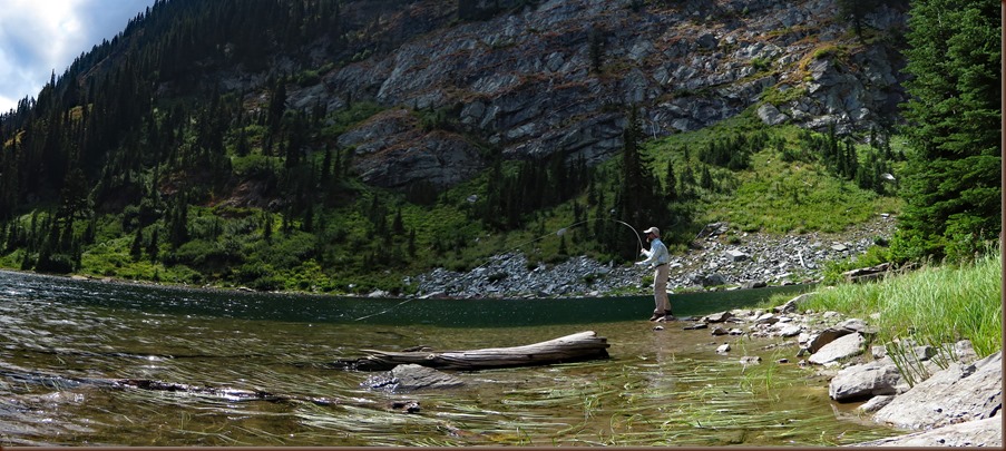
Interstate 90 parallels the Clark Fork from roughly Butte to Saint Regis. It’s big. In fact, it’s the largest river by volume in Montana. It’s also pretty. As you catch glimpses of it from the highway, “A River Runs Through It” crosses the mind. I don’t often fish large rivers, but the confluence of the Saint Regis River with the Clark Fork was too tempting. Besides, it was just a mile from our campground!
I fished the confluence a few different evenings. The weather was warm and the water temperature was pleasant so I waded wet. I really enjoyed stringing out long casts and waiting for a tug at the end of my line. A variety of fish swim in the Clarks Fork and some of the fish get big. My anticipation was high with each cast.
I felt the tug just four times. I caught three whitefish and one rainbow trout. I heard rumors of trout up to 29 inches long getting caught recently so I was a little disappointed, but at least I didn’t get skunked!

The confluence of the Saint Regis River and the mighty Clark Fork

Fly-fishing the Clark Fork during a beautiful Montana sunset
Adventure to Cliff Lake…
There are roughly 40 lakes tucked high in the Bitterroots in far western Montana. You can drive to a couple of them, hike to most of them, of some are nearly impossible to access. Some have fish and some don’t. Nearly all of them are pretty. I looked forward to exploring them!
My first Bitterroot high country lakes were Diamond and Cliff. I parked at Diamond Lake and headed up the fairly easy one and half mile trail to Cliff Lake.
Initially the air was fairly clear and I enjoyed good views of Diamond Lake. There were still quite a few flowers blooming, eatable thimble and huckleberries were were starting to fruit, and mountain views were pretty. It was very pleasant and I was enjoying the hike.
The second half of the trail pitched up and tucked under a lush forest. Sadly smoke from area fires was getting more noticeable.
I was glad to reach Cliff Lake. It was bigger than I expected and looked bottomless. As I headed to the south end of the pretty lake I spotted occasional ripples from small feeding fish. Now I knew that the lake had fish, could I catch them?
Numerous flowers were blooming in the marsh at the south end of the lake. Too bad Arleen wasn’t with me. She would have known them all!
I crossed the marsh and the banks dropped steeper to the water. I barely made it to my goal, a rock slide that butted up to vertical cliffs. It was one of the few places along the lake that I’d be able fly-fish and have a shot to hook a fish.
I continued to spot an occasional small feeding fish but none were within my range. I fished hard for about an hour to no avail. That’s alright. It was very pretty and the fish I could see were only 2 or 3 inches long.
The smoke was quite thick and a few people were getting rambunctious on the other side of the lake…It was time to go.


Hike route to Cliff Lake / A silly selfie


My start point: Diamond Lake / Looking down to Diamond Lake with smoke moving in

The lower part of the trail was very pleasant


There were lots of pretty flowers and berries

Cliff Lake


Scouting for trout at Cliff Lake / Saw a few small fish but didn’t get any bites
Adventure to Hub Lake…
Hub Lake was one of the longer and tougher routes I did.
There was just one other vehicle at the trailhead…cool! Less than a mile up the trail, a young couple and happy Brittany spaniel were heading down. They had spent the night and gave me a pretty good report.
Now I was completely alone and walking up a fairly steep trail through a thick forest. I occasionally sang to let big critters know that I was passing through.
I just caught glimpses of Hazel Lake through the trees. It definitely lived up to its name…it was very pretty, but it wasn’t my goal. I continued up the ever steepening trail towards Hub Lake.
Finally, about three and a half miles and 2,000 feet higher than my start, I was at Hub Lake. There was a sweet drop-off with plenty of casting room on the northwest side of the lake. As I worked my way over, I spotted a couple of small fish.
Little 4-7 inch long cutthroat trout consistently wacked my grasshopper fly for the next 90 minutes. I admired each one and thought about their harsh environment before releasing them back into the clear cold water. It was fun fishing!
The weather was perfect and there were just two other people at the pretty lake. Plus there was still plenty of time in the day so I screwed around a bit before heading back. I scrambled up some rocks and posed for silly pictures. Then I went a ways up the trail and did some more silly pictures…I was having fun!
I leapfrogged the other two hikers on the way down. I’d stop at a huckleberry patch and they’d pass me. Shortly after, they’d stop at a huckleberry and I’d pass them. We were well fueled for the trek back!


Hike route to Hub Lake / A beautiful waterfall along the trail


It’s huckleberry time! / Overlooking Hub Lake
Caught a bunch of small cutthroat trout…it was fun!
Adventure to Crystal Lake…
Crystal Lake is just six miles southwest of De Borgia MT, but it’s a narrow one-lane wide dirt road that is occasionally rough so the drive takes 20-30 minutes. The road dead ends at the trail head and I was glad to see no other vehicles. I was alone again!
I was expecting a rough and steep trail. It was steep but well maintained and nice to walk. My heart rate got up and I huffed and puffed and got a good workout.
There were even more berries. Thimble and huckleberries seemed to be peaking all along the trail. I plopped a few in my mouth each time I stopped. There were even raspberries popping in the rock falls near the lake.
My fishing spot was a rock fall on the south side of the lake. A brightly colored six inch long brook trout nailed my grasshopper on the first cast. I caught a bunch of 4-7 inchers over the next two hours. I fished from rocks a few feet above the water and loved watching them materialize from nowhere below my fly. Though the little guys were quick and aggressive, it seemed to happen in slow motion. I really enjoyed the action!
It was still early in the day and so I decided to tackle the ridge that I kept looking up at while I fished. I knew there was a trail most of the way, but I’d likely have to blaze my own route near the top.
Just a couple of hundred feet above the lake, I wandered through the largest huckleberry patch yet. I couldn’t resist stopping to eat a few mouthfuls and take a few pictures. It’s so cool to take advantage of nature’s bounty!
I popped up on the saddle between two small peaks and was disappointed to be in thick woods…there was no view! I headed towards a rock slide a couple of hundred feet higher that I knew would provide a good view.
It wasn’t steep but I wasn’t on a trail either so it was slow going. I hit the rock slide and carefully made my way out to the middle. Sure enough, the view was incredible! Crystal Lake shimmered nearly a thousand feet below and it was back-dropped by rugged woody peaks.
I ended up climbing over 2,000 feet in about two and a half miles. It was a tough but very rewarding day!


Hike route to Crystal Lake / The well maintained trail was often steep and went through lush forest

Crystal Lake. Note the raspberries on the left.

A nice mountain lake to fly-fish


Little brook trout loved my grasshopper fly / A handful of yummy huckleberries / Thimbleberries are good too

View from the ridge northwest of the lake
Square Lake attempt and Ward Peak conquer…
My goal was Square Lake. The hike starts on the ridge above the lake which is also the Montana/Idaho state line. I expected the hike to be steep, but was optimistic that I could make it if the descent was consistent.
It wasn’t. It stair-stepped down, each little drop steeper than the last. The footing was treacherous too. It varied from narrow foot holds to loose rocks to soggy marsh with mud and slick moss-covered rocks. I stopped to assess a 15 foot nearly vertical drop that would require use of all four of my limbs. A slip would have resulted in a fall much longer than 15 feet as the route was just a little less steep for a ways below. No thanks…too much risk! I had a little snack and scrambled back up. It was a good workout!
I got safely back to the car and checked out maps while I caught my breath. Ward Peak was nearby and a trail skirted around the southern side. Though my map didn’t show it, I was confident a side trail would lead to the top of the prominent peak.
So I hopped in the car anxious to conquer a 7’er! (A peak over 7,000 feet. This is a joke spoofing Colorado’s famous 14’ers.)
The narrow one lane dirt road got progressively worse as I drove west along the ridge line. I slowed to a crawl in a few places but never had to use 4WD. And thankfully I was all alone up there…there were no other vehicles.
I parked near a sign that said “Up Up Ridge Trail” and hit the trail. After the brutal Square Lake Trail, this path was glorious! It was well maintained, consistently pitched up, went through a plethora of yummy huckleberries, and had fantastic views. As expected, just over a half mile from my start, I spotted a side trail that climbed towards Ward Peak. It remained a very pleasant walk as it climbed to the west shoulder of the mountain.
I popped up on the ridge and had an even more incredible view. Now I straddled the Montana/Idaho state line and could see a long ways into both states.
The route got rockier but maintained a pleasant consistent pitch. I ascended the ridge for another half mile to finally reach the summit of Ward Peak, elevation 7,300 feet. I conquered a 7’er! I felt like a bird soaring high above the incredible terrain.
I snacked and took pictures but numerous bugs pestered me the whole time. There were four or five varieties of flying ants, a few beetles, flies, lots of ladybugs, and even some butterflies. Nothing bit me, but they continually landed on me and even got under my shirt. It was still awesome. I wasn’t going to let the bugs ruin my moment!


Hike route to Square Lake and Ward Peak / Square Lake is just a 1/2 mile with a 550 foot descent

Square Lake. I made it over half way down and turned back because the route was too steep.


Looking southeast across the Bitterroots from Up Up Ridge trail / Huckleberries everywhere…I ate a bunch!

Looking northeast into Montana from Ward Peak

Looking south into Idaho from Ward Peak
Getting Arleen out: 50,000 Silver $ and Camels Hump Lookout…
Two weeks after Arleen’s back surgery she was progressing very well and doing multiple mile long walks in the campground each day. I wanted to find something for her that would get her out, get her a view, and be a bit of a challenge.
Glancing over Google satellite, I noticed a fire lookout tower that would meet that criterion, but I wasn’t sure if we could get up there.
First, we drove to the Lincoln's World Famous 50,000 Silver $ Bar in Haugan MT. Our friend, Andy, wanted to know how many dollars were in the collection now. The silver dollar collection that was started in 1952 is now at 71,047 coins.
“Over $2500 are embedded in the bar top with the remainder graciously adorning the surrounding walls and ceiling. The total facility includes a restaurant, motel, free RV parking, gas station, convenience store, casinos, and Montana’s largest gift shop.”
Next we headed to the Camels Hump Lookout. The Old Mullan Road, also known as the Camels Hump Highway, was surprisingly paved. The 13 mile long road doesn’t really connect anything or go anywhere. It was likely part of the original two lane highway through the area.
Then we turned north on a narrow one-lane dirt road that snaked around for 7 miles and climbed 1,800 feet to a high saddle and a gate. The gate said “No motorized vehicles, but visitors are welcome”. We parked, walked around the gate, and enjoyed a leisurely mile long stroll up a gentle incline.
Arleen stayed on the road while I cut back into the woods on a hiking trail.
“The first lookout was a 20' pole tower with L-4 cab built in 1935. This was replaced by the present 41' treated timber tower with R-6 cab in 1960. It is staffed every summer.”
Don, the fire spotter, invited us up into Camels Hump lookout as soon as he saw us. He has manned the tower for 12 years. He works six, 10 hour long shifts every week and only leaves the tower once a week during his day off.
He takes two weather observations a day while he keeps a constant eye out for smoke. He has not spotted any fires this year. But we could clearly see the Sunrise Fire near Superior.
Don sees a bunch of critters, mostly deer, moose, elk, and an occasional bear. The tower has been struck by lightning many times!
He told us about two other nearby lookout towers available to rent in Lolo National forest: the Thompson Ridge and Up Up towers. They’re popular and need to be reserved about a year in advance.
Arleen was one day shy of her three week surgery mark. But she handled the walk and three flights of stairs, totaling of 350 feet of climbing, without an issue!


An interesting stop along I-90 in Haugan MT / This is just a portion of the 71,047 silver dollars.


Hike route to the Camels Hump Lookout / We’re going there!


The Camels Hump Lookout / Arleen on the tower with the Sunrise Fire in the background / Don has manned the tower every summer since 2005
The Great Eclipse…
Arleen clearly remembers a total eclipse in the late 70s. I vaguely remember it. Since we are science geeks, we were eager to see one together.
Arleen had read that during the eclipse, you could view a 360o sunset. We had to see that! Would 92% totality be enough? The show would be best from a high spot so we decided to head back to the Camels Hump lookout.
I picked up a piece of huckleberry pie for our new friend Don and Arleen packed us a picnic lunch. We headed out early to avoid the crowds.
We drove up the road and parked at the gate and we were mildly surprised that no one else was parked there. When we arrived at the tower, Don was working and had four friends visiting.
Before the eclipse began, I went in search of huckleberries. Even after it began, Arleen and I were busy filling our hands and mouths with the delicious berries.
We were not prepared with glasses or other devices to view the moon as it passed in front of the sun. Don’s friends had welder’s glass and let Arleen try them. We tried getting pictures with our phones and our two cameras. Arleen even tried using the welder’s glass in front of her camera lens.
We noted a significant drop in temperature. The birds stopped chirping. A cricket came out. There were still shadows but without crescent moon shapes etched in them. Most disappointingly, we did not see any alpenglow colors.
The lunar eclipse was a disappointment for us but the huckleberries were memorable. As we walked down the mountain road, we sang Toby Keith’s, “I'm gonna be your Huckleberry.”
While on the mountain, we were recording the Weather Channel’s coverage. When we got home we spent the afternoon watching the lunar eclipse from Oregon to Jackson Hole to Clemson to somewhere in the Atlantic. It was interesting to see different reactions from tears to cheering to Jim Cantore’s frustration over a cloud moving over the moon and sun during the crucial two minute eclipse.
We learned that 92% is not enough. You need 100% totality to experience the darkness and the 360o sunset. Maybe in 2024?

View southeast from the lookout tower. Are those the Rockies or the Smokies?!


Prior to the eclipse / During our eclipse peak of about 90%. It was slightly darker and noticeably cooler.


We picked and ate a bunch of yummy huckleberries during the eclipse
Arleen’s back recovery…
Arleen: The Nugget RV Park was a perfect place for us to stay and for me to recover from my back surgery. There are miles of trails that run through the woods around the park. I was able to go on shorter walks at first and then longer ones as I recovered.
I’d walk as many as six times a day. The first full week after surgery, I walked 24 miles (average of 7,000 steps a day). During the third week I walked 44 miles (average of 14,000 steps a day). During these strolls, I wondered if I were to trace all the possible varieties of trails and roads in the park, how many miles would I rack up?
So I set off to find out one morning. After I saw Shawn off to Crystal Lake, I donned my walking shoes, grabbed my walking stick, and hit the trail. I began with a basic route in mind: work the outer ring, and then move in and zigzag on trails off the outer ring.
I ambled around for exactly two hours and thirty minutes. I ended up hiking SIX miles and climbed over 400 feet on the rolling hills, my longest walk since early June!
The park has a tree face hunt game. I found four of the six hidden faces. After all my walking at the Nugget, two of the faces eluded me. My conclusion is that they must have fallen off of the trees.


Arleen’s SIX mile route around Nugget RV Park / She found 4 out of 6 of the tree faces
Where we got our mail…

The post office in Saint Regis, Montana
Next…
We were supposed to return to Lolo, but the campground was evacuated due to wildfire on 16 August. Now we are excited to spend three weeks in Columbia Falls MT to explore Glacier National Park! Then we stop at Joseph OR, Troy OR, and Carson WA as we work our way to the Oregon coast for fall.


Lolo Peak Fire on 2 Aug: 6,302 acres and 24 Aug: 34,184 acres. (Click the maps for a better view.)
Parting shots…


Stonefly nymph husks on the Saint Regis River / A grouse high in the Bitterroots


Dry dusty roads and smoke across the region / I warned them that rental car would get dirty!
(179,250)